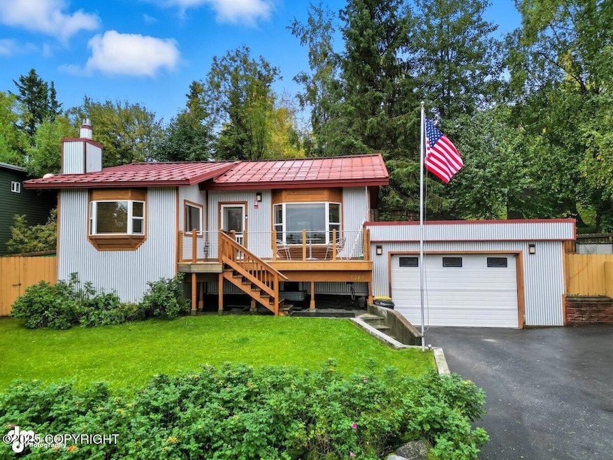
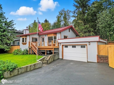
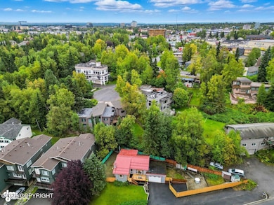
1945 Spenard Rd Anchorage, AK 99503
North Star NeighborhoodEstimated payment $2,857/month
Highlights
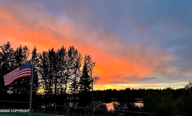
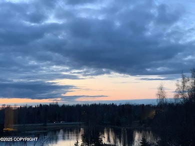
- Ocean View
- Spa
- Granite Flooring
- West High School Rated A
- Sauna
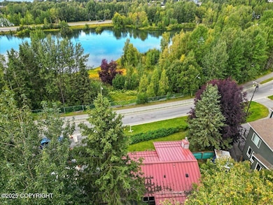
- 1-minute walk to Westchester Lagoon Nature Trail
About This Home
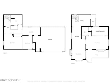
Custom 3BR/2BA home w/ million-dollar views of Westchester Lagoon! Enjoy sunsets & wildlife right from your living room. Kitchen features granite counters, SS appliances & tile flooring. Maple hardwood floors in the living room, dining & upstairs bedroom. Bathrooms finished in granite & tile, w/ jacuzzi & sauna. Daylight basement, gas fireplace, metal roof & siding.New heating system & on-demand water heater (2025). 2-car garage w/ 9' doors. RV parking, fenced yard, sheds. Across from park & trails! R2M zoning.
Home Details
Home Type
- Single Family
Est. Annual Taxes
- $2,896
Year Built
- Built in 1947
Lot Details
- 7,841 Sq Ft Lot
- Kennel
- Fenced
- Bluff on Lot
- Private Yard
- Property is zoned R2M, Multi Family Residential
Parking
- 2 Car Attached Garage
- Attached Carport
- Open Parking
Home Design
- Ranch Style House
- Metal Roof
- Metal Siding
Interior Spaces
- 1,723 Sq Ft Home
- Gas Fireplace
- Family Room
- Sauna
- Ocean Views
- Fire and Smoke Detector
- Washer and Dryer
- Basement
Kitchen
- Double Oven
- Gas Cooktop
- Microwave
- Dishwasher
- Granite Countertops
- Disposal
Flooring
- Wood
- Carpet
- Granite
- Marble
- Tile
Bedrooms and Bathrooms
- 3 Bedrooms
- 2 Full Bathrooms
- Soaking Tub
- Spa Bath
Outdoor Features
- Spa
- Deck
- Shed
Schools
- North Star Elementary School
- Romig Middle School
- West Anchorage High School
Utilities
- Baseboard Heating
Map
Home Values in the Area
Average Home Value in this Area
Tax History
| Year | Tax Paid | Tax Assessment Tax Assessment Total Assessment is a certain percentage of the fair market value that is determined by local assessors to be the total taxable value of land and additions on the property. | Land | Improvement |
|---|---|---|---|---|
| 2025 | $2,049 | $366,800 | $116,800 | $250,000 |
| 2024 | $2,049 | $351,900 | $116,800 | $235,100 |
| 2023 | $5,572 | $327,200 | $116,800 | $210,400 |
| 2022 | $1,800 | $306,900 | $116,700 | $190,200 |
| 2021 | $4,986 | $276,700 | $116,700 | $160,000 |
| 2020 | $4,158 | $294,900 | $116,700 | $178,200 |
| 2019 | $4,082 | $299,500 | $116,700 | $182,800 |
| 2018 | -- | $265,700 | $101,400 | $164,300 |
| 2017 | $3,862 | $266,600 | $88,700 | $177,900 |
| 2016 | -- | $271,600 | $83,500 | $188,100 |
| 2015 | $3,162 | $282,100 | $83,500 | $198,600 |
| 2014 | $3,162 | $258,000 | $83,500 | $174,500 |
Property History
| Date | Event | Price | List to Sale | Price per Sq Ft |
|---|---|---|---|---|
| 11/22/2025 11/22/25 | Price Changed | $498,700 | 0.0% | $289 / Sq Ft |
| 11/08/2025 11/08/25 | Price Changed | $498,800 | 0.0% | $289 / Sq Ft |
| 11/02/2025 11/02/25 | Price Changed | $498,900 | -2.1% | $290 / Sq Ft |
| 10/25/2025 10/25/25 | Price Changed | $509,700 | 0.0% | $296 / Sq Ft |
| 10/18/2025 10/18/25 | Price Changed | $509,800 | 0.0% | $296 / Sq Ft |
| 10/01/2025 10/01/25 | Price Changed | $509,900 | -1.8% | $296 / Sq Ft |
| 09/13/2025 09/13/25 | For Sale | $519,000 | -- | $301 / Sq Ft |
Purchase History
| Date | Type | Sale Price | Title Company |
|---|---|---|---|
| Warranty Deed | -- | None Listed On Document | |
| Quit Claim Deed | -- | -- | |
| Quit Claim Deed | -- | -- | |
| Interfamily Deed Transfer | -- | First American Title Co |
Mortgage History
| Date | Status | Loan Amount | Loan Type |
|---|---|---|---|
| Open | $257,398 | Seller Take Back | |
| Previous Owner | $25,000 | Purchase Money Mortgage | |
| Previous Owner | $25,000 | No Value Available |
Source: Alaska Multiple Listing Service
MLS Number: 25-11023
APN: 00115127000
Disclaimer: Certain information contained herein is derived from information provided by parties other than Homes.com. All information provided is deemed reliable, but is not guaranteed to be accurate and should be independently verified.
![]() The listing content relating to real estate for sale on this web site comes in part from the IDX Program of Alaska Multiple Listing Service, Inc. (AK MLS). Real estate listings held by brokerage firms other than Ten-X are marked with either the listing brokerage’s logo or the AK MLS logo and information about them includes the name of the listing brokerage. All information is deemed reliable but is not guaranteed and should be independently verified for accuracy. Copyright 2025 Alaska Multiple Listing Service, Inc. All rights reserved.
The listing content relating to real estate for sale on this web site comes in part from the IDX Program of Alaska Multiple Listing Service, Inc. (AK MLS). Real estate listings held by brokerage firms other than Ten-X are marked with either the listing brokerage’s logo or the AK MLS logo and information about them includes the name of the listing brokerage. All information is deemed reliable but is not guaranteed and should be independently verified for accuracy. Copyright 2025 Alaska Multiple Listing Service, Inc. All rights reserved.
- 2201 Romig Place Unit 105
- 1024 Potlatch Cir Unit 23
- 1113 W Fireweed Ln Unit 505
- 1113 W Fireweed Ln Unit 204
- 1327 W 25th Ave Unit 218
- 827 W 20th Ave
- 1435 W 25th Ave
- 1001 W Fireweed Ln
- 1501 P St
- 1471 W 26th Ave
- 1441 W 26th Ave Unit B3
- 1016 W 25th Ave
- 710 W 16th Ave
- 1607 W 14th Ave
- 2140 Dawson St
- 1575 F St
- 2607 Arctic Blvd
- 1908 Hillcrest Dr Unit 17
- 2400 Belmont Dr
- 1200 I St Unit 503
- 2201 Romig Place Unit 208
- 2201 Romig Place Unit 301
- 2201 Romig Place Unit 106
- 933 W 20th Ave Unit B
- 933 W 20th Ave Unit A
- 1303 W 23rd Ave
- 1435 W 25th Ave Unit 1
- 1400 W 25th Ave Unit 30
- 701 W 19th Ave
- 1460 W 26th Ave Unit 9
- 1046 W 26th Ave
- 1825 W 15th Ave Unit 1825
- 1854 Buccaneer Place Unit 2
- 1200 I St Unit 310
- 854 W 13th Ave Unit ID1284539P
- 2300 D St
- 808 W 29th Place Unit 7
- 843 W 11th Ave Unit 207
- 1752 W 11th Ave Unit B
- 1000 W 8th Ave
