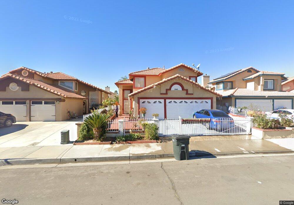
1946 Havasu St Perris, CA 92571
Central Perris NeighborhoodEstimated Value: $494,604 - $531,000
4
Beds
3
Baths
1,635
Sq Ft
$314/Sq Ft
Est. Value
About This Home
This home is located at 1946 Havasu St, Perris, CA 92571 and is currently estimated at $513,651, approximately $314 per square foot. 1946 Havasu St is a home located in Riverside County with nearby schools including Palms Elementary School, Pinacate Middle School, and Perris High School.
Ownership History
Date
Name
Owned For
Owner Type
Purchase Details
Closed on
Jun 20, 2016
Sold by
Naidu Satya and Naidu Santamma
Bought by
The Satya Naidu & Santamma Naidu Joint L
Current Estimated Value
Purchase Details
Closed on
Jan 2, 2004
Sold by
Naidu Satyanand
Bought by
Naidu Satyanand and Naidu Santamma
Purchase Details
Closed on
Sep 27, 1994
Sold by
Abueg Jose W and Abueg Maria L
Bought by
Naidu Satya N and Naidu Santamma
Home Financials for this Owner
Home Financials are based on the most recent Mortgage that was taken out on this home.
Original Mortgage
$89,750
Interest Rate
8.78%
Create a Home Valuation Report for This Property
The Home Valuation Report is an in-depth analysis detailing your home's value as well as a comparison with similar homes in the area
Home Values in the Area
Average Home Value in this Area
Purchase History
| Date | Buyer | Sale Price | Title Company |
|---|---|---|---|
| The Satya Naidu & Santamma Naidu Joint L | -- | None Available | |
| Naidu Satyanand | -- | Commerce Title Company | |
| Naidu Satya N | $94,500 | Orange Coast Title |
Source: Public Records
Mortgage History
| Date | Status | Borrower | Loan Amount |
|---|---|---|---|
| Closed | Naidu Satya N | $89,750 |
Source: Public Records
Tax History
| Year | Tax Paid | Tax Assessment Tax Assessment Total Assessment is a certain percentage of the fair market value that is determined by local assessors to be the total taxable value of land and additions on the property. | Land | Improvement |
|---|---|---|---|---|
| 2025 | $2,064 | $176,330 | $50,370 | $125,960 |
| 2023 | $2,064 | $169,485 | $48,415 | $121,070 |
| 2022 | $2,040 | $166,163 | $47,466 | $118,697 |
| 2021 | $2,002 | $162,906 | $46,536 | $116,370 |
| 2020 | $1,978 | $161,236 | $46,059 | $115,177 |
| 2019 | $1,934 | $158,075 | $45,156 | $112,919 |
| 2018 | $1,852 | $154,976 | $44,272 | $110,704 |
| 2017 | $2,146 | $151,938 | $43,404 | $108,534 |
| 2016 | $2,136 | $148,959 | $42,553 | $106,406 |
| 2015 | $2,120 | $146,723 | $41,915 | $104,808 |
| 2014 | $2,089 | $143,851 | $41,095 | $102,756 |
Source: Public Records
Map
Nearby Homes
- 507 Coudures Way
- 2248 Ridge Ct
- 544 Turquoise Dr
- 560 Coudures Way
- 1942 Sandcastle Dr
- 129 Olivetree Dr
- 1829 Springtree Dr
- 1900 Summertree Dr
- 1562 Remembrance Dr
- 2269 Firebrand Ave
- 21500 Orange Creek Rd
- 575 Prairie Way
- 1947 Neptune Dr
- 1509 Portrait St
- 1491 Portrait St
- 1486 Olivecrest Way
- 723 Anthirium Ave
- 166 Ambrosia Ct
- 1455 Remembrance Dr
- 705 Fuchsia Ln
- 1954 Havasu St
- 1938 Havasu St
- 1966 Havasu St
- 1943 Miramar St
- 1935 Miramar St
- 1951 Miramar St
- 1974 Havasu St
- 1923 Miramar St
- 1963 Miramar St
- 1945 Havasu St
- 1953 Havasu St
- 1937 Havasu St
- 1971 Miramar St
- 1965 Havasu St
- 1910 Havasu St
- 1925 Havasu St
- 1973 Havasu St
- 1979 Miramar St
- 1917 Havasu St
- 1907 Miramar St
Your Personal Tour Guide
Ask me questions while you tour the home.