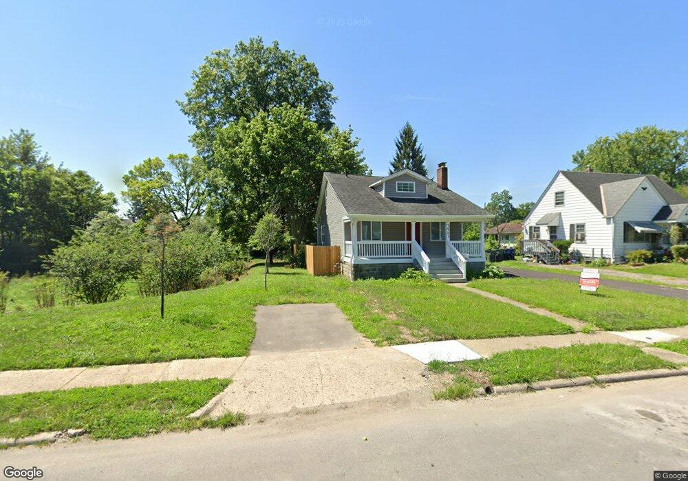
1947 Denune Ave Columbus, OH 43211
East Linden NeighborhoodEstimated Value: $191,966
3
Beds
2
Baths
1,807
Sq Ft
$106/Sq Ft
Est. Value
About This Home
This home is located at 1947 Denune Ave, Columbus, OH 43211 and is currently estimated at $191,966, approximately $106 per square foot. 1947 Denune Ave is a home located in Franklin County with nearby schools including Linden STEM Academy (K-6), Linden-Mckinley Stem School On Arcadia, and Focus Learning Academy of Central Columbus.
Ownership History
Date
Name
Owned For
Owner Type
Purchase Details
Closed on
Apr 24, 2020
Sold by
Central Ohio Community Improvement Corp
Bought by
City Of Columbus
Current Estimated Value
Purchase Details
Closed on
Jul 5, 2016
Sold by
Na Na
Bought by
Central Ohio Community Improvement Corpo
Purchase Details
Closed on
Apr 17, 2000
Sold by
Ragins Torris O
Bought by
Baker Kevin J
Home Financials for this Owner
Home Financials are based on the most recent Mortgage that was taken out on this home.
Original Mortgage
$51,894
Interest Rate
8.22%
Purchase Details
Closed on
Oct 13, 1992
Bought by
Ragins Torris O
Create a Home Valuation Report for This Property
The Home Valuation Report is an in-depth analysis detailing your home's value as well as a comparison with similar homes in the area
Home Values in the Area
Average Home Value in this Area
Purchase History
We collect this data history from publicly available records. To have your information removed, we recommend requesting removal directly through your county’s website.
| Date | Buyer | Sale Price | Title Company |
|---|---|---|---|
| City Of Columbus | -- | None Available | |
| Central Ohio Community Improvement Corpo | -- | None Available | |
| Baker Kevin J | $73,000 | -- | |
| Ragins Torris O | $31,000 | -- |
Source: Public Records
Mortgage History
We collect this data history from publicly available records. To have your information removed, we recommend requesting removal directly through your county’s website.
| Date | Status | Borrower | Loan Amount |
|---|---|---|---|
| Previous Owner | Baker Kevin J | $51,894 |
Source: Public Records
Tax History
| Year | Tax Paid | Tax Assessment Tax Assessment Total Assessment is a certain percentage of the fair market value that is determined by local assessors to be the total taxable value of land and additions on the property. | Land | Improvement |
|---|---|---|---|---|
| 2025 | -- | $11,480 | $11,480 | -- |
| 2024 | -- | $11,480 | $11,480 | -- |
| 2023 | $0 | $11,480 | $11,480 | $0 |
| 2022 | $0 | $2,630 | $2,630 | $0 |
| 2021 | $0 | $2,630 | $2,630 | $0 |
| 2020 | $0 | $5,260 | $2,630 | $2,630 |
| 2019 | $566 | $4,560 | $2,280 | $2,280 |
| 2018 | $566 | $4,560 | $2,280 | $2,280 |
| 2017 | $690 | $4,560 | $2,280 | $2,280 |
| 2016 | $41 | $7,350 | $2,800 | $4,550 |
| 2015 | $1,360 | $7,350 | $2,800 | $4,550 |
| 2014 | $456 | $7,350 | $2,800 | $4,550 |
| 2013 | -- | $8,645 | $3,290 | $5,355 |
Source: Public Records
Map
Nearby Homes
- 1967 Denune Ave
- 1913 Denune Ave
- 1951 Aberdeen Ave
- 1971 Aberdeen Ave
- 1326 Minnesota Ave
- 2508 Parkwood Ave
- 1814 Genessee Ave
- 2108 Paul Dr
- 2735 Berrell Ave
- 2451 Joyce Ave
- 2448 Parkwood Ave
- 1817 Milford Ave
- 1371 Aberdeen Ave
- 2823 Fern Ave
- 0 Aberdeen Ave Unit 226014407
- 0 Aberdeen Ave Unit 226002459
- 0 Aberdeen Ave Unit 226002457
- 0 Aberdeen Ave Unit 226002458
- 1938 Myrtle Ave
- 2586 Perdue Ave
- 1953 Denune Ave
- 1961 Denune Ave
- 1935 Denune Ave
- 1929 Denune Ave
- 1942 Aberdeen Ave
- 1973 Denune Ave
- 1973 E Denune
- 1930 Aberdeen Ave
- 1923 Denune Ave Unit 923
- 1952 Aberdeen Ave
- 1924 Aberdeen Ave
- 1960 Denune Ave
- 1938 Aberdeen Ave
- 1950 Denune Ave
- 1950 Denune Ave Unit A,B,C,D
- 1938 Denune Ave
- 1920 Aberdeen Ave
- 1944 Denune Ave
- 1964 Aberdeen Ave
- 1932 Denune Ave
Your Personal Tour Guide
Ask me questions while you tour the home.