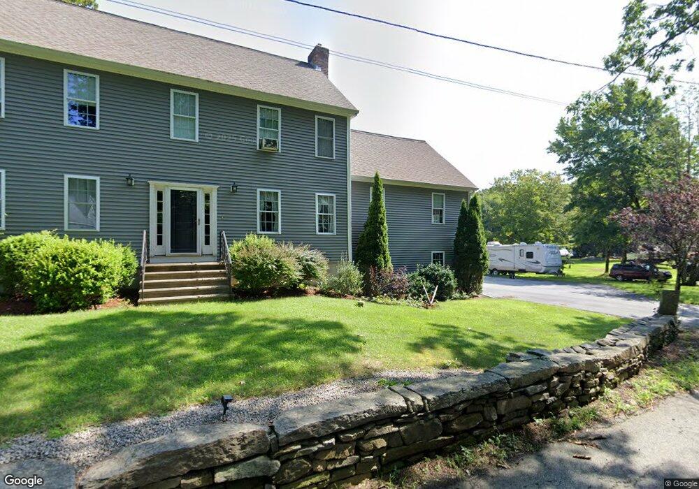
195 Hartness Rd Sutton, MA 01590
Estimated Value: $577,000 - $842,000
4
Beds
3
Baths
2,618
Sq Ft
$278/Sq Ft
Est. Value
About This Home
This home is located at 195 Hartness Rd, Sutton, MA 01590 and is currently estimated at $728,116, approximately $278 per square foot. 195 Hartness Rd is a home located in Worcester County with nearby schools including Sutton Elementary School, Sutton Middle School, and Sutton High School.
Ownership History
Date
Name
Owned For
Owner Type
Purchase Details
Closed on
Dec 17, 1997
Sold by
Coombs Ruth I
Bought by
Cardin Jeffrey J and Cardin Tracy A
Current Estimated Value
Create a Home Valuation Report for This Property
The Home Valuation Report is an in-depth analysis detailing your home's value as well as a comparison with similar homes in the area
Home Values in the Area
Average Home Value in this Area
Purchase History
| Date | Buyer | Sale Price | Title Company |
|---|---|---|---|
| Cardin Jeffrey J | $88,000 | -- |
Source: Public Records
Mortgage History
| Date | Status | Borrower | Loan Amount |
|---|---|---|---|
| Open | Cardin Jeffrey J | $200,000 | |
| Closed | Cardin Jeffrey J | $15,000 | |
| Closed | Cardin Jeffrey J | $165,000 |
Source: Public Records
Tax History
| Year | Tax Paid | Tax Assessment Tax Assessment Total Assessment is a certain percentage of the fair market value that is determined by local assessors to be the total taxable value of land and additions on the property. | Land | Improvement |
|---|---|---|---|---|
| 2025 | $8,333 | $693,300 | $179,100 | $514,200 |
| 2024 | $8,099 | $638,700 | $154,500 | $484,200 |
| 2023 | $7,691 | $555,300 | $135,400 | $419,900 |
| 2022 | $7,826 | $520,000 | $136,800 | $383,200 |
| 2021 | $7,826 | $489,100 | $136,800 | $352,300 |
| 2020 | $7,757 | $489,100 | $136,800 | $352,300 |
| 2019 | $7,533 | $456,000 | $136,800 | $319,200 |
| 2018 | $7,267 | $439,100 | $136,800 | $302,300 |
| 2017 | $6,559 | $397,500 | $120,100 | $277,400 |
| 2016 | $6,462 | $387,400 | $120,100 | $267,300 |
| 2015 | $6,237 | $373,900 | $120,100 | $253,800 |
| 2014 | $6,040 | $357,800 | $126,300 | $231,500 |
Source: Public Records
Map
Nearby Homes
- 191 Hartness Rd
- 7 Central Turnpike
- 79 Fisherville Terrace
- 53 Fisherville Terrace
- 55 Fisherville Terrace
- 44 Fisherville Terrace
- 5 Wildflower Dr
- 58 Fisherville Terrace
- 64 Fisherville Terrace
- 62 Fisherville Terrace
- 109 Main St
- 240 Roosevelt Dr
- 82 Central Turnpike
- 220 Alana Dr
- 86 Mikes Way Unit 86
- 51 Lincoln Rd
- 56 Luka Dr Unit 56
- 175 Armsby Rd
- 24 Mcquades Ln
- 20 Millers Way Unit C
- 66R Maple Ave
- 418 Pollard Rd
- 192 Hartness Rd
- 423 Pollard Rd
- 56 Maple Ave
- 188 Hartness Rd
- 58 Maple Ave
- 181 Hartness Rd
- 396 Pollard Rd
- 395 Pollard Rd
- 184 Hartness Rd
- 385 Pollard Rd
- 381 Pollard Rd
- 200 Hartness Rd
- 180 Hartness Rd
- 50 Aspen Ave
- 21 Hunters Ct Unit 21
- 382 Pollard Rd
- 19 Hunters Ct
- 46 Aspen Ave
Your Personal Tour Guide
Ask me questions while you tour the home.