Estimated Value: $81,000 - $171,000
--
Bed
2
Baths
1,268
Sq Ft
$102/Sq Ft
Est. Value
About This Home
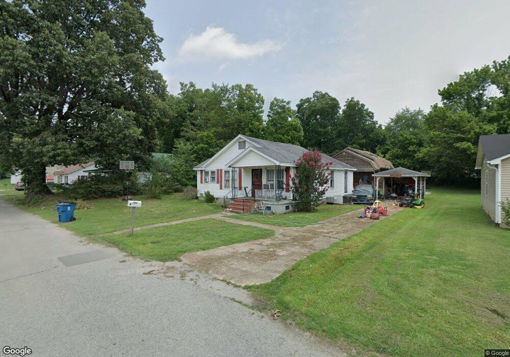
This home is located at 195 S Poplar St, Dyer, TN 38330 and is currently estimated at $129,414, approximately $102 per square foot. 195 S Poplar St is a home located in Gibson County with nearby schools including Dyer Elementary School and Gibson County High School.
Ownership History
Date
Name
Owned For
Owner Type
Purchase Details
Closed on
Jun 24, 2009
Sold by
Southstar I
Bought by
Evans Hessuca Heab
Current Estimated Value
Home Financials for this Owner
Home Financials are based on the most recent Mortgage that was taken out on this home.
Original Mortgage
$37,152
Interest Rate
4.88%
Purchase Details
Closed on
Sep 5, 2008
Sold by
Jones Keith
Bought by
Southstar I
Purchase Details
Closed on
Nov 23, 2005
Sold by
Barron Billy R
Bought by
Jones Keith
Home Financials for this Owner
Home Financials are based on the most recent Mortgage that was taken out on this home.
Original Mortgage
$66,600
Interest Rate
8.5%
Purchase Details
Closed on
May 4, 1988
Bought by
Stephenson Myrtle Ruth
Purchase Details
Closed on
Oct 16, 1951
Bought by
Stephenson Myrtle Ruth
Purchase Details
Closed on
Jan 3, 1900
Purchase Details
Closed on
Jan 2, 1900
Create a Home Valuation Report for This Property
The Home Valuation Report is an in-depth analysis detailing your home's value as well as a comparison with similar homes in the area
Home Values in the Area
Average Home Value in this Area
Purchase History
| Date | Buyer | Sale Price | Title Company |
|---|---|---|---|
| Evans Hessuca Heab | $33,500 | -- | |
| Southstar I | $45,000 | -- | |
| Jones Keith | $74,000 | -- | |
| Stephenson Myrtle Ruth | -- | -- | |
| Stephenson Myrtle Ruth | -- | -- | |
| -- | -- | -- | |
| -- | -- | -- |
Source: Public Records
Mortgage History
| Date | Status | Borrower | Loan Amount |
|---|---|---|---|
| Closed | Not Available | $37,152 | |
| Previous Owner | Not Available | $66,600 |
Source: Public Records
Tax History Compared to Growth
Tax History
| Year | Tax Paid | Tax Assessment Tax Assessment Total Assessment is a certain percentage of the fair market value that is determined by local assessors to be the total taxable value of land and additions on the property. | Land | Improvement |
|---|---|---|---|---|
| 2024 | $1,101 | $31,750 | $2,500 | $29,250 |
| 2023 | $582 | $18,725 | $1,150 | $17,575 |
| 2022 | $569 | $18,725 | $1,150 | $17,575 |
| 2021 | $569 | $18,725 | $1,150 | $17,575 |
| 2020 | $930 | $18,725 | $1,150 | $17,575 |
| 2019 | $930 | $18,725 | $1,150 | $17,575 |
| 2018 | $981 | $19,425 | $1,150 | $18,275 |
| 2017 | $942 | $19,425 | $1,150 | $18,275 |
| 2016 | $942 | $19,425 | $1,150 | $18,275 |
| 2015 | $858 | $19,425 | $1,150 | $18,275 |
| 2014 | $858 | $19,425 | $1,150 | $18,275 |
Source: Public Records
Map
Nearby Homes
- 299 E Walnut St
- 142 S Poplar St
- 217 Central St
- 354 E Maple St
- 139 Peach St
- 137 W South St
- 205 Division St
- 163 Monroe St
- 0 Royal St
- 246 Thomas St
- 208 & 210 Lee St
- 117 Washington St
- 548 E College St
- 288 W Broad St
- 153 New Hope St
- 173 Orr Rd
- 0 Reed Rd
- 148 Scattered Acres Loop
- 106 Scattered Acres Dr
- 23 Gravettes Crossing Rd W