Estimated Value: $553,000 - $639,000
5
Beds
3
Baths
2,576
Sq Ft
$231/Sq Ft
Est. Value
About This Home
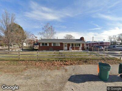
This home is located at 1950 N 600 W, Lehi, UT 84043 and is currently estimated at $595,637, approximately $231 per square foot. 1950 N 600 W is a home located in Utah County with nearby schools including Eaglecrest Elementary School, Lehi Junior High School, and Skyridge High School.
Ownership History
Date
Name
Owned For
Owner Type
Purchase Details
Closed on
May 27, 2020
Sold by
Smith Trev R and Smith Alison L
Bought by
Dorton Chris R and Dorton Lacey J
Current Estimated Value
Home Financials for this Owner
Home Financials are based on the most recent Mortgage that was taken out on this home.
Original Mortgage
$365,700
Outstanding Balance
$328,283
Interest Rate
3.3%
Mortgage Type
New Conventional
Estimated Equity
$267,354
Purchase Details
Closed on
Nov 9, 2012
Sold by
Smith Richard M
Bought by
Smith Trev R and Smith Alison L
Home Financials for this Owner
Home Financials are based on the most recent Mortgage that was taken out on this home.
Original Mortgage
$215,000
Interest Rate
3.35%
Mortgage Type
Purchase Money Mortgage
Purchase Details
Closed on
Nov 9, 2004
Sold by
Smith Richard M and Smith Julia H
Bought by
Smith Richard M and Smith Julia A
Create a Home Valuation Report for This Property
The Home Valuation Report is an in-depth analysis detailing your home's value as well as a comparison with similar homes in the area
Home Values in the Area
Average Home Value in this Area
Purchase History
| Date | Buyer | Sale Price | Title Company |
|---|---|---|---|
| Dorton Chris R | -- | First American Title Ns Co | |
| Smith Trev R | -- | Affiliated First Title Comp | |
| Smith Richard M | -- | -- |
Source: Public Records
Mortgage History
| Date | Status | Borrower | Loan Amount |
|---|---|---|---|
| Open | Dorton Chris R | $365,700 | |
| Previous Owner | Smith Trev R | $250,000 | |
| Previous Owner | Smith Trev R | $215,000 |
Source: Public Records
Tax History Compared to Growth
Tax History
| Year | Tax Paid | Tax Assessment Tax Assessment Total Assessment is a certain percentage of the fair market value that is determined by local assessors to be the total taxable value of land and additions on the property. | Land | Improvement |
|---|---|---|---|---|
| 2024 | $2,423 | $283,525 | $0 | $0 |
| 2023 | $2,230 | $283,305 | $0 | $0 |
| 2022 | $2,401 | $295,735 | $0 | $0 |
| 2021 | $2,146 | $399,600 | $127,200 | $272,400 |
| 2020 | $2,023 | $372,400 | $117,800 | $254,600 |
| 2019 | $1,773 | $339,200 | $117,800 | $221,400 |
| 2018 | $1,658 | $300,000 | $102,100 | $197,900 |
| 2017 | $1,509 | $145,090 | $0 | $0 |
| 2016 | $1,387 | $123,750 | $0 | $0 |
| 2015 | $1,327 | $112,420 | $0 | $0 |
| 2014 | $1,274 | $107,305 | $0 | $0 |
Source: Public Records
Map
Nearby Homes
- 1951 N Hollow Ct
- 454 W 1800 N
- 1817 W Bad Rock Cir Unit 100303
- 1693 W Westbury Unit D
- 1011 W Mountain Way Unit 316
- 1592 N 500 W
- 996 W Mountain Way Unit 329
- 2327 N 700 W
- 1708 N Trinnaman Ln
- 1014 W Mountain Way Unit 326
- 1549 N 300 W
- 441 W 2375 N
- 1910 N Center St
- 1235 W 1870 N
- 718 W 2530 N
- 567 W 2600 N
- 1331 N 900 W
- 627 W 1200 N Unit 1
- 689 W 1200 N
- 3730 W 1200 N Unit 132