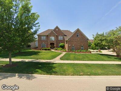
1951 Blossom Ln Aurora, IL 60503
Far Southeast NeighborhoodEstimated Value: $496,000 - $585,000
--
Bed
1
Bath
5,457
Sq Ft
$99/Sq Ft
Est. Value
About This Home
This home is located at 1951 Blossom Ln, Aurora, IL 60503 and is currently estimated at $538,674, approximately $98 per square foot. 1951 Blossom Ln is a home located in Will County with nearby schools including The Wheatlands Elementary School, Bednarcik Jr. High School, and Oswego East High School.
Ownership History
Date
Name
Owned For
Owner Type
Purchase Details
Closed on
Sep 30, 1998
Sold by
Overstreet Builders Inc
Bought by
Onyeabo Tony A and Onyeabo Felecia K
Current Estimated Value
Home Financials for this Owner
Home Financials are based on the most recent Mortgage that was taken out on this home.
Original Mortgage
$300,600
Interest Rate
6.97%
Create a Home Valuation Report for This Property
The Home Valuation Report is an in-depth analysis detailing your home's value as well as a comparison with similar homes in the area
Home Values in the Area
Average Home Value in this Area
Purchase History
| Date | Buyer | Sale Price | Title Company |
|---|---|---|---|
| Onyeabo Tony A | $334,500 | Collar Counties Title Plant |
Source: Public Records
Mortgage History
| Date | Status | Borrower | Loan Amount |
|---|---|---|---|
| Open | Onyeabo Tony A | $258,750 | |
| Closed | Onyeabo Tony A | $73,000 | |
| Closed | Onyeabo Tony A | $290,000 | |
| Closed | Onyeabo Tony A | $300,600 |
Source: Public Records
Tax History Compared to Growth
Tax History
| Year | Tax Paid | Tax Assessment Tax Assessment Total Assessment is a certain percentage of the fair market value that is determined by local assessors to be the total taxable value of land and additions on the property. | Land | Improvement |
|---|---|---|---|---|
| 2023 | $15,066 | $159,757 | $27,280 | $132,477 |
| 2022 | $13,863 | $145,306 | $25,805 | $119,501 |
| 2021 | $13,790 | $138,386 | $24,576 | $113,810 |
| 2020 | $13,206 | $136,194 | $24,187 | $112,007 |
| 2019 | $13,353 | $132,355 | $23,505 | $108,850 |
| 2018 | $13,304 | $127,598 | $22,988 | $104,610 |
| 2017 | $13,090 | $124,304 | $22,395 | $101,909 |
| 2016 | $13,128 | $121,628 | $21,913 | $99,715 |
| 2015 | $12,470 | $116,950 | $21,070 | $95,880 |
| 2014 | $12,470 | $103,220 | $21,070 | $82,150 |
| 2013 | $12,470 | $103,220 | $21,070 | $82,150 |
Source: Public Records
Map
Nearby Homes
- 2355 Avalon Ct
- 2410 Oakfield Ct
- 2270 Twilight Dr Unit 2270
- 2278 Twilight Dr
- 1932 Royal Ln
- 1874 Wisteria Dr Unit 333
- 2495 Hafenrichter Rd
- 2665 Tiffany St
- 3326 Fulshear Cir
- 3328 Fulshear Cir
- 3408 Fulshear Cir
- 2520 Dorothy Dr
- 2675 Dorothy Dr
- 1913 Misty Ridge Ln Unit 5
- 2525 Ridge Rd Unit 6
- 2136 Colonial St Unit 1
- 1917 Turtle Creek Ct
- 2397 Sunrise Cir Unit 35129
- 2197 Wilson Creek Cir Unit 3
- 2690 Moss Ln
- 1951 Blossom Ln
- 1963 Blossom Ln
- 2341 Mckenzie Ct
- 2375 Crabapple Ct
- 2368 Crabapple Ct
- 1975 Blossom Ln Unit 3A
- 2376 Crabapple Ct
- 2384 Crabapple Ct
- 1948 Blossom Ln Unit 3A
- 1960 Blossom Ln
- 2367 Crabapple Ct Unit 3A
- 2406 Geneva Ct Unit 3A
- 2360 Crabapple Ct
- 2374 Highwood Ct
- 2400 Mckenzie Ct
- 2382 Highwood Ct
- 2359 Crabapple Ct
- 2414 Geneva Ct
- 2415 Mckenzie Ct
- 2366 Highwood Ct