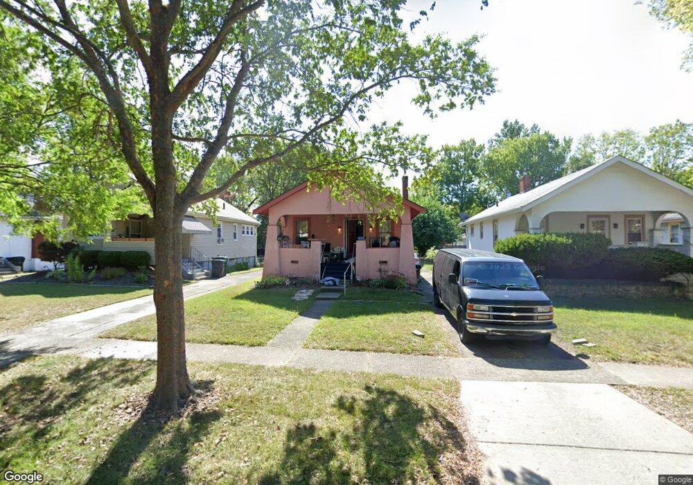
1951 Northcut Ave Cincinnati, OH 45237
Bond Hill NeighborhoodEstimated Value: $115,000 - $131,000
1
Bed
1
Bath
748
Sq Ft
$166/Sq Ft
Est. Value
About This Home
This home is located at 1951 Northcut Ave, Cincinnati, OH 45237 and is currently estimated at $123,999, approximately $165 per square foot. 1951 Northcut Ave is a home located in Hamilton County with nearby schools including Bond Hill Academy Elementary School, Shroder High School, and Clark Montessori High School.
Create a Home Valuation Report for This Property
The Home Valuation Report is an in-depth analysis detailing your home's value as well as a comparison with similar homes in the area
Home Values in the Area
Average Home Value in this Area
Tax History Compared to Growth
Tax History
| Year | Tax Paid | Tax Assessment Tax Assessment Total Assessment is a certain percentage of the fair market value that is determined by local assessors to be the total taxable value of land and additions on the property. | Land | Improvement |
|---|---|---|---|---|
| 2024 | $1,111 | $28,585 | $5,439 | $23,146 |
| 2023 | $1,188 | $28,585 | $5,439 | $23,146 |
| 2022 | $420 | $14,847 | $5,320 | $9,527 |
| 2021 | $388 | $14,847 | $5,320 | $9,527 |
| 2020 | $416 | $14,847 | $5,320 | $9,527 |
| 2019 | $378 | $13,878 | $4,974 | $8,904 |
| 2018 | $379 | $13,878 | $4,974 | $8,904 |
| 2017 | $352 | $13,878 | $4,974 | $8,904 |
| 2016 | $508 | $16,101 | $5,534 | $10,567 |
| 2015 | $466 | $16,101 | $5,534 | $10,567 |
| 2014 | $470 | $16,101 | $5,534 | $10,567 |
| 2013 | $608 | $18,088 | $6,216 | $11,872 |
Source: Public Records
Map
Nearby Homes
- 1943 Northcut Ave
- 1906 Andina Ave
- 5314 Section Ave
- 5334 Warren Ave
- 1946 Berkley Ave
- 5508 Warren Ave
- 1940 Dalewood Place
- 5601 Warren Ave
- 5328 Rolston Ave
- 5432 Rolston Ave
- 1843 Northcutt Ave
- 5343 Hunter Ave
- 1870 Dalewood Place
- 1855 Dalewood Place
- 5252 Warren Ave
- 5621 Rolston Ave
- 1917 Truitt Ave
- 1801 Northcut Ave
- 5258 Hunter Ave
- 1751 Andina Ave
- 1955 Northcut Ave
- 1947 Northcut Ave
- 1959 Northcut Ave
- 1959 Northcutt Ave
- 1963 Northcut Ave
- 1939 Northcut Ave
- 1950 Avonlea Ave
- 1946 Avonlea Ave
- 1954 Avonlea Ave
- 1933 Northcut Ave
- 1967 Northcut Ave
- 1942 Avonlea Ave
- 1958 Avonlea Ave
- 1946 Northcutt Ave
- 1938 Avonlea Ave
- 1962 Avonlea Ave
- 1931 Northcut Ave
- 1950 Northcut Ave
- 1971 Northcut Ave
- 1954 Northcut Ave