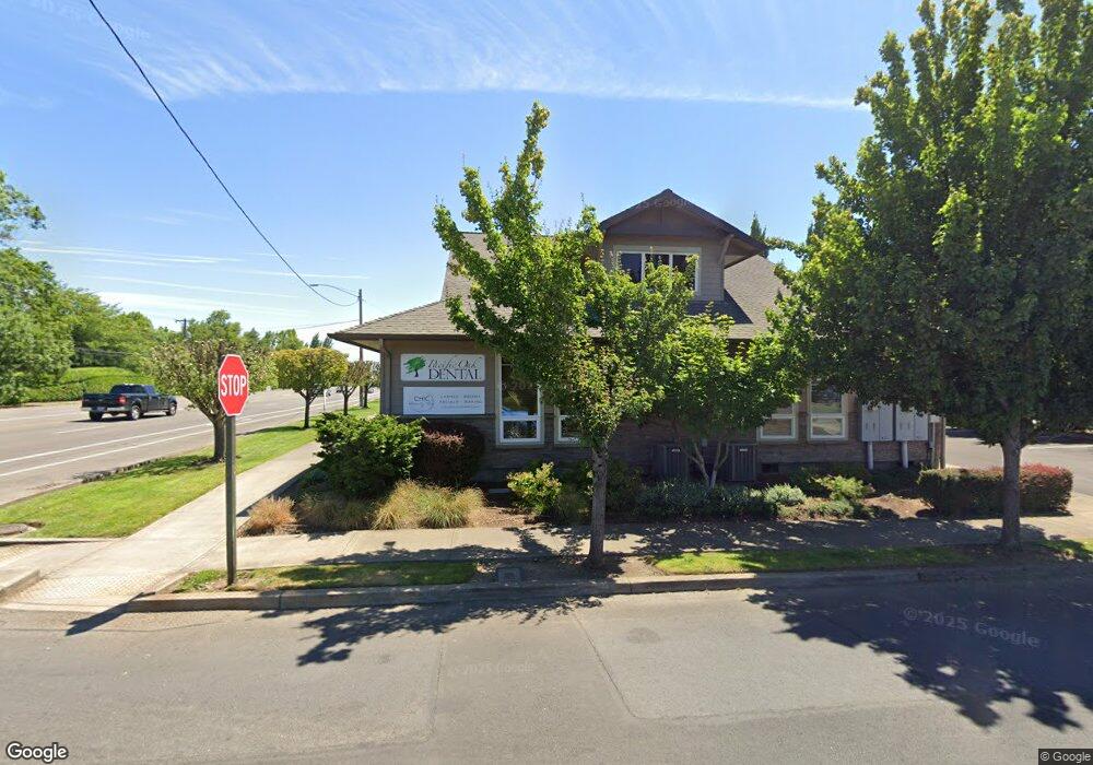
1951 Oak St Forest Grove, OR 97116
--
Bed
--
Bath
1,800
Sq Ft
0.3
Acres
About This Home
This home is located at 1951 Oak St, Forest Grove, OR 97116. 1951 Oak St is a home located in Washington County with nearby schools including Joseph Gale Elementary School, Neil Armstrong Middle School, and Tom McCall Upper Elementary School.
Ownership History
Date
Name
Owned For
Owner Type
Purchase Details
Closed on
May 1, 2015
Sold by
Jkt Properties Llc
Bought by
Pacoak Development Llc
Purchase Details
Closed on
Oct 13, 2010
Sold by
Karr James M
Bought by
Jkt Properties Llc
Home Financials for this Owner
Home Financials are based on the most recent Mortgage that was taken out on this home.
Original Mortgage
$330,000
Interest Rate
4.26%
Mortgage Type
Commercial
Purchase Details
Closed on
Feb 17, 1997
Sold by
Ditoma Thomas J and Ditoma Winifred M Karr
Bought by
Karr James M
Create a Home Valuation Report for This Property
The Home Valuation Report is an in-depth analysis detailing your home's value as well as a comparison with similar homes in the area
Home Values in the Area
Average Home Value in this Area
Purchase History
| Date | Buyer | Sale Price | Title Company |
|---|---|---|---|
| Pacoak Development Llc | -- | None Available | |
| The Murrey Group Inc | -- | None Available | |
| Lexi Investments Llc | -- | None Available | |
| Jkt Properties Llc | $160,000 | First Amer Title Ins Co Or | |
| Karr James M | $25,000 | Transnation Title Insurance |
Source: Public Records
Mortgage History
| Date | Status | Borrower | Loan Amount |
|---|---|---|---|
| Closed | Jkt Properties Llc | $330,000 |
Source: Public Records
Tax History Compared to Growth
Tax History
| Year | Tax Paid | Tax Assessment Tax Assessment Total Assessment is a certain percentage of the fair market value that is determined by local assessors to be the total taxable value of land and additions on the property. | Land | Improvement |
|---|---|---|---|---|
| 2026 | $9,145 | $513,530 | -- | -- |
| 2025 | $9,145 | $498,580 | -- | -- |
| 2024 | $8,822 | $484,060 | -- | -- |
| 2023 | $8,822 | $469,970 | $0 | $0 |
| 2022 | $7,714 | $469,970 | $0 | $0 |
| 2021 | $7,614 | $443,000 | $0 | $0 |
| 2020 | $7,573 | $430,100 | $0 | $0 |
| 2019 | $7,404 | $417,580 | $0 | $0 |
| 2018 | $7,177 | $405,420 | $0 | $0 |
| 2017 | $6,955 | $393,620 | $0 | $0 |
| 2016 | $6,759 | $382,160 | $0 | $0 |
| 2015 | $6,499 | $371,030 | $0 | $0 |
| 2014 | $6,166 | $343,420 | $0 | $0 |
Source: Public Records
Map
Nearby Homes
- 3404 19th Ave Unit 103
- 3404 19th Ave Unit 215
- 0 Kingwood St
- 2902 19th Ave
- 1835 Tamarack Ct
- 2366 Kingwood St
- 3831 Pacific Ave Unit D5
- 3831 Pacific Ave Unit D2
- 2828 22nd Ave Unit 3
- 2828 22nd Ave Unit 5
- 2824 19th Ave
- 3128 Brittany Dr
- 3213 Maple Place
- 2358 Kingwood St
- 2815 18th Ave
- 3839 Pacific Ave Unit 102
- 2369 NW Martin Rd
- 2303 NW Martin Rd
- 2341 NW Martin Rd
- 2820 23rd Place