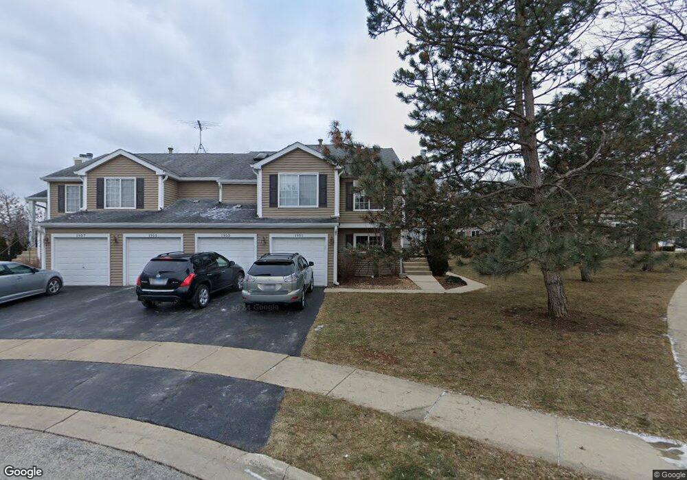
1951 Windsong Dr Unit 312E1 Schaumburg, IL 60194
West Schaumburg NeighborhoodEstimated Value: $248,253 - $271,000
2
Beds
--
Bath
1,200
Sq Ft
$220/Sq Ft
Est. Value
About This Home
This home is located at 1951 Windsong Dr Unit 312E1, Schaumburg, IL 60194 and is currently estimated at $263,563, approximately $219 per square foot. 1951 Windsong Dr Unit 312E1 is a home located in Cook County with nearby schools including Elizabeth Blackwell Elementary School, Dwight D Eisenhower Junior High School, and Hoffman Estates High School.
Ownership History
Date
Name
Owned For
Owner Type
Purchase Details
Closed on
Jul 11, 2024
Sold by
Ginter Gene M
Bought by
Gene M Ginter Living Trust and Ginter
Current Estimated Value
Purchase Details
Closed on
Nov 3, 2008
Sold by
Ginter Gene M
Bought by
Gene M Ginter Revocable Living Trust
Purchase Details
Closed on
May 23, 2005
Sold by
Chicago Title Land Trust Co
Bought by
Ginter Gene M
Home Financials for this Owner
Home Financials are based on the most recent Mortgage that was taken out on this home.
Original Mortgage
$85,000
Interest Rate
5.87%
Mortgage Type
Unknown
Purchase Details
Closed on
Jun 12, 1998
Sold by
Stoika Patricia
Bought by
The Chicago Trust Company and Trust #1105937
Create a Home Valuation Report for This Property
The Home Valuation Report is an in-depth analysis detailing your home's value as well as a comparison with similar homes in the area
Home Values in the Area
Average Home Value in this Area
Purchase History
| Date | Buyer | Sale Price | Title Company |
|---|---|---|---|
| Gene M Ginter Living Trust | -- | None Listed On Document | |
| Ginter Gene M | -- | None Listed On Document | |
| Gene M Ginter Revocable Living Trust | -- | None Available | |
| Ginter Gene M | $190,000 | Ticor | |
| The Chicago Trust Company | -- | Professional National Title | |
| Stoika Patricia | $110,000 | Professional National Title |
Source: Public Records
Mortgage History
| Date | Status | Borrower | Loan Amount |
|---|---|---|---|
| Previous Owner | Ginter Gene M | $85,000 | |
| Closed | Ginter Gene M | $95,500 |
Source: Public Records
Tax History Compared to Growth
Tax History
| Year | Tax Paid | Tax Assessment Tax Assessment Total Assessment is a certain percentage of the fair market value that is determined by local assessors to be the total taxable value of land and additions on the property. | Land | Improvement |
|---|---|---|---|---|
| 2024 | $3,519 | $18,569 | $3,038 | $15,531 |
| 2023 | $3,354 | $18,569 | $3,038 | $15,531 |
| 2022 | $3,354 | $18,569 | $3,038 | $15,531 |
| 2021 | $1,198 | $13,641 | $4,785 | $8,856 |
| 2020 | $1,098 | $13,641 | $4,785 | $8,856 |
| 2019 | $1,091 | $15,233 | $4,785 | $10,448 |
| 2018 | $1,225 | $12,587 | $2,962 | $9,625 |
| 2017 | $1,184 | $12,587 | $2,962 | $9,625 |
| 2016 | $1,759 | $12,587 | $2,962 | $9,625 |
| 2015 | $2,001 | $11,229 | $2,582 | $8,647 |
| 2014 | $1,937 | $11,229 | $2,582 | $8,647 |
| 2013 | $1,932 | $11,229 | $2,582 | $8,647 |
Source: Public Records
Map
Nearby Homes
- 1020 Denham Place Unit 1
- 1912 Finchley Ct Unit 3
- 808 Bishop Ct Unit 2
- 1103 Southbridge Ln
- 1121 Southbridge Ln
- 1375 Rebecca Dr Unit 318
- 2216 Andover Ct
- 1475 Rebecca Dr Unit 217
- 1698 Pebble Beach Dr
- 1672 Cornell Dr
- 1685 Cornell Dr
- 2312 Hyde Ct
- 2342 Hamilton Place
- 1901 Kingsley Dr
- 775 Harmon Blvd
- 2201 Brittany Ct Unit 20
- 1415 N Oakmont Rd
- 1763 Bristol Walk Unit 1763
- 604 N Brookdale Dr
- 1475 Crowfoot Cir S
- 1953 Windsong Dr Unit 2
- 1953 Windsong Dr Unit 314E1
- 1955 Windsong Dr Unit 313E1
- 1957 Windsong Dr Unit 311E1
- 1957 Windsong Dr Unit 31-1
- 1963 Windsong Dr Unit 324E1
- 1961 Windsong Dr Unit 322E1
- 1935 Windsong Dr Unit 303E1
- 1935 Windsong Dr Unit 1935
- 1935 Windsong Dr Unit 30-3
- 1937 Windsong Dr Unit 301E1
- 1937 Windsong Dr Unit 30-1
- 1965 Windsong Dr Unit 323E1
- 1931 Windsong Dr Unit 302E1
- 1933 Windsong Dr Unit 304E1
- 1933 Windsong Dr Unit 1933
- 1933 Windsong Dr Unit 30-4
- 1927 Windsong Dr Unit 291E1
- 1973 Windsong Dr Unit 334E1
- 1971 Windsong Dr Unit 332E1