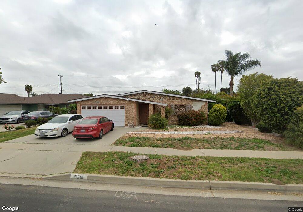
19518 Dunbrooke Ave Carson, CA 90746
Estimated Value: $793,987 - $913,000
4
Beds
2
Baths
1,586
Sq Ft
$530/Sq Ft
Est. Value
About This Home
This home is located at 19518 Dunbrooke Ave, Carson, CA 90746 and is currently estimated at $841,247, approximately $530 per square foot. 19518 Dunbrooke Ave is a home located in Los Angeles County with nearby schools including Leapwood Avenue Elementary School, Glenn Hammond Curtiss Middle School, and Rancho Dominguez Preparatory School.
Ownership History
Date
Name
Owned For
Owner Type
Purchase Details
Closed on
Nov 7, 2000
Sold by
James Cheryl M and Ward Cheryl James
Bought by
Smith Sundreya
Current Estimated Value
Home Financials for this Owner
Home Financials are based on the most recent Mortgage that was taken out on this home.
Original Mortgage
$218,250
Outstanding Balance
$79,158
Interest Rate
7.66%
Estimated Equity
$762,089
Purchase Details
Closed on
Aug 14, 1995
Sold by
White Elliott J
Bought by
James Cheryl Marie and White Cheryl Marie
Create a Home Valuation Report for This Property
The Home Valuation Report is an in-depth analysis detailing your home's value as well as a comparison with similar homes in the area
Home Values in the Area
Average Home Value in this Area
Purchase History
| Date | Buyer | Sale Price | Title Company |
|---|---|---|---|
| Smith Sundreya | $225,000 | South Coast Title | |
| James Cheryl Marie | $7,000 | -- |
Source: Public Records
Mortgage History
| Date | Status | Borrower | Loan Amount |
|---|---|---|---|
| Open | Smith Sundreya | $218,250 |
Source: Public Records
Tax History
| Year | Tax Paid | Tax Assessment Tax Assessment Total Assessment is a certain percentage of the fair market value that is determined by local assessors to be the total taxable value of land and additions on the property. | Land | Improvement |
|---|---|---|---|---|
| 2025 | $4,815 | $339,015 | $191,660 | $147,355 |
| 2024 | $4,815 | $332,368 | $187,902 | $144,466 |
| 2023 | $4,717 | $325,852 | $184,218 | $141,634 |
| 2022 | $4,488 | $319,463 | $180,606 | $138,857 |
| 2021 | $4,429 | $313,200 | $177,065 | $136,135 |
| 2019 | $4,264 | $303,913 | $171,814 | $132,099 |
| 2018 | $4,165 | $297,955 | $168,446 | $129,509 |
| 2016 | $3,984 | $286,387 | $161,906 | $124,481 |
| 2015 | $3,902 | $282,087 | $159,475 | $122,612 |
| 2014 | $3,893 | $276,563 | $156,352 | $120,211 |
Source: Public Records
Map
Nearby Homes
- 664 E Elsmere Dr
- 19327 Galway Ave
- 879 E Turmont St
- 19603 Enslow Dr
- 19202 Campaign Dr
- 19426 Belshaw Ave
- 956 E Gladwick St
- 19012 Tillman Ave
- 20203 Tillman Ave
- 17700 Avalon Blvd Unit 267
- 17700 Avalon Blvd Unit 387
- 17700 Avalon Blvd Unit 40
- 20600 Main St Unit 23
- 1351 E Bankers Dr
- 910 E Meadbrook St
- 19103 Hillford Ave
- 17701 S Avalon Blvd Unit 81
- 17701 Avalon Blvd
- 17701 Avalon Blvd Unit 291
- 17701 Avalon Blvd Unit 400
- 19512 Dunbrooke Ave
- 19524 Dunbrooke Ave
- 19515 Reinhart Ave
- 19521 Reinhart Ave
- 19504 Dunbrooke Ave
- 19530 Dunbrooke Ave
- 19509 Reinhart Ave
- 19527 Reinhart Ave
- 19521 Dunbrooke Ave
- 19515 Dunbrooke Ave
- 19527 Dunbrooke Ave
- 19509 Dunbrooke Ave
- 19424 Dunbrooke Ave
- 19503 Reinhart Ave
- 19533 Dunbrooke Ave
- 19503 Dunbrooke Ave
- 19418 Dunbrooke Ave
- 19421 Reinhart Ave
- 19518 Reinhart Ave
- 19602 Dunbrooke Ave
Your Personal Tour Guide
Ask me questions while you tour the home.