
1952 Combine Cir Apex, NC 27502
Friendship NeighborhoodEstimated payment $6,830/month
Highlights
- Recreation Room
- Radiant Floor
- Main Floor Primary Bedroom
- Scotts Ridge Elementary School Rated A
- Traditional Architecture
- Mud Room
About This Home
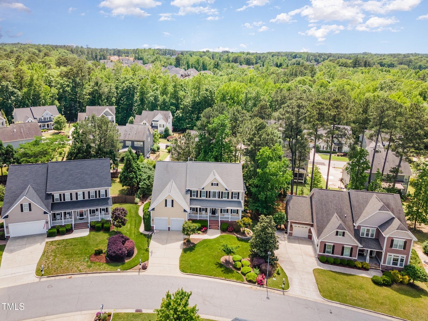
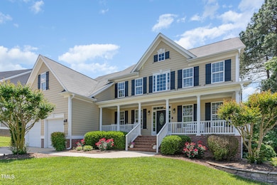
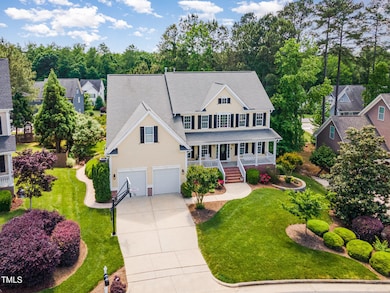
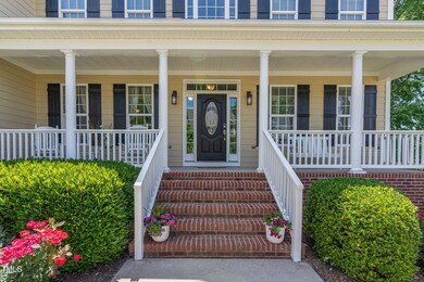
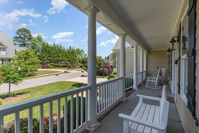
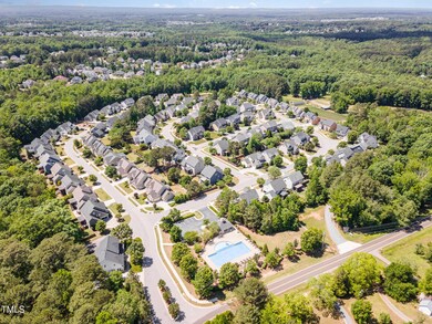
Apex Home with Expansive Walk-Out Basement, Huge Bonus Room & Private Outdoor Oasis Welcome to 1952 Combine Circle—a beautifully designed home in the sought-after Holland Farm community of Apex. With nearly 4,900 sq ft of finished living space and over 3,400 sq ft of unfinished flexibility, there's room to live, grow, work, and play with ease in one of the Triangle's most desirable locations. A striking floor-to-ceiling stone fireplace sets the tone in the living room, where gleaming hardwoods flow into bright, open spaces made for effortless connection. The gorgeous, functional kitchen features quartz counters, custom cabinetry, and premium appliances—perfectly positioned for everyday gathering and enjoyment. A spacious first-floor office provides privacy for remote work or study, while the sun-filled three-season room with EZ-Breeze windows and custom tile flooring invites morning coffee and relaxation. The main-floor owner's suite offers spa-quality comfort with heated floors, towel warmer, cultured marble counters, and refined tilework. Upstairs, a massive bonus room provides endless versatility—movie nights, crafting, gaming, or creative work—alongside three well-sized bedrooms designed for comfort and flexibility. On the lower level, the expansive full walk-out basement becomes entertainment central, complete with a three-TV media wall, surround sound, game areas, and multiple walk-in storage rooms. Beyond the finished zones lies 3,400+ sq ft of additional unfinished potential—loads of storage space plus ideal for future expansions such as a gym, workshop or guest suite. Step outside into a private backyard oasis designed for both excitement and tranquility. The stone patio with built-in grill, smoker, rotisserie, and firepit creates the perfect setting for celebrations, while the 325-gallon Hot Springs spa with motorized cover promises peaceful evenings beneath the stars. Professional landscaping, privacy, irrigation, and custom lighting ensure every moment outdoors is special. 1952 Combine Circle blends space, lifestyle, and premier Apex convenience—with proximity to top-rated schools, parks, shopping, and major employment centers—making every day feel effortlessly connected.
Home Details
Home Type
- Single Family
Est. Annual Taxes
- $8,401
Year Built
- Built in 2008
Lot Details
- 0.27 Acre Lot
- East Facing Home
HOA Fees
- $95 Monthly HOA Fees
Parking
- 2 Car Attached Garage
Home Design
- Traditional Architecture
- Brick Foundation
- Concrete Foundation
- Batts Insulation
- Shingle Roof
- Concrete Perimeter Foundation
- HardiePlank Type
Interior Spaces
- 2-Story Property
- Ceiling Fan
- Fireplace With Glass Doors
- Gas Log Fireplace
- Mud Room
- Living Room with Fireplace
- Breakfast Room
- Dining Room
- Home Office
- Recreation Room
- Bonus Room
- Laundry Room
Flooring
- Wood
- Carpet
- Radiant Floor
- Tile
Bedrooms and Bathrooms
- 4 Bedrooms
- Primary Bedroom on Main
- Primary bathroom on main floor
Partially Finished Basement
- Heated Basement
- Walk-Out Basement
- Exterior Basement Entry
- Block Basement Construction
- Stubbed For A Bathroom
- Basement Storage
Schools
- Scotts Ridge Elementary School
- Apex Middle School
- Apex Friendship High School
Utilities
- Zoned Heating and Cooling
- Heating System Uses Natural Gas
Community Details
- Association fees include ground maintenance
- Holland Farm Community Association, Phone Number (877) 672-2257
- Holland Farm Subdivision
Listing and Financial Details
- Home warranty included in the sale of the property
- Assessor Parcel Number 0721.04-93-6597.000
Map
Home Values in the Area
Average Home Value in this Area
Tax History
| Year | Tax Paid | Tax Assessment Tax Assessment Total Assessment is a certain percentage of the fair market value that is determined by local assessors to be the total taxable value of land and additions on the property. | Land | Improvement |
|---|---|---|---|---|
| 2025 | $8,593 | $981,921 | $170,000 | $811,921 |
| 2024 | $8,401 | $981,921 | $170,000 | $811,921 |
| 2023 | $6,358 | $577,759 | $105,000 | $472,759 |
| 2022 | $5,968 | $577,759 | $105,000 | $472,759 |
| 2021 | $5,740 | $577,759 | $105,000 | $472,759 |
| 2020 | $5,596 | $569,030 | $105,000 | $464,030 |
| 2019 | $5,988 | $525,532 | $105,000 | $420,532 |
| 2018 | $5,640 | $525,532 | $105,000 | $420,532 |
| 2017 | $5,249 | $525,532 | $105,000 | $420,532 |
| 2016 | $5,173 | $525,532 | $105,000 | $420,532 |
| 2015 | $5,434 | $538,968 | $78,000 | $460,968 |
| 2014 | $5,237 | $538,968 | $78,000 | $460,968 |
Property History
| Date | Event | Price | List to Sale | Price per Sq Ft |
|---|---|---|---|---|
| 10/15/2025 10/15/25 | Price Changed | $1,145,000 | -2.6% | $234 / Sq Ft |
| 09/18/2025 09/18/25 | Price Changed | $1,175,000 | -2.1% | $240 / Sq Ft |
| 08/28/2025 08/28/25 | Price Changed | $1,200,000 | -2.0% | $245 / Sq Ft |
| 07/24/2025 07/24/25 | For Sale | $1,225,000 | -- | $250 / Sq Ft |
Purchase History
| Date | Type | Sale Price | Title Company |
|---|---|---|---|
| Special Warranty Deed | $548,000 | None Available |
Mortgage History
| Date | Status | Loan Amount | Loan Type |
|---|---|---|---|
| Open | $520,300 | Purchase Money Mortgage |
Source: Doorify MLS
MLS Number: 10111558
APN: 0721.04-93-6597-000
Disclaimer: Certain information contained herein is derived from information provided by parties other than Homes.com. All information provided is deemed reliable, but is not guaranteed to be accurate and should be independently verified.
![]() Some IDX listings have been excluded from this IDX display. Brokers make an effort to deliver accurate information, but buyers should independently verify any information on which they will rely in a transaction. The listing broker shall not be responsible for any typographical errors, misinformation, or misprints, and they shall be held totally harmless from any damages arising from reliance upon this data. This data is provided exclusively for consumers’ personal, non-commercial use. Listings marked with an icon are provided courtesy of the Doorify MLS, Inc. of North Carolina, Internet Data Exchange Database. Closed (sold) listings may have been listed and/or sold by a real estate firm other than the firm(s) featured on this website. Closed data is not available until the sale of the property is recorded in the MLS. Home sale data is not an appraisal, CMA, competitive or comparative market analysis, or home valuation of any property. Copyright 2025 Doorify MLS, Inc. of North Carolina. All rights reserved.
Some IDX listings have been excluded from this IDX display. Brokers make an effort to deliver accurate information, but buyers should independently verify any information on which they will rely in a transaction. The listing broker shall not be responsible for any typographical errors, misinformation, or misprints, and they shall be held totally harmless from any damages arising from reliance upon this data. This data is provided exclusively for consumers’ personal, non-commercial use. Listings marked with an icon are provided courtesy of the Doorify MLS, Inc. of North Carolina, Internet Data Exchange Database. Closed (sold) listings may have been listed and/or sold by a real estate firm other than the firm(s) featured on this website. Closed data is not available until the sale of the property is recorded in the MLS. Home sale data is not an appraisal, CMA, competitive or comparative market analysis, or home valuation of any property. Copyright 2025 Doorify MLS, Inc. of North Carolina. All rights reserved.
- 2805 Evans Rd
- 1859 Versa Ct
- 7104 Camp Branch Ln
- 2098 Amalfi Place
- 1897 Lazio Ln
- 1126 Woodlands Creek Way
- 1124 Woodlands Creek Way
- 2048 Lazio Ln
- 1956 Lazio Ln
- 2170 Vittorio Ln
- 2908 Evans Rd
- 2145 Vecchio Ln
- 2428 Vetrina Way Unit 61
- 2429 Vetrina Way Unit 60
- 2437 Vetrina Way Unit 59
- Elizabeth Plan at Friendship Village
- Dillon Plan at Friendship Village
- Alexander Plan at Friendship Village
- Collins Plan at Friendship Village
- 2495 Vetrina Way Unit 49
- 2112 Jerimouth Dr
- 2023 Jerimouth Dr
- 2707 Abruzzo Dr
- 1802 Stroup St
- 7996 Humie Olive Rd
- 7994 Humie Olive Rd
- 2707 Masonboro Ferry Dr
- 2713 Masonboro Ferry Dr
- 2782 Masonboro Ferry Dr
- 404 Kinship Ln
- 2872 MacIntosh Woods Dr
- 417 Bergen Ave
- 2819 Macbeth Ln
- 1705 Barrett Run Trail
- 1036 Mica Lamp Ct
- 2819 Carbondale Ct
- 1811 Aspen River Ln
- 1765 Aspen River Ln
- 2914 Macbeth Ln
- 2221 Grants Pass Station
