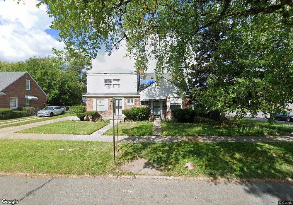
19545 Moross Rd Detroit, MI 48224
Moross-Morang NeighborhoodEstimated Value: $64,000 - $77,000
--
Bed
1
Bath
844
Sq Ft
$83/Sq Ft
Est. Value
About This Home
This home is located at 19545 Moross Rd, Detroit, MI 48224 and is currently estimated at $70,390, approximately $83 per square foot. 19545 Moross Rd is a home located in Wayne County with nearby schools including Carleton Elementary School, Edward 'Duke' Ellington Conservatory of Music and Art, and Charles L. Spain Elementary-Middle School.
Ownership History
Date
Name
Owned For
Owner Type
Purchase Details
Closed on
Jun 19, 2024
Sold by
All American Rental Llc
Bought by
Spratt Lori
Current Estimated Value
Purchase Details
Closed on
Jan 17, 2017
Sold by
Washington Claudette
Bought by
All American Rental Llc
Purchase Details
Closed on
Feb 18, 2014
Sold by
Fournier Florence
Bought by
Washington Claudette
Purchase Details
Closed on
Jan 23, 2014
Sold by
Grant Janis Marie
Bought by
Geletko Helen
Create a Home Valuation Report for This Property
The Home Valuation Report is an in-depth analysis detailing your home's value as well as a comparison with similar homes in the area
Home Values in the Area
Average Home Value in this Area
Purchase History
| Date | Buyer | Sale Price | Title Company |
|---|---|---|---|
| Spratt Lori | $5,000 | None Listed On Document | |
| All American Rental Llc | $8,000 | None Available | |
| Washington Claudette | $4,500 | Chirco Title Agency Inc | |
| Geletko Helen | -- | None Available |
Source: Public Records
Tax History Compared to Growth
Tax History
| Year | Tax Paid | Tax Assessment Tax Assessment Total Assessment is a certain percentage of the fair market value that is determined by local assessors to be the total taxable value of land and additions on the property. | Land | Improvement |
|---|---|---|---|---|
| 2025 | $853 | $24,600 | $0 | $0 |
| 2024 | $853 | $22,400 | $0 | $0 |
| 2023 | $1,073 | $17,400 | $0 | $0 |
| 2022 | $1,133 | $13,600 | $0 | $0 |
| 2021 | $1,107 | $12,600 | $0 | $0 |
| 2020 | $1,106 | $11,300 | $0 | $0 |
| 2019 | $992 | $8,600 | $0 | $0 |
| 2018 | $879 | $8,300 | $0 | $0 |
| 2017 | $146 | $7,700 | $0 | $0 |
| 2016 | $1,052 | $9,400 | $0 | $0 |
| 2015 | $940 | $9,400 | $0 | $0 |
| 2013 | $1,312 | $13,120 | $0 | $0 |
| 2010 | -- | $19,236 | $1,110 | $18,126 |
Source: Public Records
Map
Nearby Homes
- 19443 Mccormick St
- 19182 Beaconsfield St
- 19670 Mccormick St
- 19415 Moross Rd
- 19710 Moross Rd
- 11959 Roxbury St
- 11908 Roxbury St
- 19346 Moross Rd
- 19331 Mccormick St
- 19257 Beaconsfield St
- 12025 Lakepointe St
- 19701 Kingsville St
- 11764 Beaconsfield St
- 19725 Kingsville St
- 11640 Somerset Ave
- 19302 Moross Rd
- 19331 Kingsville St
- 11734 Beaconsfield St
- 11832 Roxbury St
- 11600 Somerset Ave
- 19537 Moross Rd
- 19529 Moross Rd
- 19521 Moross Rd
- 19601 Moross Rd
- 19515 Moross Rd
- 19452 Mccormick St
- 19505 Moross Rd
- 19623 Moross Rd
- 19130 Beaconsfield St
- 19444 Mccormick St
- 19434 Mccormick St
- 19501 Moross Rd
- 19625 Moross Rd
- 19153 Beaconsfield St
- 19637 Moross Rd
- 19426 Mccormick St
- 19455 Moross Rd
- 19152 Beaconsfield St
- 19542 Moross Rd
- 19538 Moross Rd