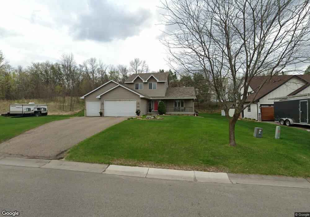
1955 Iris Dr Watertown, MN 55388
Estimated Value: $378,890 - $431,000
4
Beds
3
Baths
2,077
Sq Ft
$192/Sq Ft
Est. Value
About This Home
This home is located at 1955 Iris Dr, Watertown, MN 55388 and is currently estimated at $398,973, approximately $192 per square foot. 1955 Iris Dr is a home located in Carver County with nearby schools including Watertown-Mayer Elementary School, Watertown-Mayer Middle School, and Watertown Mayer High School.
Ownership History
Date
Name
Owned For
Owner Type
Purchase Details
Closed on
Feb 28, 2014
Sold by
State Of Minnesota
Bought by
Unglaub Michael R and Unglaub Jayne L
Current Estimated Value
Purchase Details
Closed on
Jun 30, 2005
Sold by
Drake Construction Inc
Bought by
Unglaub Michael R and Unglaub Jayne L
Home Financials for this Owner
Home Financials are based on the most recent Mortgage that was taken out on this home.
Original Mortgage
$208,632
Interest Rate
5.69%
Mortgage Type
New Conventional
Create a Home Valuation Report for This Property
The Home Valuation Report is an in-depth analysis detailing your home's value as well as a comparison with similar homes in the area
Home Values in the Area
Average Home Value in this Area
Purchase History
| Date | Buyer | Sale Price | Title Company |
|---|---|---|---|
| Unglaub Michael R | -- | None Available | |
| Unglaub Michael R | $260,791 | -- | |
| Drake Construction Inc | $56,900 | -- |
Source: Public Records
Mortgage History
| Date | Status | Borrower | Loan Amount |
|---|---|---|---|
| Previous Owner | Drake Construction Inc | $208,632 |
Source: Public Records
Tax History
| Year | Tax Paid | Tax Assessment Tax Assessment Total Assessment is a certain percentage of the fair market value that is determined by local assessors to be the total taxable value of land and additions on the property. | Land | Improvement |
|---|---|---|---|---|
| 2025 | $4,290 | $366,800 | $85,000 | $281,800 |
| 2024 | $4,236 | $353,600 | $85,000 | $268,600 |
| 2023 | $4,208 | $353,600 | $85,000 | $268,600 |
| 2022 | $3,956 | $357,400 | $79,900 | $277,500 |
| 2021 | $4,054 | $282,300 | $66,500 | $215,800 |
| 2020 | $4,088 | $282,300 | $66,500 | $215,800 |
| 2019 | $3,860 | $269,200 | $63,400 | $205,800 |
| 2018 | $3,550 | $269,200 | $63,400 | $205,800 |
| 2017 | $3,326 | $236,300 | $53,300 | $183,000 |
| 2016 | $2,994 | $182,700 | $0 | $0 |
| 2015 | $2,725 | $164,500 | $0 | $0 |
Source: Public Records
Map
Nearby Homes
- 209 Meadow Sweet Place
- 605 Sienna Dr
- 593 Sienna Dr
- 617 Sienna Dr
- 578 Sienna Dr
- 107 Shepherdia Ct
- 117 Wildflower Ct
- 932 Deerfield Rd
- 305 County Road 10 SE
- 865 Quail Ct
- 2325 Kristi Ln
- 832 Deerfield Rd
- XXX Newton Ave SE
- 545 Linden Ct
- 545 Linden Ln
- 570 Linden Ct
- 990 Bur Oak Ln
- 1316 Balsam Ln
- 1286 Balsam Ln
- 648 Hawthorne Ln
Your Personal Tour Guide
Ask me questions while you tour the home.