
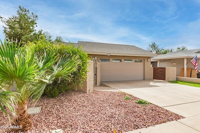
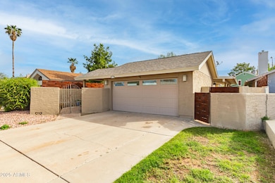
1955 N Illinois St Chandler, AZ 85225
North Chandler NeighborhoodEstimated payment $2,250/month
Highlights
- 0.11 Acre Lot
- Granite Countertops
- No HOA
- Andersen Elementary School Rated A-
- Private Yard
- Plantation Shutters
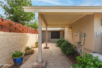
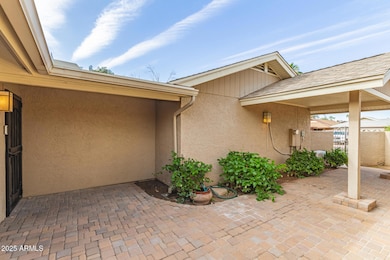
About This Home
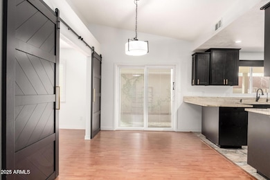
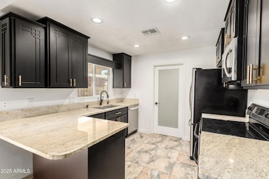
BRAND NEW: [HVAC-Dishwasher-Paint-Vanities-Fixtures!] Enjoy easy living in this updated 3-bedroom, 2-bath home! Featuring a 2-car garage and a private courtyard, this gem impresses with a freshly painted interior, rich wood-look flooring & plantation shutters. Living & dining room provides the perfect setting for relaxing or entertaining guests. Upscale kitchen displays plenty of cabinets adorned with crown moulding, recessed lighting, granite counters, stainless steel appliances, and a peninsula with a breakfast bar. Through double doors, you'll find the large primary bedroom offering direct outdoor access, a walk-in closet, and a private ensuite with a shower/tub combo. Spend relaxing afternoons under the covered patio. This turn-key value won't last. Hurry!
Listing Agent
Keller Williams Realty Phoenix License #SA648442000 Listed on: 10/16/2025

Home Details
Home Type
- Single Family
Est. Annual Taxes
- $1,094
Year Built
- Built in 1982
Lot Details
- 4,674 Sq Ft Lot
- Wrought Iron Fence
- Block Wall Fence
- Sprinklers on Timer
- Private Yard
- Grass Covered Lot
Parking
- 2 Car Garage
- Garage Door Opener
Home Design
- Wood Frame Construction
- Composition Roof
- Stucco
Interior Spaces
- 1,250 Sq Ft Home
- 1-Story Property
- Crown Molding
- Ceiling Fan
- Recessed Lighting
- Double Pane Windows
- Plantation Shutters
- Washer and Dryer Hookup
Kitchen
- Eat-In Kitchen
- Breakfast Bar
- Built-In Microwave
- Granite Countertops
Flooring
- Laminate
- Tile
Bedrooms and Bathrooms
- 3 Bedrooms
- Bathroom Updated in 2025
- Primary Bathroom is a Full Bathroom
- 2 Bathrooms
Schools
- John M Andersen Elementary School
- John M Andersen Jr High Middle School
- Chandler High School
Utilities
- Cooling System Updated in 2025
- Central Air
- High Speed Internet
- Cable TV Available
Additional Features
- No Interior Steps
- Patio
Community Details
- No Home Owners Association
- Association fees include no fees
- Knoell Cedar Ridge Lot 203 298 Tr A E Subdivision
Listing and Financial Details
- Tax Lot 280
- Assessor Parcel Number 302-41-083
Map
Home Values in the Area
Average Home Value in this Area
Tax History
| Year | Tax Paid | Tax Assessment Tax Assessment Total Assessment is a certain percentage of the fair market value that is determined by local assessors to be the total taxable value of land and additions on the property. | Land | Improvement |
|---|---|---|---|---|
| 2025 | $1,109 | $14,242 | -- | -- |
| 2024 | $1,072 | $13,564 | -- | -- |
| 2023 | $1,072 | $28,650 | $5,730 | $22,920 |
| 2022 | $1,034 | $20,880 | $4,170 | $16,710 |
| 2021 | $1,084 | $19,560 | $3,910 | $15,650 |
| 2020 | $1,079 | $18,200 | $3,640 | $14,560 |
| 2019 | $1,038 | $16,210 | $3,240 | $12,970 |
| 2018 | $1,005 | $13,950 | $2,790 | $11,160 |
| 2017 | $936 | $12,320 | $2,460 | $9,860 |
| 2016 | $902 | $10,780 | $2,150 | $8,630 |
| 2015 | $874 | $11,480 | $2,290 | $9,190 |
Property History
| Date | Event | Price | List to Sale | Price per Sq Ft |
|---|---|---|---|---|
| 11/03/2025 11/03/25 | Price Changed | $410,000 | -1.2% | $328 / Sq Ft |
| 10/16/2025 10/16/25 | For Sale | $415,000 | -- | $332 / Sq Ft |
Purchase History
| Date | Type | Sale Price | Title Company |
|---|---|---|---|
| Warranty Deed | -- | First Integrity Title | |
| Warranty Deed | -- | -- |
Mortgage History
| Date | Status | Loan Amount | Loan Type |
|---|---|---|---|
| Open | $290,250 | New Conventional |
Source: Arizona Regional Multiple Listing Service (ARMLS)
MLS Number: 6934771
APN: 302-41-083
Disclaimer: Certain information contained herein is derived from information provided by parties other than Homes.com. All information provided is deemed reliable, but is not guaranteed to be accurate and should be independently verified.
![]() All information should be verified by the recipient and none is guaranteed as accurate by ARMLS
All information should be verified by the recipient and none is guaranteed as accurate by ARMLS
Listing Information presented by local MLS brokerage: Ten-X, local REALTOR®- Arlene Richardson - (888)-952-6393
- 1970 N Hartford St Unit 84
- 1970 N Hartford St Unit 88
- 555 W Warner Rd Unit 127
- 555 W Warner Rd Unit 139
- 555 W Warner Rd Unit 156
- 1961 N Hartford St Unit 1055
- 1961 N Hartford St Unit 1178
- 1961 N Hartford St Unit 1092
- 2066 N Arbor Ln
- 2029 N Sunset Dr
- 1580 N Sunset Place
- 1419 N Vine St
- 1505 N Evergreen St Unit 17
- 1505 N Evergreen St Unit 42
- 728 W Calle Del Norte
- 525 W Sundance Way
- 2155 N Grace Blvd Unit 214
- 2155 N Grace Blvd Unit 202
- 2155 N Grace Blvd Unit 213
- 792 W El Monte Place Unit 8
- 1981 N Iowa St
- 1920 N Illinois St
- 1961 N Hartford St Unit 1161
- 1961 N Hartford St Unit 1186
- 568 W Caroline Ln
- 623 W Greentree Dr
- 1811 N Cheri Lynn Dr
- 2121 N Grace Blvd
- 2033 N Sunset Dr
- 2101 N Evergreen St
- 570 W Myrna Ln
- 1505 N Evergreen St Unit 17
- 2155 N Grace Blvd Unit 210
- 2155 N Grace Blvd Unit 127
- 730 W Kent Place
- 1420 N Evergreen St Unit 2
- 2400 N Arizona Ave
- 1351 N Pleasant Dr Unit 1101
- 807 W Palomino Dr
- 1184 N California St