
Seller's Agent in 2025
Jeana Hale-Dewitt
Badger Peabody & Smith Realty
(603) 520-1793
24 in this area
83 Total Sales
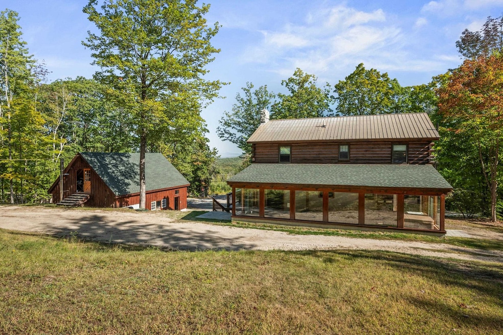
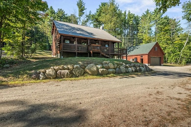
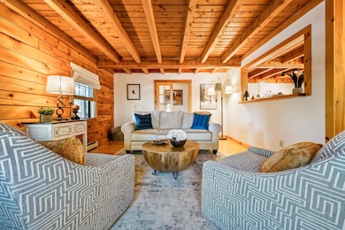

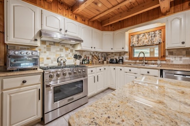
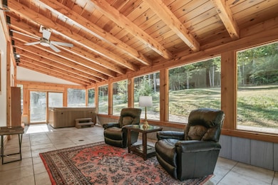

Welcome to this beautifully maintained log cabin in the quiet, rural setting of South Conway. Set on 1.66 sunny acres, this 3-bedroom, 2-bath home blends rustic charm with thoughtful updates for year-round comfort. The centerpiece is the updated kitchen with a large center island, abundant cabinet space, and stainless-steel appliances; perfect for entertaining or preparing family meals. From there, the home flows into a huge private sunroom with a hot tub, offering a relaxing retreat after a day on the trails or slopes. A first-floor bedroom and 3⁄4 bath with a custom tile shower provide easy main-level living. Upstairs, two oversized bedrooms with soaring cathedral ceilings share a full bath and feature generous closet space. Recent upgrades include a new roof to be installed and boiler in 2025. A full basement offers storage and utility space, while the attached one-car under garage adds convenience. For additional room, an oversized detached 2+ car garage with room above is ideal for vehicles, tools, or outdoor gear, or workshop. This property is the perfect year-round residence or ski-season getaway. Just minutes from Cranmore, Attitash, and King Pine ski areas, as well as hiking trails, rivers, and lakes, it’s an unbeatable location for four-season adventure. Enjoy the peaceful surroundings from the covered front porch or use the sunny lot for gardening and outdoor living. showings start 9/18/25 open house 9/20 10-1pm
Last Agent to Sell the Property
Badger Peabody & Smith Realty Brokerage Phone: 603-520-1793 License #054227 Listed on: 09/15/2025
| Date | Type | Sale Price | Title Company |
|---|---|---|---|
| Warranty Deed | $60,000 | -- | |
| Warranty Deed | $173,000 | -- | |
| Warranty Deed | $173,000 | -- | |
| Deed | $195,000 | -- | |
| Deed | $195,000 | -- |
| Date | Status | Loan Amount | Loan Type |
|---|---|---|---|
| Previous Owner | $165,000 | Purchase Money Mortgage | |
| Closed | $0 | No Value Available |
| Date | Event | Price | List to Sale | Price per Sq Ft |
|---|---|---|---|---|
| 11/07/2025 11/07/25 | Sold | $599,000 | 0.0% | $280 / Sq Ft |
| 09/15/2025 09/15/25 | For Sale | $599,000 | -- | $280 / Sq Ft |
| Year | Tax Paid | Tax Assessment Tax Assessment Total Assessment is a certain percentage of the fair market value that is determined by local assessors to be the total taxable value of land and additions on the property. | Land | Improvement |
|---|---|---|---|---|
| 2024 | $5,824 | $485,300 | $73,300 | $412,000 |
| 2023 | $5,333 | $494,300 | $73,300 | $421,000 |
| 2022 | $4,549 | $249,400 | $73,100 | $176,300 |
| 2021 | $4,031 | $246,700 | $73,100 | $173,600 |
| 2020 | $4,026 | $231,500 | $73,100 | $158,400 |
| 2019 | $4,010 | $231,500 | $73,100 | $158,400 |
| 2018 | $3,708 | $185,600 | $55,300 | $130,300 |
| 2017 | $3,445 | $172,400 | $55,300 | $117,100 |
| 2016 | $3,312 | $171,500 | $55,300 | $116,200 |
| 2015 | $3,222 | $168,800 | $55,300 | $113,500 |
| 2014 | $3,184 | $168,800 | $55,300 | $113,500 |
| 2013 | $3,070 | $171,900 | $55,300 | $116,600 |
Seller's Agent in 2025
Jeana Hale-Dewitt
Badger Peabody & Smith Realty
(603) 520-1793
24 in this area
83 Total Sales
Buyer's Agent in 2025
Melanie Norcross
Keller Williams Gateway Realty/Salem
(603) 560-3858
1 in this area
170 Total Sales
Source: PrimeMLS
MLS Number: 5061395
APN: CNWY-000284-000017-000002
Disclaimer: Certain information contained herein is derived from information provided by parties other than Homes.com. All information provided is deemed reliable, but is not guaranteed to be accurate and should be independently verified.
![]() Copyright 2026 PrimeMLS, Inc. All rights reserved. This information is deemed reliable, but not guaranteed. The data relating to real estate displayed on this display comes in part from the IDX Program of PrimeMLS. The information being provided is for consumers’ personal, non-commercial use and may not be used for any purpose other than to identify prospective properties consumers may be interested in purchasing.
Copyright 2026 PrimeMLS, Inc. All rights reserved. This information is deemed reliable, but not guaranteed. The data relating to real estate displayed on this display comes in part from the IDX Program of PrimeMLS. The information being provided is for consumers’ personal, non-commercial use and may not be used for any purpose other than to identify prospective properties consumers may be interested in purchasing.
Ask me questions while you tour the home.