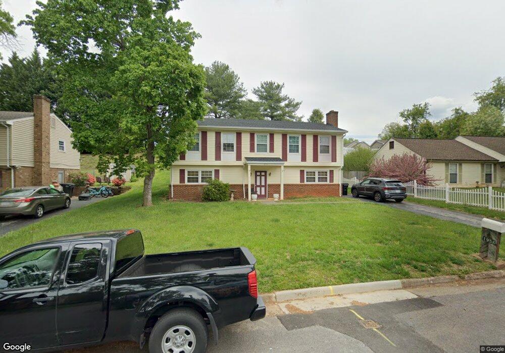
1956 Cambridge Dr Vinton, VA 24179
Estimated Value: $301,000 - $333,000
5
Beds
2
Baths
2,268
Sq Ft
$139/Sq Ft
Est. Value
About This Home
This home is located at 1956 Cambridge Dr, Vinton, VA 24179 and is currently estimated at $316,131, approximately $139 per square foot. 1956 Cambridge Dr is a home located in Roanoke County with nearby schools including W.E. Cundiff Elementary School, William Byrd Middle School, and William Byrd High School.
Ownership History
Date
Name
Owned For
Owner Type
Purchase Details
Closed on
Oct 21, 2009
Sold by
Anderson Jeffrey S and Anderson Debra M
Bought by
Criner Brian Keith and Criner Kristen Lee
Current Estimated Value
Home Financials for this Owner
Home Financials are based on the most recent Mortgage that was taken out on this home.
Original Mortgage
$163,959
Interest Rate
7.52%
Mortgage Type
FHA
Create a Home Valuation Report for This Property
The Home Valuation Report is an in-depth analysis detailing your home's value as well as a comparison with similar homes in the area
Home Values in the Area
Average Home Value in this Area
Purchase History
| Date | Buyer | Sale Price | Title Company |
|---|---|---|---|
| Criner Brian Keith | $167,000 | None Available |
Source: Public Records
Mortgage History
| Date | Status | Borrower | Loan Amount |
|---|---|---|---|
| Previous Owner | Criner Brian Keith | $163,959 |
Source: Public Records
Tax History Compared to Growth
Tax History
| Year | Tax Paid | Tax Assessment Tax Assessment Total Assessment is a certain percentage of the fair market value that is determined by local assessors to be the total taxable value of land and additions on the property. | Land | Improvement |
|---|---|---|---|---|
| 2025 | $2,507 | $243,400 | $50,000 | $193,400 |
| 2024 | $2,352 | $226,200 | $48,000 | $178,200 |
| 2023 | $2,147 | $202,500 | $44,000 | $158,500 |
| 2022 | $1,936 | $177,600 | $38,000 | $139,600 |
| 2021 | $1,775 | $162,800 | $33,000 | $129,800 |
| 2020 | $1,727 | $158,400 | $33,000 | $125,400 |
| 2019 | $1,611 | $147,800 | $30,000 | $117,800 |
| 2018 | $1,516 | $145,400 | $30,000 | $115,400 |
| 2017 | $1,516 | $139,100 | $30,000 | $109,100 |
| 2016 | $1,502 | $137,800 | $30,000 | $107,800 |
| 2015 | $1,504 | $138,000 | $30,000 | $108,000 |
| 2014 | $1,505 | $138,100 | $30,000 | $108,100 |
Source: Public Records
Map
Nearby Homes
- 0 Finney Dr
- 723 Finney Dr
- 1807 Parker Ln
- 2231 Hardy Rd
- 1918 Parker Ln
- 1802 Parker Ln
- 1819 Parker Ln
- 0 Halifax Cir
- 1819 Charlestown Square
- 1822 Charlestown Square
- 1818 Charlestown Square
- 617 Mcgeorge Dr
- 1902 Parker Ln
- 449 Missimer Ln
- 1914 Parker Ln
- 1893 Elizabeth Dr
- 1889 Elizabeth Dr
- 539 Missimer Ln
- 1038 Lauderdale Ave
- 226 Bush Dr
- 1948 Cambridge Dr
- 1962 Cambridge Dr
- 1881 Pembrook Dr
- 1940 Cambridge Dr
- 1873 Pembrook Dr
- 1945 Cambridge Dr
- 943 Pedigo Ln
- 1934 Cambridge Dr
- 1867 Pembrook Dr
- 1939 Cambridge Dr
- 1108 Pedigo Ln
- 1884 Pembrook Dr
- 1933 Cambridge Dr
- 1861 Pembrook Dr
- 1928 Cambridge Dr
- 1878 Pembrook Dr
- 1114 Pedigo Ln
- 1872 Pembrook Dr
- 935 Pedigo Ln
- 1927 Cambridge Dr