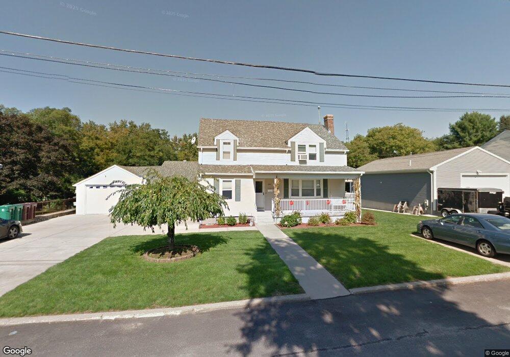
196 Cooper Ave Woonsocket, RI 02895
Bernon District NeighborhoodEstimated Value: $542,990 - $631,000
5
Beds
2
Baths
2,292
Sq Ft
$254/Sq Ft
Est. Value
About This Home
This home is located at 196 Cooper Ave, Woonsocket, RI 02895 and is currently estimated at $582,248, approximately $254 per square foot. 196 Cooper Ave is a home located in Providence County with nearby schools including Woonsocket High School, Founders Academy, and Beacon Charter School.
Ownership History
Date
Name
Owned For
Owner Type
Purchase Details
Closed on
Oct 20, 2009
Sold by
Losardo Dennis J and Losardo Patricia A
Bought by
Losardo Tr Dennis J and Losardo Patricia A
Current Estimated Value
Purchase Details
Closed on
Nov 28, 2000
Sold by
Campaniello Louise
Bought by
Losardo Patricia and Losardo Dennis
Purchase Details
Closed on
Jun 15, 1989
Sold by
Ouellette Richard E
Bought by
Losardo Denis J
Create a Home Valuation Report for This Property
The Home Valuation Report is an in-depth analysis detailing your home's value as well as a comparison with similar homes in the area
Home Values in the Area
Average Home Value in this Area
Purchase History
| Date | Buyer | Sale Price | Title Company |
|---|---|---|---|
| Losardo Tr Dennis J | -- | -- | |
| Losardo Tr Dennis J | -- | -- | |
| Losardo Patricia | $22,000 | -- | |
| Losardo Patricia | $22,000 | -- | |
| Losardo Denis J | $170,000 | -- |
Source: Public Records
Mortgage History
| Date | Status | Borrower | Loan Amount |
|---|---|---|---|
| Previous Owner | Losardo Denis J | $100,000 | |
| Previous Owner | Losardo Denis J | $101,000 |
Source: Public Records
Tax History
| Year | Tax Paid | Tax Assessment Tax Assessment Total Assessment is a certain percentage of the fair market value that is determined by local assessors to be the total taxable value of land and additions on the property. | Land | Improvement |
|---|---|---|---|---|
| 2025 | $6,188 | $551,000 | $109,200 | $441,800 |
| 2024 | $5,253 | $361,300 | $96,800 | $264,500 |
| 2023 | $5,051 | $361,300 | $96,800 | $264,500 |
| 2022 | $5,051 | $361,300 | $96,800 | $264,500 |
| 2021 | $4,612 | $194,200 | $60,700 | $133,500 |
| 2020 | $4,661 | $194,200 | $60,700 | $133,500 |
| 2018 | $4,676 | $194,200 | $60,700 | $133,500 |
| 2017 | $5,066 | $168,300 | $47,600 | $120,700 |
| 2016 | $5,359 | $168,300 | $47,600 | $120,700 |
| 2015 | $6,156 | $168,300 | $47,600 | $120,700 |
| 2014 | $5,629 | $172,100 | $52,400 | $119,700 |
Source: Public Records
Map
Nearby Homes
- 0 Irving Lot 206 Ave Unit 1397321
- 0 Irving Lot 192 Ave Unit 1383138
- 59 Cooper Ave
- 219 Crawford St
- 15 Knight St
- 190 Crawford St
- 59 Division St
- 0 Hillview St
- 122 Grand St
- 414 Rhode Island Ave
- 216 Bertenshaw Rd
- 526 Bernon St
- 1060 Park Ave
- 147 Warwick St
- 24 Paradis Ave
- 233 Grove St
- 74 Maple St
- 109 Hemond Ave
- 379 Front St
- 0 Caron Ave Unit 1379503
- 180 Cooper Ave
- 220 Cooper Ave
- 6 Bradley St
- 162 Cooper Ave
- 14 Bradley St
- 179 Cooper Ave
- 0 Irving Lot 206 Ave Unit 1383140
- 195 Jillson Ave
- 195 Jillson Ave Unit 187-195
- 195 Jillson Ave Unit B
- 195 Jillson Ave Unit 2
- 223 Cooper Ave
- 187 Jillson Ave
- 187 Jillson Ave Unit 187
- 187 Jillson Ave Unit A
- 26 Bradley St
- 159 Cooper Ave
- 157 Jillson Ave
- 157 Jillson Ave Unit B
- 199 Getchell Ave
Your Personal Tour Guide
Ask me questions while you tour the home.