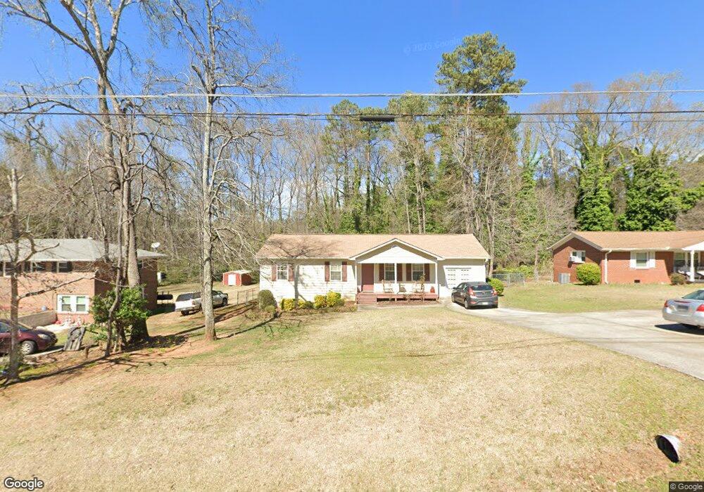
1960 Mcduffie Rd Austell, GA 30106
Estimated Value: $245,039 - $291,000
3
Beds
2
Baths
1,176
Sq Ft
$230/Sq Ft
Est. Value
About This Home
This home is located at 1960 Mcduffie Rd, Austell, GA 30106 and is currently estimated at $270,260, approximately $229 per square foot. 1960 Mcduffie Rd is a home located in Cobb County with nearby schools including Deerwood Elementary School, Clarkdale Elementary School, and Garrett Middle School.
Ownership History
Date
Name
Owned For
Owner Type
Purchase Details
Closed on
Nov 2, 2009
Sold by
Federal Natl Mtg Assn Fnma
Bought by
Reid Ronald E
Current Estimated Value
Home Financials for this Owner
Home Financials are based on the most recent Mortgage that was taken out on this home.
Original Mortgage
$67,041
Outstanding Balance
$43,418
Interest Rate
4.92%
Mortgage Type
VA
Estimated Equity
$226,842
Purchase Details
Closed on
Feb 4, 2009
Sold by
Countrywide Hm Loans Servicing
Bought by
Federal National Mortgage Association
Purchase Details
Closed on
Aug 15, 2003
Sold by
Morris Mitchell
Bought by
Atchinson Jonathan
Home Financials for this Owner
Home Financials are based on the most recent Mortgage that was taken out on this home.
Original Mortgage
$113,450
Interest Rate
6.32%
Mortgage Type
New Conventional
Create a Home Valuation Report for This Property
The Home Valuation Report is an in-depth analysis detailing your home's value as well as a comparison with similar homes in the area
Home Values in the Area
Average Home Value in this Area
Purchase History
| Date | Buyer | Sale Price | Title Company |
|---|---|---|---|
| Reid Ronald E | $64,900 | -- | |
| Federal National Mortgage Association | -- | -- | |
| Countrywide Hm Loans Servicing | $87,193 | -- | |
| Atchinson Jonathan | $117,000 | -- |
Source: Public Records
Mortgage History
| Date | Status | Borrower | Loan Amount |
|---|---|---|---|
| Open | Reid Ronald E | $67,041 | |
| Previous Owner | Atchinson Jonathan | $113,450 |
Source: Public Records
Tax History Compared to Growth
Tax History
| Year | Tax Paid | Tax Assessment Tax Assessment Total Assessment is a certain percentage of the fair market value that is determined by local assessors to be the total taxable value of land and additions on the property. | Land | Improvement |
|---|---|---|---|---|
| 2025 | $676 | $112,316 | $26,000 | $86,316 |
| 2024 | $678 | $112,316 | $26,000 | $86,316 |
| 2023 | $369 | $77,828 | $15,200 | $62,628 |
| 2022 | $575 | $77,828 | $15,200 | $62,628 |
| 2021 | $575 | $77,828 | $15,200 | $62,628 |
| 2020 | $494 | $50,720 | $14,000 | $36,720 |
| 2019 | $494 | $50,720 | $14,000 | $36,720 |
| 2018 | $466 | $48,060 | $14,000 | $34,060 |
| 2017 | $406 | $48,060 | $14,000 | $34,060 |
| 2016 | $407 | $48,060 | $14,000 | $34,060 |
| 2015 | $223 | $27,872 | $12,800 | $15,072 |
| 2014 | $228 | $27,872 | $0 | $0 |
Source: Public Records
Map
Nearby Homes
- 1968 Mcduffie Rd
- 1954 Mcduffie Rd
- 1976 Mcduffie Rd
- 1944 Mcduffie Rd
- 1981 Mcduffie Rd
- 1949 Mcduffie Rd
- 1992 Mcduffie Rd
- 1939 Mcduffie Rd
- 1914 Mcduffie Rd
- 2005 Mcduffie Rd
- 2016 Mcduffie Rd
- 1929 Mcduffie Rd
- 2015 Mcduffie Rd
- 1950 Drennon Ave
- 1948 Drennon Ave
- 1946 Drennon Ave
- 1946 Drennon Ave Unit 1946
- 1956 Drennon Ave
- 1956 Drennon Ave Unit 1956
- 1944 Drennon Ave