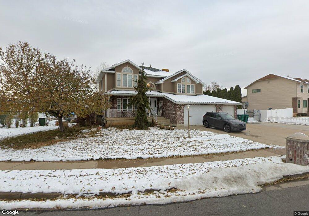
1961 N 2150 E Layton, UT 84040
Estimated Value: $746,000 - $933,000
4
Beds
3
Baths
2,624
Sq Ft
$304/Sq Ft
Est. Value
About This Home
This home is located at 1961 N 2150 E, Layton, UT 84040 and is currently estimated at $798,485, approximately $304 per square foot. 1961 N 2150 E is a home located in Davis County with nearby schools including Sarah Jane Adams Elementary School, North Layton Junior High School, and Northridge High School.
Ownership History
Date
Name
Owned For
Owner Type
Purchase Details
Closed on
Sep 24, 2025
Sold by
Boren Kim F and Boren Julie O
Bought by
Kim And Julie Boren Family Trust and Boren
Current Estimated Value
Purchase Details
Closed on
Jan 9, 2013
Sold by
Boren Kim F and Boren Julie O
Bought by
America First Federal Credit Union
Purchase Details
Closed on
Sep 26, 1995
Sold by
Boren Kim F and Boren Julie O
Bought by
Stauffer Kurt
Create a Home Valuation Report for This Property
The Home Valuation Report is an in-depth analysis detailing your home's value as well as a comparison with similar homes in the area
Home Values in the Area
Average Home Value in this Area
Purchase History
| Date | Buyer | Sale Price | Title Company |
|---|---|---|---|
| Kim And Julie Boren Family Trust | -- | None Listed On Document | |
| America First Federal Credit Union | $103,011 | First American Title | |
| Stauffer Kurt | -- | -- |
Source: Public Records
Tax History
| Year | Tax Paid | Tax Assessment Tax Assessment Total Assessment is a certain percentage of the fair market value that is determined by local assessors to be the total taxable value of land and additions on the property. | Land | Improvement |
|---|---|---|---|---|
| 2025 | $4,276 | $404,800 | $192,706 | $212,094 |
| 2024 | $3,976 | $382,250 | $200,862 | $181,388 |
| 2023 | $3,908 | $671,000 | $244,114 | $426,886 |
| 2022 | $4,041 | $379,500 | $133,190 | $246,310 |
| 2021 | $3,571 | $497,000 | $206,359 | $290,641 |
| 2020 | $3,257 | $433,000 | $182,399 | $250,601 |
| 2019 | $3,239 | $425,000 | $159,521 | $265,479 |
| 2018 | $2,998 | $394,000 | $136,935 | $257,065 |
| 2016 | $3,091 | $215,765 | $69,331 | $146,434 |
| 2015 | $3,076 | $205,865 | $69,331 | $136,534 |
| 2014 | $2,840 | $195,689 | $69,331 | $126,358 |
| 2013 | -- | $194,521 | $70,888 | $123,633 |
Source: Public Records
Map
Nearby Homes
- 1907 N Bridge Ct
- 2273 N 1975 E
- 2340 N 2050 E
- 2189 N 1950 E
- 2202 N 2300 E
- 1843 Hayes Dr
- 2391 Kays Creek Dr
- 2509 E 1900 N
- 2547 E 1900 N
- 1954 N 2600 E
- 1540 E Primrose Ln
- 1975 E 1425 N
- 2124 E Cherry Ln
- 2563 E 2250 N
- 3142 E Thorley Dr
- 3138 E Thorley Dr
- 2096 N 1450 E
- 2597 N 2300 E
- 1476 Kays Creek Dr
- 1465 E Sego Lily Ct
- 1997 N 2150 E
- 1941 N 2150 E
- 2110 E Antelope Dr
- 1952 N 2050 E
- 1960 N 2150 E
- 2076 E Antelope Dr
- 2076 E 2000 N
- 1938 N 2050 E
- 2115 E 1900 N
- 2162 E Antelope Dr
- 1960 N 2050 E
- 1935 N 2150 E
- 2357 E 1900 N
- 1922 N 2150 E
- 1920 N 2050 E
- 2031 N 2150 E
- 2165 N Rolling Oaks Ln
- 2016 N 2100 E
- 2056 E Antelope Dr
- 1925 N 2150 E
Your Personal Tour Guide
Ask me questions while you tour the home.