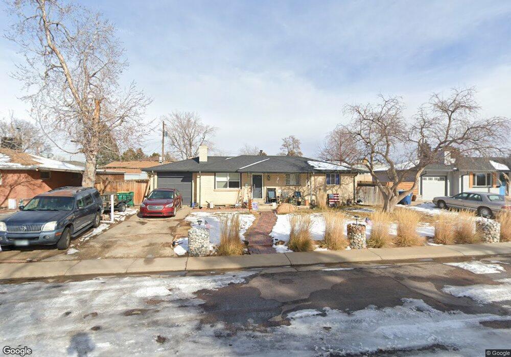
1961 Sherrelwood Cir Denver, CO 80221
Sherrelwood NeighborhoodEstimated Value: $421,336 - $504,000
3
Beds
2
Baths
1,050
Sq Ft
$452/Sq Ft
Est. Value
About This Home
This home is located at 1961 Sherrelwood Cir, Denver, CO 80221 and is currently estimated at $474,834, approximately $452 per square foot. 1961 Sherrelwood Cir is a home located in Adams County with nearby schools including Metropolitan Arts Academy, Iver C. Ranum Middle School, and Westminster High School.
Ownership History
Date
Name
Owned For
Owner Type
Purchase Details
Closed on
Dec 6, 2010
Sold by
Booco Patsy A
Bought by
Clouse David N and Booco Patsy A
Current Estimated Value
Purchase Details
Closed on
Jan 6, 2004
Sold by
Booco Patsy A and Clouse David N
Bought by
Booco Patsy A
Purchase Details
Closed on
Apr 30, 1996
Sold by
Booco Patsy A
Bought by
Clouse David N and Booco Patsy A
Home Financials for this Owner
Home Financials are based on the most recent Mortgage that was taken out on this home.
Original Mortgage
$25,000
Interest Rate
7.74%
Purchase Details
Closed on
Jul 7, 1993
Create a Home Valuation Report for This Property
The Home Valuation Report is an in-depth analysis detailing your home's value as well as a comparison with similar homes in the area
Home Values in the Area
Average Home Value in this Area
Purchase History
| Date | Buyer | Sale Price | Title Company |
|---|---|---|---|
| Clouse David N | -- | Land Title Guarantee Company | |
| Booco Patsy A | -- | Placer Title Company | |
| Clouse David N | -- | -- | |
| -- | $72,000 | -- |
Source: Public Records
Mortgage History
| Date | Status | Borrower | Loan Amount |
|---|---|---|---|
| Closed | Clouse David N | $25,000 |
Source: Public Records
Tax History Compared to Growth
Tax History
| Year | Tax Paid | Tax Assessment Tax Assessment Total Assessment is a certain percentage of the fair market value that is determined by local assessors to be the total taxable value of land and additions on the property. | Land | Improvement |
|---|---|---|---|---|
| 2024 | $3,097 | $27,250 | $5,500 | $21,750 |
| 2023 | $3,080 | $31,110 | $5,610 | $25,500 |
| 2022 | $2,885 | $24,240 | $5,770 | $18,470 |
| 2021 | $2,951 | $24,240 | $5,770 | $18,470 |
| 2020 | $2,805 | $23,460 | $5,930 | $17,530 |
| 2019 | $2,798 | $23,460 | $5,930 | $17,530 |
| 2018 | $2,249 | $18,750 | $5,400 | $13,350 |
| 2017 | $1,965 | $18,750 | $5,400 | $13,350 |
| 2016 | $1,573 | $14,240 | $2,950 | $11,290 |
| 2015 | $1,571 | $14,240 | $2,950 | $11,290 |
| 2014 | $1,514 | $13,110 | $2,390 | $10,720 |
Source: Public Records
Map
Nearby Homes
- 7918 Tejon St
- 8188 Pecos Way
- 7875 Cyd Dr
- 8247 Vanguard Dr
- 7956 Osage St
- 7820 Tejon St
- 2200 W 82nd Place
- 7819 Tejon St
- 2420 W 80th Ave
- 2420 W 82nd Place Unit F
- 1390 W 78th Cir
- 7973 Greenwood Blvd
- 7898 Applewood Ln
- 1321 Marigold Dr
- 2430 W 82nd Place Unit 2F
- 8330 Zuni St Unit 209
- 8330 Zuni St Unit 212
- 8330 Zuni St Unit 101
- 8330 Zuni St Unit 109
- 8330 Zuni St Unit 117
- 1981 Sherrelwood Cir
- 1940 Sherrelwood Dr
- 1960 Sherrelwood Dr
- 1920 Sherrelwood Dr
- 2021 Sherrelwood Cir
- 1921 Sherrelwood Cir
- 1921 Sherrelwood Dr
- 1960 Sherrelwood Cir
- 1921 Sherrelwood Cir
- 1980 Sherrelwood Cir
- 1980 Sherrelwood Dr
- 1940 Sherrelwood Cir
- 1910 Sherrelwood Cir
- 1910 Sherrelwood Dr
- 2041 Sherrelwood Cir
- 2000 Sherrelwood Cir
- 1920 Sherrelwood Cir
- 1919 Sherrelwood Dr
- 1901 Sherrelwood Dr
- 1990 Sherrelwood Dr