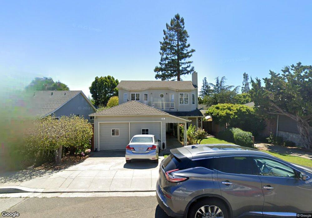
1963 Birch Ave San Carlos, CA 94070
Howard Park NeighborhoodEstimated Value: $2,261,000 - $3,138,000
3
Beds
3
Baths
2,100
Sq Ft
$1,288/Sq Ft
Est. Value
About This Home
This home is located at 1963 Birch Ave, San Carlos, CA 94070 and is currently estimated at $2,704,528, approximately $1,287 per square foot. 1963 Birch Ave is a home located in San Mateo County with nearby schools including Brittan Acres Elementary School, Central Middle School, and Sequoia High School.
Ownership History
Date
Name
Owned For
Owner Type
Purchase Details
Closed on
Dec 2, 2014
Sold by
Thom Christopher A and Thom Ana Cecilia
Bought by
Thom Family Trust and Thom Ana Cecilia
Current Estimated Value
Purchase Details
Closed on
Aug 12, 1999
Sold by
Sanford Thomas K and Sanford Jane M
Bought by
Thom Christopher A and Thom Ana C
Home Financials for this Owner
Home Financials are based on the most recent Mortgage that was taken out on this home.
Original Mortgage
$468,000
Outstanding Balance
$128,926
Interest Rate
7.12%
Estimated Equity
$2,575,602
Purchase Details
Closed on
Jul 3, 1996
Sold by
Keeler Grant J
Bought by
Sanford Thomas K and Jane Sanford M
Home Financials for this Owner
Home Financials are based on the most recent Mortgage that was taken out on this home.
Original Mortgage
$365,000
Interest Rate
8.03%
Create a Home Valuation Report for This Property
The Home Valuation Report is an in-depth analysis detailing your home's value as well as a comparison with similar homes in the area
Home Values in the Area
Average Home Value in this Area
Purchase History
| Date | Buyer | Sale Price | Title Company |
|---|---|---|---|
| Thom Family Trust | -- | None Available | |
| Thom Christopher A | -- | None Available | |
| Thom Christopher A | $585,000 | Fidelity National Title Co | |
| Sanford Thomas K | $467,500 | Chicago Title Co |
Source: Public Records
Mortgage History
| Date | Status | Borrower | Loan Amount |
|---|---|---|---|
| Open | Thom Christopher A | $468,000 | |
| Previous Owner | Sanford Thomas K | $365,000 |
Source: Public Records
Tax History
| Year | Tax Paid | Tax Assessment Tax Assessment Total Assessment is a certain percentage of the fair market value that is determined by local assessors to be the total taxable value of land and additions on the property. | Land | Improvement |
|---|---|---|---|---|
| 2025 | $11,791 | $899,120 | $449,560 | $449,560 |
| 2023 | $11,791 | $864,208 | $432,104 | $432,104 |
| 2022 | $11,112 | $847,264 | $423,632 | $423,632 |
| 2021 | $10,948 | $830,652 | $415,326 | $415,326 |
| 2020 | $10,819 | $822,136 | $411,068 | $411,068 |
| 2019 | $10,603 | $806,016 | $403,008 | $403,008 |
| 2018 | $10,323 | $790,212 | $395,106 | $395,106 |
| 2017 | $10,181 | $774,718 | $387,359 | $387,359 |
| 2016 | $9,960 | $759,528 | $379,764 | $379,764 |
| 2015 | $9,927 | $748,120 | $374,060 | $374,060 |
| 2014 | $9,534 | $733,466 | $366,733 | $366,733 |
Source: Public Records
Map
Nearby Homes
- 2258 Howard Ave
- 230 Rockridge Rd
- 1046 Lupin Way
- 926 Rosewood Ave
- 2308 Howard Ave
- 1440 Howard Ave
- 1388 Woodland Ave
- 754 Cordilleras Ave
- 836 Bauer Ct
- 793 Elm St Unit 17
- 728 Elm St Unit 205
- 663 Prospect St
- 1536 Cherry St Unit B
- 987 Laurel St
- 1385 Elm St
- 61 Hilltop Dr
- 39 Madera Ave
- 633 Elm St Unit 406
- 65 Madera Ave
- 2084 Saint Francis Way
- 1969 Birch Ave
- 1957 Birch Ave
- 1975 Birch Ave
- 1951 Birch Ave
- 1962 Eucalyptus Ave
- 1968 Eucalyptus Ave
- 1950 Eucalyptus Ave
- 1974 Eucalyptus Ave
- 1981 Birch Ave
- 1945 Birch Ave
- 1962 Birch Ave
- 1956 Birch Ave
- 1968 Birch Ave
- 1950 Birch Ave
- 1944 Eucalyptus Ave
- 1980 Eucalyptus Ave
- 1974 Birch Ave
- 1939 Birch Ave
- 1944 Birch Ave
- 977 Cordilleras Ave
Your Personal Tour Guide
Ask me questions while you tour the home.