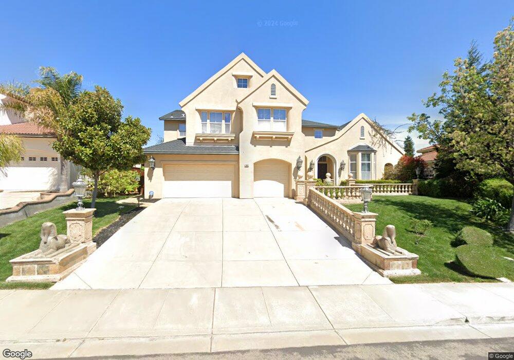
1963 Colosseum Way Antioch, CA 94531
Lone Tree Valley NeighborhoodEstimated Value: $889,000 - $1,122,000
5
Beds
4
Baths
3,883
Sq Ft
$252/Sq Ft
Est. Value
About This Home
This home is located at 1963 Colosseum Way, Antioch, CA 94531 and is currently estimated at $976,827, approximately $251 per square foot. 1963 Colosseum Way is a home located in Contra Costa County with nearby schools including Lone Tree Elementary School, Dallas Ranch Middle School, and Deer Valley High School.
Ownership History
Date
Name
Owned For
Owner Type
Purchase Details
Closed on
Jul 8, 2003
Sold by
Black Diamond Knolls Ltd
Bought by
Maxwell Anastasia M
Current Estimated Value
Home Financials for this Owner
Home Financials are based on the most recent Mortgage that was taken out on this home.
Original Mortgage
$492,870
Outstanding Balance
$207,806
Interest Rate
5.15%
Mortgage Type
Credit Line Revolving
Estimated Equity
$769,021
Purchase Details
Closed on
Oct 16, 2002
Sold by
South Terra Corp
Bought by
Black Diamond Knolls Ltd
Create a Home Valuation Report for This Property
The Home Valuation Report is an in-depth analysis detailing your home's value as well as a comparison with similar homes in the area
Home Values in the Area
Average Home Value in this Area
Purchase History
| Date | Buyer | Sale Price | Title Company |
|---|---|---|---|
| Maxwell Anastasia M | $548,000 | Old Republic Title | |
| Black Diamond Knolls Ltd | -- | Old Republic Title Company |
Source: Public Records
Mortgage History
| Date | Status | Borrower | Loan Amount |
|---|---|---|---|
| Open | Maxwell Anastasia M | $492,870 |
Source: Public Records
Tax History Compared to Growth
Tax History
| Year | Tax Paid | Tax Assessment Tax Assessment Total Assessment is a certain percentage of the fair market value that is determined by local assessors to be the total taxable value of land and additions on the property. | Land | Improvement |
|---|---|---|---|---|
| 2025 | $9,216 | $828,572 | $164,206 | $664,366 |
| 2024 | $8,891 | $812,327 | $160,987 | $651,340 |
| 2023 | $8,891 | $796,400 | $157,831 | $638,569 |
| 2022 | $8,748 | $780,786 | $154,737 | $626,049 |
| 2021 | $7,819 | $700,000 | $138,727 | $561,273 |
| 2019 | $7,444 | $658,000 | $130,403 | $527,597 |
| 2018 | $7,251 | $653,500 | $129,512 | $523,988 |
| 2017 | $6,638 | $594,500 | $117,819 | $476,681 |
| 2016 | $6,234 | $557,500 | $110,487 | $447,013 |
| 2015 | $6,113 | $510,000 | $101,073 | $408,927 |
| 2014 | $7,112 | $501,000 | $99,290 | $401,710 |
Source: Public Records
Map
Nearby Homes
- 1964 Finger Peak Way
- 5488 Southwood Ct
- 1333 Mokelumne Dr
- 5448 Southwood Way
- 5243 Delta View Way
- 2401 Silveria Way
- 4604 Coal Hill Place
- 1879 Mount Conness Way
- 1256 Mokelumne Ct
- 2344 Forty Niner Ct
- 1928 Badger Pass Way
- 2498 Taylor Way
- 2510 Vallecito Way
- 2721 Vallejo Ct
- 5106 Watkings Way
- 1157 Rockspring Way
- 5023 Vesteny Ct
- 2201 Mark Twain Dr
- 1525 Barkley Mountain Way
- 4959 Star Mine Ct
- 1967 Colosseum Way
- 1959 Colosseum Way
- 1964 Mokelumne Dr
- 1960 Mokelumne Dr
- 1971 Colosseum Way
- 1968 Mokelumne Dr
- 1956 Mokelumne Dr
- 1961 Hull Mountain Ct
- 1963 Hull Mountain Ct
- 1960 Mount Henry Ct
- 1972 Mokelumne Dr
- 1952 Mokelumne Dr
- 1975 Colosseum Way
- 1980 Mount Henry Ct
- 1962 Windy Peak Ct
- 1962 Mount Henry Ct
- 1976 Mokelumne Dr
- 1948 Mokelumne Dr
- 1965 Hull Mountain Ct
- 1979 Colosseum Way