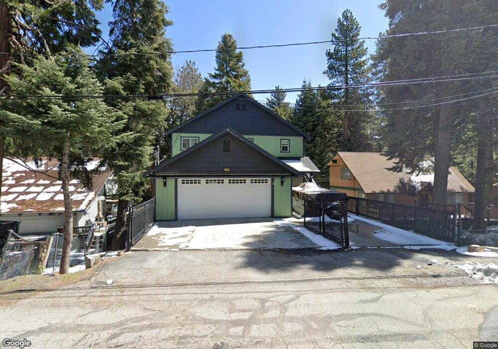
1965 Fernside Dr Running Springs, CA 92382
Estimated Value: $471,218 - $638,000
About This Home
This home is located at 1965 Fernside Dr, Running Springs, CA 92382 and is currently estimated at $549,305, approximately $281 per square foot. 1965 Fernside Dr is a home located in San Bernardino County with nearby schools including Charles Hoffman Elementary School, Mary P. Henck Intermediate School, and Rim Of The World Senior High School.
Ownership History
We collect this data history from publicly available records. To have your information removed, we recommend requesting removal directly through your county’s website.
Purchase Details
Purchase Details
Home Financials for this Owner
Home Financials are based on the most recent Mortgage that was taken out on this home.Purchase Details
Purchase Details
Home Financials for this Owner
Home Financials are based on the most recent Mortgage that was taken out on this home.Purchase Details
Home Financials for this Owner
Home Financials are based on the most recent Mortgage that was taken out on this home.Purchase Details
Purchase Details
Home Values in the Area
Average Home Value in this Area
Purchase History
We collect this data history from publicly available records. To have your information removed, we recommend requesting removal directly through your county’s website.
| Date | Buyer | Sale Price | Title Company |
|---|---|---|---|
| -- | None Available | ||
| $239,000 | First American Title Company | ||
| $248,000 | Accommodation | ||
| $485,000 | Commonwealth Land Title | ||
| -- | Commonwealth | ||
| -- | None Available | ||
| -- | None Available | ||
| $23,500 | First American Dg | ||
| -- | -- |
Mortgage History
We collect this data history from publicly available records. To have your information removed, we recommend requesting removal directly through your county’s website.
| Date | Status | Borrower | Loan Amount |
|---|---|---|---|
| Open | $217,788 | ||
| Previous Owner | $436,500 |
Tax History
We collect this data history from publicly available records. To have your information removed, we recommend requesting removal directly through your county’s website.
| Year | Tax Paid | Tax Assessment Tax Assessment Total Assessment is a certain percentage of the fair market value that is determined by local assessors to be the total taxable value of land and additions on the property. | Land | Improvement |
|---|---|---|---|---|
| 2025 | $3,886 | $308,505 | $45,178 | $263,327 |
| 2024 | $3,750 | $302,456 | $44,292 | $258,164 |
| 2023 | $3,706 | $296,526 | $43,424 | $253,102 |
| 2022 | $3,634 | $290,712 | $42,573 | $248,139 |
| 2021 | $3,593 | $285,012 | $41,738 | $243,274 |
| 2020 | $3,592 | $282,090 | $41,310 | $240,780 |
| 2019 | $3,501 | $301,559 | $40,500 | $261,059 |
| 2018 | $3,307 | $271,137 | $39,706 | $231,431 |
| 2017 | $3,246 | $265,820 | $38,927 | $226,893 |
| 2016 | $3,146 | $260,608 | $38,164 | $222,444 |
| 2015 | $3,111 | $256,694 | $37,591 | $219,103 |
| 2014 | $3,059 | $251,666 | $36,855 | $214,811 |
Map
- 31435 Oakleaf Dr
- 31345 Cedarwood Dr
- 31466 Onacrest Dr
- 31384 Onacrest Dr
- 31530 Onacrest Dr
- 31496 Circle View Dr
- 31194 Outer Highway 18 N
- 31162 All View Dr
- 2458 Spring Oak Dr
- 2402 Spring Oak Dr
- 2254 Spring Oak Dr
- 31144 All View Dr
- 2378 Rim of The World Dr
- 2343 Spring Oak Dr
- 2371 Spring Oak Dr
- 2379 Spring Oak Dr
- 31661 Wagon Wheel Dr
- 31041 Wild Oak Dr
- 31701 Christmas Tree Ln
- 2011 Nob Hill Dr
- 1955 Fernside Dr
- 1997 Fernside Rd
- 1997 Fernside Dr
- 1989 Fernside Rd
- 31445 Oakleaf Dr
- 31446 Oakleaf Dr
- 2003 Fernside Dr
- 1977 Fernside Rd
- 31440 Oakleaf Dr
- 2013 Fernside Dr
- 1990 Wilderness Rd
- 31430 Oakleaf Dr
- 31440 Pinehurst Dr
- 1962 Fernside Dr
- 2010 Wilderness Rd
- 2000 Wilderness Rd
- 1980 Wilderness Rd
- 31450 Pinehurst Dr
- 31425 Oakleaf Dr
- 1970 Wilderness Rd
Ask me questions while you tour the home.