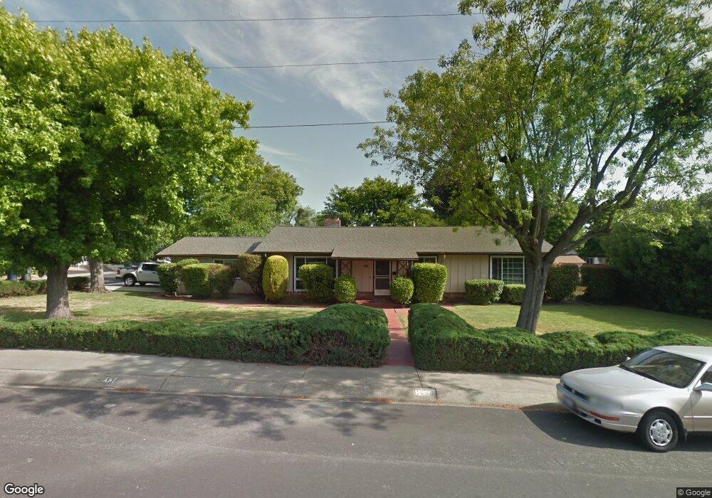
1969 Westover Dr Pleasant Hill, CA 94523
Estimated Value: $998,995 - $1,224,000
3
Beds
2
Baths
1,780
Sq Ft
$630/Sq Ft
Est. Value
About This Home
This home is located at 1969 Westover Dr, Pleasant Hill, CA 94523 and is currently estimated at $1,121,499, approximately $630 per square foot. 1969 Westover Dr is a home located in Contra Costa County with nearby schools including Strandwood Elementary School, Pleasant Hill Middle School, and College Park High School.
Ownership History
Date
Name
Owned For
Owner Type
Purchase Details
Closed on
Dec 9, 2014
Sold by
Briggs Guy
Bought by
Briggs Guy
Current Estimated Value
Purchase Details
Closed on
Jul 3, 2014
Sold by
Briggs Guy
Bought by
Briggs Guy
Home Financials for this Owner
Home Financials are based on the most recent Mortgage that was taken out on this home.
Original Mortgage
$105,000
Interest Rate
4.1%
Mortgage Type
New Conventional
Purchase Details
Closed on
Jun 6, 2014
Sold by
Briggs Guy and Thomas Gayle
Bought by
Briggs Guy
Home Financials for this Owner
Home Financials are based on the most recent Mortgage that was taken out on this home.
Original Mortgage
$105,000
Interest Rate
4.1%
Mortgage Type
New Conventional
Purchase Details
Closed on
Nov 16, 1994
Sold by
Briggs Robert A and Briggs Mary Alyce
Bought by
Briggs Robert A and Briggs Mary Alyce
Create a Home Valuation Report for This Property
The Home Valuation Report is an in-depth analysis detailing your home's value as well as a comparison with similar homes in the area
Home Values in the Area
Average Home Value in this Area
Purchase History
| Date | Buyer | Sale Price | Title Company |
|---|---|---|---|
| Briggs Guy | -- | None Available | |
| Briggs Guy | -- | First American Title | |
| Briggs Guy | -- | None Available | |
| Briggs Robert A | -- | -- |
Source: Public Records
Mortgage History
| Date | Status | Borrower | Loan Amount |
|---|---|---|---|
| Closed | Briggs Guy | $105,000 |
Source: Public Records
Tax History Compared to Growth
Tax History
| Year | Tax Paid | Tax Assessment Tax Assessment Total Assessment is a certain percentage of the fair market value that is determined by local assessors to be the total taxable value of land and additions on the property. | Land | Improvement |
|---|---|---|---|---|
| 2025 | $2,593 | $168,205 | $79,165 | $89,040 |
| 2024 | $2,538 | $164,908 | $77,613 | $87,295 |
| 2023 | $2,538 | $161,676 | $76,092 | $85,584 |
| 2022 | $2,515 | $158,506 | $74,600 | $83,906 |
| 2021 | $2,450 | $155,399 | $73,138 | $82,261 |
| 2019 | $2,362 | $150,792 | $70,970 | $79,822 |
| 2018 | $2,273 | $147,836 | $69,579 | $78,257 |
| 2017 | $2,190 | $144,938 | $68,215 | $76,723 |
| 2016 | $2,186 | $142,097 | $66,878 | $75,219 |
| 2015 | $2,081 | $139,964 | $65,874 | $74,090 |
| 2014 | $2,116 | $86,824 | $27,454 | $59,370 |
Source: Public Records
Map
Nearby Homes
- 589 Maureen Ln
- 500 Creekside Rd
- 2422 Pleasant Hill Rd Unit 6
- 112 Lockwood Ln
- 2420 Pleasant Hill Rd Unit 4
- 1919 Helen Rd Unit 2
- 309 Sunset Rd
- 576 Best Rd
- 498 Wilbur Dr
- 505 Tananger Heights Ct
- 5 Harwich Walk Unit 55
- 900 Kimberly Cir
- 25 Brandon Rd
- 368 Grapevine Place
- 2049 Elinora Dr
- 277 Gloria Dr
- 808 Grayson Rd
- 58 Ramsgate Ln
- 117 Haven Cir
- 109 Haven Cir
- 561 Maureen Ln
- 1965 Westover Dr
- 569 Maureen Ln
- 1925 Marguerite Ave
- 557 Maureen Ln
- 1966 Westover Dr
- 564 Maureen Ln
- 560 Maureen Ln
- 573 Maureen Ln
- 1921 Marguerite Ave
- 553 Maureen Ln
- 570 Maureen Ln
- 556 Maureen Ln
- 1928 Marguerite Ave
- 1962 Westover Dr
- 1924 Marguerite Ave
- 574 Maureen Ln
- 577 Maureen Ln
- 552 Maureen Ln
- 1917 Marguerite Ave