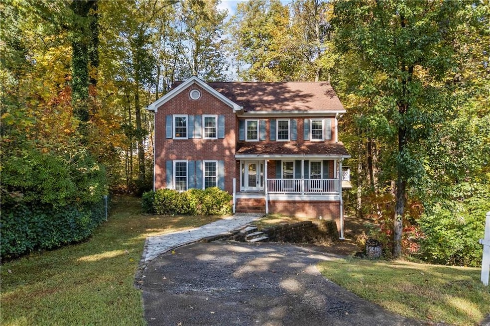


1970 Sturbridge Ln Unit 1 Buford, GA 30519
Estimated payment $2,732/month
Highlights
- Wine Cellar
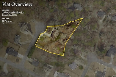
- 0.72 Acre Lot
- Rural View
- Harmony Elementary School Rated A-
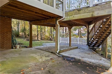
- Deck
- Oversized primary bedroom
About This Home
Tucked away in the desirable Brentwood Hills community of Buford, Georgia, this beautifully maintained 3-bedroom, 2.5-bath home combines comfort, style, and peace of mind. No HOA! Thoughtful updates include a 5-year-old water heater, a 3-year-old HVAC system, and brand-new windows and exterior doors throughout. The inviting family room, complete with a cozy fireplace, opens seamlessly to the eat-in kitchen, creating the perfect space for everyday living or entertaining guests. Inside, new luxury vinyl plank flooring enhances the main level, while upstairs offers three spacious bedrooms, including a renovated primary suite with a refreshed en suite bath. Step outside to enjoy a screened-in porch that leads to a newly built multi-level deck—ideal for relaxing or hosting gatherings in your private backyard oasis. Located in a friendly, established neighborhood close to top-rated schools, parks, and shopping—including the Mall of Georgia, this home delivers the best of suburban serenity and modern convenience.
Home Details
Home Type
- Single Family
Est. Annual Taxes
- $4,362
Year Built
- Built in 1986
Lot Details
- 0.72 Acre Lot
- Lot Dimensions are 47x174x40x39x52x102
- Private Entrance
- Landscaped
- Back and Front Yard
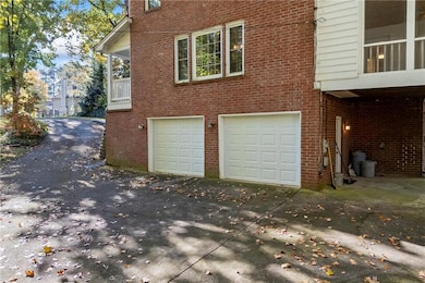
Parking
- 2 Car Garage
- Side Facing Garage
- Drive Under Main Level
Property Views
- Rural
- Neighborhood
Home Design
- Traditional Architecture
- Composition Roof
- Four Sided Brick Exterior Elevation
- Concrete Perimeter Foundation
Interior Spaces
- 2,458 Sq Ft Home
- 2-Story Property
- Dry Bar
- Crown Molding
- Ceiling Fan
- Factory Built Fireplace
- Insulated Windows
- Entrance Foyer
- Wine Cellar
- Family Room with Fireplace
- Formal Dining Room
- Screened Porch
- Unfinished Basement
- Walk-Out Basement
- Pull Down Stairs to Attic
- Fire and Smoke Detector
Kitchen
- Eat-In Kitchen
- Gas Range
- Range Hood
- Dishwasher
- Solid Surface Countertops
- Wood Stained Kitchen Cabinets
Flooring
- Carpet
- Ceramic Tile
- Luxury Vinyl Tile
Bedrooms and Bathrooms
- 3 Bedrooms
- Oversized primary bedroom
- Walk-In Closet
- Dual Vanity Sinks in Primary Bathroom
- Shower Only
Laundry
- Laundry Room
- Laundry on main level
Outdoor Features
- Deck
- Patio
- Rain Gutters
Schools
- Harmony - Gwinnett Elementary School
- Jones Middle School
- Seckinger High School
Utilities
- Central Air
- Heating System Uses Natural Gas
- 220 Volts
- Gas Water Heater
- Septic Tank
- High Speed Internet
- Cable TV Available
Community Details
- Brentwood Hills Subdivision
Listing and Financial Details
- Assessor Parcel Number R7186 070
Map
Home Values in the Area
Average Home Value in this Area
Tax History
| Year | Tax Paid | Tax Assessment Tax Assessment Total Assessment is a certain percentage of the fair market value that is determined by local assessors to be the total taxable value of land and additions on the property. | Land | Improvement |
|---|---|---|---|---|
| 2025 | $1,161 | $181,040 | $40,000 | $141,040 |
| 2024 | $4,362 | $156,120 | $39,200 | $116,920 |
| 2023 | $4,362 | $176,480 | $39,200 | $137,280 |
| 2022 | $4,071 | $143,840 | $27,960 | $115,880 |
| 2021 | $3,437 | $110,480 | $27,960 | $82,520 |
| 2020 | $3,253 | $100,840 | $23,840 | $77,000 |
| 2019 | $3,170 | $100,840 | $23,840 | $77,000 |
| 2018 | $3,000 | $92,880 | $18,400 | $74,480 |
| 2016 | $2,853 | $85,040 | $14,800 | $70,240 |
| 2015 | $2,878 | $85,040 | $14,800 | $70,240 |
| 2014 | -- | $73,200 | $14,800 | $58,400 |
Property History
| Date | Event | Price | List to Sale | Price per Sq Ft |
|---|---|---|---|---|
| 11/06/2025 11/06/25 | For Sale | $449,900 | -- | $183 / Sq Ft |
Purchase History
| Date | Type | Sale Price | Title Company |
|---|---|---|---|
| Deed | $172,000 | -- | |
| Deed | $71,000 | -- | |
| Deed | $71,000 | -- |
Mortgage History
| Date | Status | Loan Amount | Loan Type |
|---|---|---|---|
| Open | $137,600 | New Conventional |
Source: First Multiple Listing Service (FMLS)
MLS Number: 7676973
APN: 7-186-070
Disclaimer: Certain information contained herein is derived from information provided by parties other than Homes.com. All information provided is deemed reliable, but is not guaranteed to be accurate and should be independently verified.
![]() Listings identified with the FMLS IDX logo come from FMLS and are held by brokerage firms other than the owner of this website. The listing brokerage is identified in any listing details. Information is deemed reliable but is not guaranteed. If you believe any FMLS listing contains material that infringes your copyrighted work please visit www.fmls.com/dmca to review our DMCA policy and learn how to submit a takedown request. © 2025 First Multiple Listing Service, Inc.
Listings identified with the FMLS IDX logo come from FMLS and are held by brokerage firms other than the owner of this website. The listing brokerage is identified in any listing details. Information is deemed reliable but is not guaranteed. If you believe any FMLS listing contains material that infringes your copyrighted work please visit www.fmls.com/dmca to review our DMCA policy and learn how to submit a takedown request. © 2025 First Multiple Listing Service, Inc.
- 3476 Harvest Ridge Ln
- 3410 Coles Creek Dr
- 2140 Harvest Ridge Cir
- 3534 Fallen Oak Ln
- 2040 Harvest Ridge Cir NE
- 2040 Harvest Ridge Cir
- 3573 Fallen Oak Dr
- 2183 Ivy Crest Dr
- 3684 Heritage Crest Pkwy
- 2182 Misty Brook Ct
- 2148 Splitrail Trail
- 4152 Adler Cir
- 3962 Adler Cir Unit 7
- 3962 Adler Cir
- 4152 Adler Cir Unit 42
- 4202 Adler Cir Unit 47
- 4202 Adler Cir
- 2272 Misty Brook Ct
- 2320 Copper Trail Ln
- 2262 Silver Fox Ln
- 3427 Harvest Ridge Ln NE
- 3525 Fallen Oak Ln
- 2279 White Alder Dr
- 3550 Red Willow Ct
- 2328 White Alder Dr
- 2275 Copper Trail Ln
- 2214 Mill Garden Place
- 3179 Mill Springs Cir NE
- 3296 Mill Springs Cir
- 3194 Mill Springs Cir
- 3620 Knoll Crest Trail
- 3440 Kentwater Dr
- 3572 Brockenhurst Dr
- 2150 Spikerush Way
- 3025 Woodward Crossing Blvd
- 2344 Attewood Dr
- 2410 Chandler Grove Dr
- 3434 Ivy Farm Path
- 2620 Mall of Georgia Blvd
- 3490 Southpointe Hl Dr
