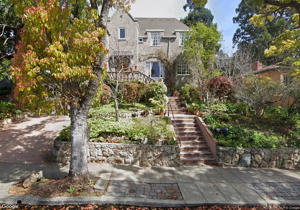
1975 Yosemite Rd Berkeley, CA 94707
Thousand Oaks NeighborhoodEstimated Value: $2,802,102 - $3,254,000
4
Beds
4
Baths
3,423
Sq Ft
$853/Sq Ft
Est. Value
About This Home
This home is located at 1975 Yosemite Rd, Berkeley, CA 94707 and is currently estimated at $2,919,526, approximately $852 per square foot. 1975 Yosemite Rd is a home located in Alameda County with nearby schools including Thousand Oaks Elementary School, Berkeley Arts Magnet at Whittier School, and Ruth Acty Elementary.
Ownership History
Date
Name
Owned For
Owner Type
Purchase Details
Closed on
Apr 3, 2024
Sold by
Skonberg-Hammond Family Trust and Hammond Jane Rebecca
Bought by
Skonberg-Hammond Family Trust and Hammond
Current Estimated Value
Purchase Details
Closed on
Apr 11, 2015
Sold by
Hammond Jane and Skonberg John
Bought by
Skonberg Hammond Family Trust
Create a Home Valuation Report for This Property
The Home Valuation Report is an in-depth analysis detailing your home's value as well as a comparison with similar homes in the area
Home Values in the Area
Average Home Value in this Area
Purchase History
| Date | Buyer | Sale Price | Title Company |
|---|---|---|---|
| Skonberg-Hammond Family Trust | -- | None Listed On Document | |
| Skonberg Hammond Family Trust | -- | None Available |
Source: Public Records
Tax History
| Year | Tax Paid | Tax Assessment Tax Assessment Total Assessment is a certain percentage of the fair market value that is determined by local assessors to be the total taxable value of land and additions on the property. | Land | Improvement |
|---|---|---|---|---|
| 2025 | $19,681 | $1,084,175 | $301,367 | $789,808 |
| 2024 | $19,681 | $1,062,783 | $295,459 | $774,324 |
| 2023 | $19,182 | $1,048,808 | $289,666 | $759,142 |
| 2022 | $18,706 | $1,021,246 | $283,987 | $744,259 |
| 2021 | $18,712 | $1,001,086 | $278,419 | $729,667 |
| 2020 | $17,529 | $997,753 | $275,565 | $722,188 |
| 2019 | $16,646 | $978,191 | $270,162 | $708,029 |
| 2018 | $16,320 | $959,014 | $264,866 | $694,148 |
| 2017 | $15,766 | $940,214 | $259,674 | $680,540 |
| 2016 | $15,133 | $921,781 | $254,583 | $667,198 |
| 2015 | $14,906 | $907,935 | $250,759 | $657,176 |
| 2014 | -- | $890,153 | $245,848 | $644,305 |
Source: Public Records
Map
Nearby Homes
- 1983 Yosemite Rd
- 770 Santa Barbara Rd
- 549 Santa Barbara Rd
- 483 Boynton Ave
- 826 Indian Rock Ave
- 614 Cragmont Ave
- 479 Kentucky Ave
- 385 Vermont Ave
- 1563 Thousand Oaks Blvd
- 582 Euclid Ave
- 225 Arlington Ave
- 46 Ardmore Rd
- 255 Stanford Ave
- 201 Amherst Ave
- 265 Purdue Ave
- 1024 Miller Ave
- 935 Grizzly Peak Blvd
- 982 Grizzly Peak Blvd
- 720 Key Route Blvd
- 1106 Cragmont Ave
- 1967 Yosemite Rd
- 1977 Yosemite Rd
- 762 Arlington Ave
- 768 Arlington Ave
- 754 Arlington Ave
- 1963 Yosemite Rd
- 1968 Yosemite Rd
- 1966 Yosemite Rd
- 1972 Yosemite Rd
- 776 Arlington Ave
- 748 Arlington Ave
- 1962 Yosemite Rd
- 1957 Yosemite Rd
- 1978 Yosemite Rd
- 742 Arlington Ave
- 753 Contra Costa Ave
- 749 Contra Costa Ave
- 1982 Yosemite Rd
- 745 Contra Costa Ave
- 763 Contra Costa Ave
Your Personal Tour Guide
Ask me questions while you tour the home.