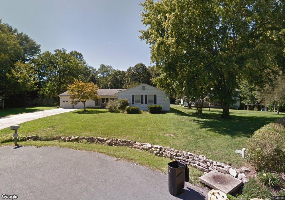
1976 Glencrest Ln Annapolis, MD 21401
Parole NeighborhoodEstimated Value: $545,000 - $647,000
--
Bed
2
Baths
2,148
Sq Ft
$280/Sq Ft
Est. Value
About This Home
This home is located at 1976 Glencrest Ln, Annapolis, MD 21401 and is currently estimated at $600,818, approximately $279 per square foot. 1976 Glencrest Ln is a home located in Anne Arundel County with nearby schools including Rolling Knolls Elementary School, Wiley H. Bates Middle School, and Annapolis High School.
Ownership History
Date
Name
Owned For
Owner Type
Purchase Details
Closed on
Dec 31, 2003
Sold by
Stefanowicz Michael J
Bought by
Ross Evangeline S and Ross Michael T
Current Estimated Value
Purchase Details
Closed on
Sep 5, 2001
Sold by
Nagel Norman M
Bought by
Stefanowicz Michael J
Purchase Details
Closed on
Oct 11, 1996
Sold by
Nagel Norman M
Bought by
Nagel Norman M and Nagel Betty L
Create a Home Valuation Report for This Property
The Home Valuation Report is an in-depth analysis detailing your home's value as well as a comparison with similar homes in the area
Home Values in the Area
Average Home Value in this Area
Purchase History
| Date | Buyer | Sale Price | Title Company |
|---|---|---|---|
| Ross Evangeline S | $319,900 | -- | |
| Stefanowicz Michael J | $230,000 | -- | |
| Nagel Norman M | -- | -- |
Source: Public Records
Tax History Compared to Growth
Tax History
| Year | Tax Paid | Tax Assessment Tax Assessment Total Assessment is a certain percentage of the fair market value that is determined by local assessors to be the total taxable value of land and additions on the property. | Land | Improvement |
|---|---|---|---|---|
| 2025 | $3,961 | $457,333 | -- | -- |
| 2024 | $3,961 | $427,867 | $0 | $0 |
| 2023 | $3,832 | $398,400 | $226,600 | $171,800 |
| 2022 | $3,591 | $395,300 | $0 | $0 |
| 2021 | $460 | $392,200 | $0 | $0 |
| 2020 | $3,438 | $389,100 | $226,600 | $162,500 |
| 2019 | $3,373 | $374,800 | $0 | $0 |
| 2018 | $460 | $360,500 | $0 | $0 |
| 2017 | $3,164 | $346,200 | $0 | $0 |
| 2016 | $460 | $341,100 | $0 | $0 |
| 2015 | $460 | $336,000 | $0 | $0 |
| 2014 | -- | $330,900 | $0 | $0 |
Source: Public Records
Map
Nearby Homes
- 524 Ridge Rd
- 2175 Glencrest Cir
- 2175
- 2175 Glencrest Circle - Taft Model
- 622 Sean Dr
- 1002 Covington Way
- 1737 Point no Point Dr
- 39 Oak Ct
- 553 Choptank Cove Ct
- 522 Epping Forest Rd
- 1634 Old Generals Hwy
- 1909 Eleanor Ct
- 1496 River Rd
- 1974 Scotts Crossing Way
- 524 Coover Rd
- 108 Harbour Heights Dr
- 2155 Scotts Crossing Ct Unit 303
- 208 Sellew Rd
- Plan 1 at Towne Row
- 2555 Riva Rd
- 627 Rolling Dale Rd
- 629 Rolling Dale Rd
- 1978 Glencrest Ln
- 1974 Glencrest Ln
- 1975 Glencrest Ln
- 584 Wayward Ct
- 1977 Glencrest Ln
- 625 Rolling Dale Rd
- 630 Rolling Dale Rd
- 582 Wayward Ct
- 1980 Glencrest Ln
- 628 Rolling Dale Rd
- 1976 Valley Rd
- 626 Rolling Dale Rd
- 1974 Valley Rd
- 586 Wayward Ct
- 1979 Glencrest Ln
- 1978 Valley Rd
- 623 Rolling Dale Rd
- 1982 Glencrest Ln