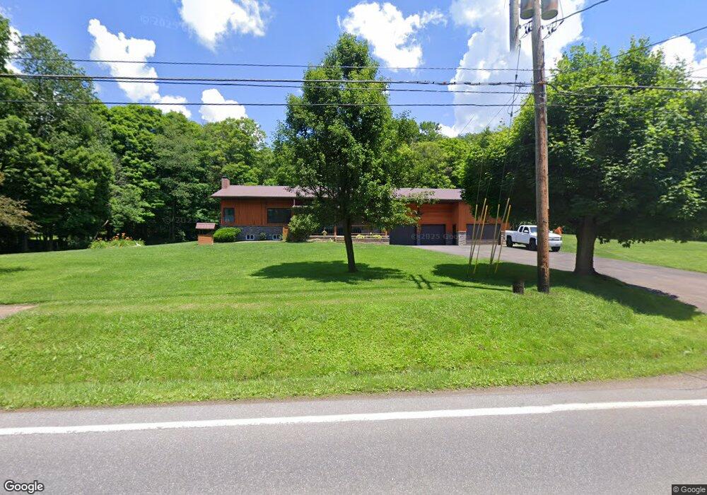
1976 Listonburg Rd Confluence, PA 15424
Estimated Value: $164,000 - $239,000
4
Beds
1
Bath
1,470
Sq Ft
$145/Sq Ft
Est. Value
About This Home
This home is located at 1976 Listonburg Rd, Confluence, PA 15424 and is currently estimated at $213,592, approximately $145 per square foot. 1976 Listonburg Rd is a home located in Somerset County with nearby schools including Turkeyfoot Valley Area Elementary School and Turkeyfoot Valley Area Junior/Senior High School.
Ownership History
Date
Name
Owned For
Owner Type
Purchase Details
Closed on
Jun 11, 2014
Sold by
Kemp James A and Kemp Lori A
Bought by
Rugg Herschel G and Rugg Charity L
Current Estimated Value
Purchase Details
Closed on
Jan 21, 2013
Sold by
Kemp James A and Kemp Lori A
Bought by
Kemp Lori A
Create a Home Valuation Report for This Property
The Home Valuation Report is an in-depth analysis detailing your home's value as well as a comparison with similar homes in the area
Home Values in the Area
Average Home Value in this Area
Purchase History
| Date | Buyer | Sale Price | Title Company |
|---|---|---|---|
| Rugg Herschel G | $30,000 | None Available | |
| Kemp Lori A | -- | None Available |
Source: Public Records
Tax History Compared to Growth
Tax History
| Year | Tax Paid | Tax Assessment Tax Assessment Total Assessment is a certain percentage of the fair market value that is determined by local assessors to be the total taxable value of land and additions on the property. | Land | Improvement |
|---|---|---|---|---|
| 2025 | $1,416 | $30,260 | $0 | $0 |
| 2024 | $1,416 | $30,260 | $0 | $0 |
| 2023 | $1,363 | $30,260 | $0 | $0 |
| 2022 | $1,327 | $30,260 | $0 | $0 |
| 2021 | $1,297 | $30,260 | $0 | $0 |
| 2020 | $1,297 | $30,260 | $0 | $0 |
| 2019 | $1,297 | $30,260 | $0 | $0 |
| 2018 | $1,284 | $30,260 | $5,850 | $24,410 |
| 2017 | $1,297 | $30,260 | $5,850 | $24,410 |
| 2016 | -- | $30,260 | $5,850 | $24,410 |
| 2015 | -- | $40,420 | $5,850 | $34,570 |
| 2014 | -- | $41,525 | $5,850 | $35,675 |
Source: Public Records
Map
Nearby Homes
- 0 Klondike Rd Unit 22177073
- 0 Klondike Rd Unit 22177082
- 0 Klondike Rd Unit 22177080
- 0 Klondike Rd Unit 22177074
- Coon Hollow Rd
- 0 Coon Hollow Rd
- 833 Oden St
- 631 Meyers St
- 626 Sterner St
- 734 Main St
- 280 Main St
- #5 & #7 Laurel Rd
- 230 Locust Rd
- 750 Lake Side Rd
- 100 First St
- 100 First Street Lot Unit WP001
- 0 Pullim Hollow Rd
- 0 Scenic Dr Unit MDGA2010242
- 249 State Line Dr
- 210 Lakeview Dr
- 1996 Listonburg Rd
- 106 Camp Ground Rd
- 1940 Listonburg Rd
- 2004 Listonburg Rd
- 2036 Listonburg Rd
- 141 Camp Ground Rd
- 2051 Listonburg Rd
- 2051 Listonburg Rd
- 1891 Listonburg Rd
- 1860 Listonburg Rd
- 1877 Listonburg Rd
- 141 Campround Rd
- 149 Camp Ground Rd
- 1861 Listonburg Rd
- 202 Camp Ground Rd
- 2092 Listonburg Rd
- 2092 Listonburg Rd
- 1844 Listonburg Rd
- 2851 Fort Hill Rd
- 1827 Listonburg Rd