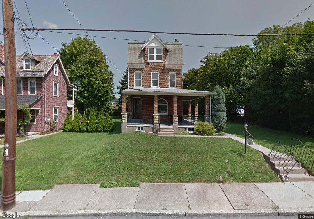
1977 S 5th St Unit 1981 Allentown, PA 18103
Southside NeighborhoodEstimated Value: $327,396
2
Beds
3
Baths
2,540
Sq Ft
$129/Sq Ft
Est. Value
About This Home
This home is located at 1977 S 5th St Unit 1981, Allentown, PA 18103 and is currently estimated at $327,396, approximately $128 per square foot. 1977 S 5th St Unit 1981 is a home located in Lehigh County with nearby schools including Hiram W Dodd Elementary School, South Mountain Middle School, and Louis E. Dieruff High School.
Ownership History
Date
Name
Owned For
Owner Type
Purchase Details
Closed on
Sep 17, 2024
Sold by
Borshansky Edward
Bought by
Aarpar Realty Inc
Current Estimated Value
Purchase Details
Closed on
Oct 31, 1983
Sold by
Uhl Henry G and Uhl Arlene A
Bought by
Lienhard Bernard J and Lienhard Ernestine E
Create a Home Valuation Report for This Property
The Home Valuation Report is an in-depth analysis detailing your home's value as well as a comparison with similar homes in the area
Home Values in the Area
Average Home Value in this Area
Purchase History
| Date | Buyer | Sale Price | Title Company |
|---|---|---|---|
| Aarpar Realty Inc | $315,000 | Keystone Premier Settlement Se | |
| Lienhard Bernard J | $69,000 | -- |
Source: Public Records
Tax History Compared to Growth
Tax History
| Year | Tax Paid | Tax Assessment Tax Assessment Total Assessment is a certain percentage of the fair market value that is determined by local assessors to be the total taxable value of land and additions on the property. | Land | Improvement |
|---|---|---|---|---|
| 2025 | $5,796 | $166,200 | $34,800 | $131,400 |
| 2024 | $5,796 | $166,200 | $34,800 | $131,400 |
| 2023 | $5,796 | $166,200 | $34,800 | $131,400 |
| 2022 | $5,606 | $166,200 | $131,400 | $34,800 |
| 2021 | $5,502 | $166,200 | $34,800 | $131,400 |
| 2020 | $5,369 | $166,200 | $34,800 | $131,400 |
| 2019 | $5,288 | $166,200 | $34,800 | $131,400 |
| 2018 | $4,880 | $166,200 | $34,800 | $131,400 |
| 2017 | $4,764 | $166,200 | $34,800 | $131,400 |
| 2016 | -- | $166,200 | $34,800 | $131,400 |
| 2015 | -- | $166,200 | $34,800 | $131,400 |
| 2014 | -- | $166,200 | $34,800 | $131,400 |
Source: Public Records
Map
Nearby Homes
- 206 208 W Emaus Ave
- 566 W Emaus Ave
- 566 588 W Emaus Ave
- 2347 S Law St Unit 2349
- 1852 S 2nd St
- 2416 S Alice St Unit 2418
- 148 W Brookdale St
- 203 W Brookdale St
- 2441 S 4th St
- 1831 S Church St
- 642 W Emaus Ave
- 102 W Brookdale St
- 2401 S Church St
- 135 W Wabash St
- 2413 S Church St
- 2429 S Front St
- 2421 S Wood St
- 316 W Mountain Rd
- 1865 Chapel Ave
- 121 Woodcrest Cir
- 1977 S 5th St
- 1977 S 5th St Unit 2
- 1985 S 5th St
- 1965 S 5th St Unit 1969
- 1974 S 5th St
- 1976 S 5th St
- 1971 S 5th St Unit 1975
- 1970 S 5th St
- 433 W Emaus Ave Unit REAR
- 1980 S 5th St
- 1982 S 5th St
- 1961 S 5th St
- 1972 S 5th St
- 1984 S 5th St
- 1968 S 5th St
- 1966 S 5th St
- 1957 S 5th St Unit 1959
- 1964 S 5th St
- 1988 S 5th St
- 1958 S 5th St