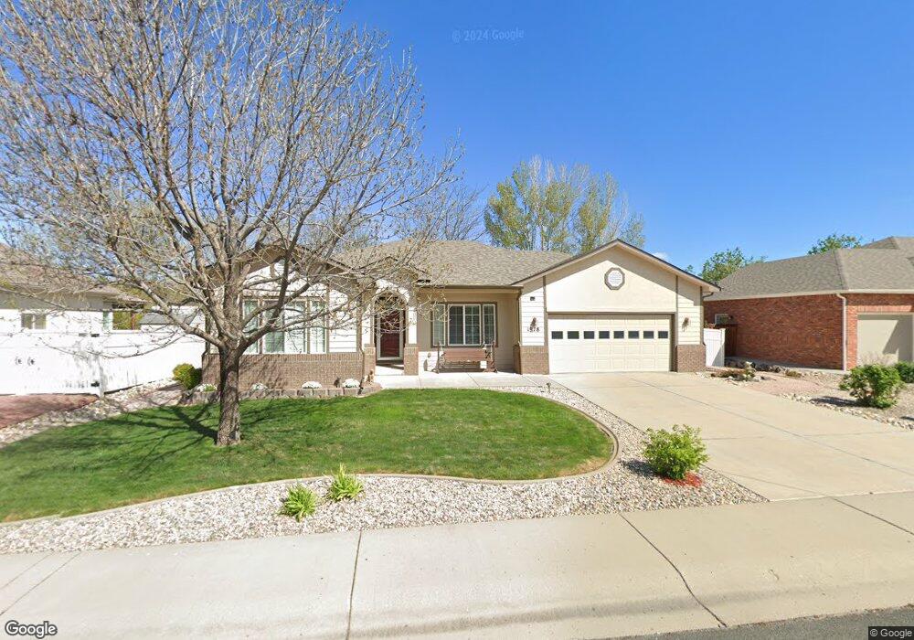
1978 Tincup Dr Loveland, CO 80538
Estimated Value: $650,000 - $778,000
4
Beds
3
Baths
3,200
Sq Ft
$219/Sq Ft
Est. Value
About This Home
This home is located at 1978 Tincup Dr, Loveland, CO 80538 and is currently estimated at $699,234, approximately $218 per square foot. 1978 Tincup Dr is a home located in Larimer County with nearby schools including Ponderosa Elementary School, Bill Reed Middle School, and Loveland High School.
Ownership History
Date
Name
Owned For
Owner Type
Purchase Details
Closed on
Apr 30, 2012
Sold by
Malmin Phyllis J
Bought by
Trout Thomas Lee and Trout Barbara Kay
Current Estimated Value
Purchase Details
Closed on
Aug 20, 2003
Sold by
Weinland Homes Inc
Bought by
Malmin William R and Malmin Phyllis J
Home Financials for this Owner
Home Financials are based on the most recent Mortgage that was taken out on this home.
Original Mortgage
$100,000
Interest Rate
5.51%
Mortgage Type
Purchase Money Mortgage
Create a Home Valuation Report for This Property
The Home Valuation Report is an in-depth analysis detailing your home's value as well as a comparison with similar homes in the area
Home Values in the Area
Average Home Value in this Area
Purchase History
| Date | Buyer | Sale Price | Title Company |
|---|---|---|---|
| Trout Thomas Lee | $320,000 | None Available | |
| Malmin William R | $267,803 | -- |
Source: Public Records
Mortgage History
| Date | Status | Borrower | Loan Amount |
|---|---|---|---|
| Previous Owner | Malmin William R | $100,000 |
Source: Public Records
Tax History Compared to Growth
Tax History
| Year | Tax Paid | Tax Assessment Tax Assessment Total Assessment is a certain percentage of the fair market value that is determined by local assessors to be the total taxable value of land and additions on the property. | Land | Improvement |
|---|---|---|---|---|
| 2025 | $2,588 | $42,813 | $11,390 | $31,423 |
| 2024 | $2,496 | $42,813 | $11,390 | $31,423 |
| 2022 | $2,474 | $31,087 | $6,255 | $24,832 |
| 2021 | $2,542 | $31,982 | $6,435 | $25,547 |
| 2020 | $2,542 | $31,975 | $6,435 | $25,540 |
| 2019 | $2,499 | $31,975 | $6,435 | $25,540 |
| 2018 | $2,522 | $30,643 | $6,480 | $24,163 |
| 2017 | $2,172 | $30,643 | $6,480 | $24,163 |
| 2016 | $2,043 | $27,860 | $5,811 | $22,049 |
| 2015 | $2,027 | $28,810 | $5,810 | $23,000 |
| 2014 | $1,846 | $24,550 | $5,010 | $19,540 |
Source: Public Records
Map
Nearby Homes
- 2002 Falls Ct
- 3363 Cuchara Ct
- 1942 Lakewood Dr
- 3625 Como Ct
- 1726 Kennedy Ave
- 2217 Durango Dr
- 2264 Durango Dr
- 2216 Durango Dr
- 1892 Gunnison Place
- 1870 Idalia Ct
- 4046 Crawford Ct
- 1304 Pine St
- 1682 Stove Prairie Cir
- 1670 Stove Prairie Cir
- 2467 Farisita Dr
- 3002 Ironton Dr
- Chelton Plan at Riano Ridge - The Grand Collection
- Stonehaven II Plan at Riano Ridge - The Grand Collection
- Aspen Plan at Riano Ridge - The Grand Collection
- 3021 Ironton Dr
- 1956 Tincup Dr
- 2000 Tincup Dr
- 1934 Tincup Dr
- 2024 Tincup Dr
- 1983 Tincup Dr
- 1961 Tincup Dr
- 2005 Tincup Dr
- 1925 Tincup Dr
- 1912 Tincup Dr
- 2058 Tincup Dr
- 2031 Tincup Dr
- 3426 Creede Ct
- 1979 Falls Ct
- 2057 Tincup Dr
- 1950 Creede Ave
- 3402 Creede Ct
- 1982 Creede Ave
- 1934 Creede Ave
- 1901 Falls Ct
- 1898 Tincup Ct