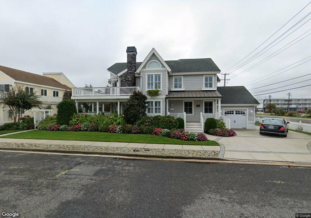
198 77th St Avalon, NJ 08202
Estimated Value: $3,726,309 - $4,543,000
Studio
--
Bath
2,672
Sq Ft
$1,576/Sq Ft
Est. Value
About This Home
This home is located at 198 77th St, Avalon, NJ 08202 and is currently estimated at $4,210,077, approximately $1,575 per square foot. 198 77th St is a home located in Cape May County with nearby schools including Avalon Elementary School.
Ownership History
Date
Name
Owned For
Owner Type
Purchase Details
Closed on
Sep 9, 2008
Sold by
Borough Of Avalon
Bought by
Leo P & Mary F Bangert Trust
Current Estimated Value
Home Financials for this Owner
Home Financials are based on the most recent Mortgage that was taken out on this home.
Original Mortgage
$1,100,000
Interest Rate
5.75%
Mortgage Type
Purchase Money Mortgage
Purchase Details
Closed on
Jul 25, 2008
Sold by
Tokarski Jean M and Dare Elizabeth A
Bought by
Mcdermott James and Mcdermott Eileen
Home Financials for this Owner
Home Financials are based on the most recent Mortgage that was taken out on this home.
Original Mortgage
$1,100,000
Interest Rate
5.75%
Mortgage Type
Purchase Money Mortgage
Create a Home Valuation Report for This Property
The Home Valuation Report is an in-depth analysis detailing your home's value as well as a comparison with similar homes in the area
Home Values in the Area
Average Home Value in this Area
Purchase History
| Date | Buyer | Sale Price | Title Company |
|---|---|---|---|
| Leo P & Mary F Bangert Trust | -- | None Available | |
| Mcdermott James | $2,100,000 | None Available |
Source: Public Records
Mortgage History
| Date | Status | Borrower | Loan Amount |
|---|---|---|---|
| Previous Owner | Mcdermott James | $1,100,000 |
Source: Public Records
Tax History
| Year | Tax Paid | Tax Assessment Tax Assessment Total Assessment is a certain percentage of the fair market value that is determined by local assessors to be the total taxable value of land and additions on the property. | Land | Improvement |
|---|---|---|---|---|
| 2025 | $14,285 | $2,326,600 | $1,775,000 | $551,600 |
| 2024 | $14,285 | $2,326,600 | $1,775,000 | $551,600 |
| 2023 | $14,169 | $2,326,600 | $1,775,000 | $551,600 |
| 2022 | $13,215 | $2,326,600 | $1,775,000 | $551,600 |
| 2021 | $12,672 | $2,326,600 | $1,775,000 | $551,600 |
| 2020 | $12,238 | $2,326,600 | $1,775,000 | $551,600 |
| 2019 | $11,866 | $2,326,600 | $1,775,000 | $551,600 |
| 2018 | $11,354 | $2,326,600 | $1,775,000 | $551,600 |
| 2017 | $11,434 | $2,056,500 | $1,550,000 | $506,500 |
| 2016 | $11,311 | $2,056,500 | $1,550,000 | $506,500 |
| 2015 | $11,126 | $2,056,500 | $1,550,000 | $506,500 |
| 2014 | $11,002 | $2,056,500 | $1,550,000 | $506,500 |
Source: Public Records
Map
Nearby Homes
- 7929 Dune Dr Unit 212
- 7888 Dune Dr Unit 218
- 7900 Dune Dr Unit C315
- 280 79th St Unit 1
- 7800 Dune Dr Unit C205
- 7800 Dune Dr Unit C324
- 248 81st St Unit A
- 7463 Ocean Dr
- 301 80th St Unit B24
- 146 83rd St Unit 1
- 164 84th St
- 328 83rd St
- 177 71st St
- 8310 Sunset Dr
- 392 83rd St
- 8314 Sunset Dr
- 225 85th St
- 247 85th St
- 288 86th St
- 8600 2nd Ave
Your Personal Tour Guide
Ask me questions while you tour the home.