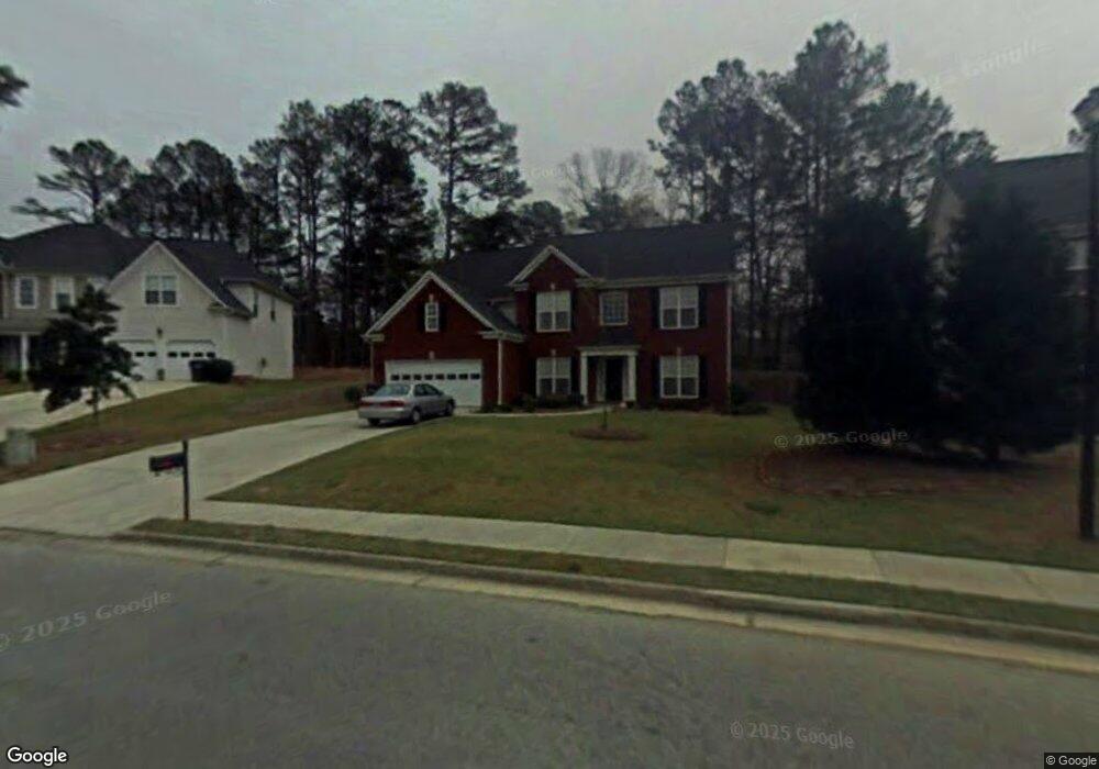
1980 Embassy Walk Ln Lilburn, GA 30047
Estimated Value: $466,788 - $533,000
4
Beds
3
Baths
3,109
Sq Ft
$162/Sq Ft
Est. Value
About This Home
This home is located at 1980 Embassy Walk Ln, Lilburn, GA 30047 and is currently estimated at $503,697, approximately $162 per square foot. 1980 Embassy Walk Ln is a home located in Gwinnett County with nearby schools including Head Elementary School, Five Forks Middle School, and Brookwood High School.
Ownership History
Date
Name
Owned For
Owner Type
Purchase Details
Closed on
Nov 25, 2000
Sold by
Parkland Homes Llc
Bought by
Dohani Mahmond K
Current Estimated Value
Home Financials for this Owner
Home Financials are based on the most recent Mortgage that was taken out on this home.
Original Mortgage
$222,300
Interest Rate
6.04%
Mortgage Type
New Conventional
Create a Home Valuation Report for This Property
The Home Valuation Report is an in-depth analysis detailing your home's value as well as a comparison with similar homes in the area
Home Values in the Area
Average Home Value in this Area
Purchase History
| Date | Buyer | Sale Price | Title Company |
|---|---|---|---|
| Dohani Mahmond K | $234,100 | -- |
Source: Public Records
Mortgage History
| Date | Status | Borrower | Loan Amount |
|---|---|---|---|
| Previous Owner | Dohani Mahmond K | $222,300 |
Source: Public Records
Tax History Compared to Growth
Tax History
| Year | Tax Paid | Tax Assessment Tax Assessment Total Assessment is a certain percentage of the fair market value that is determined by local assessors to be the total taxable value of land and additions on the property. | Land | Improvement |
|---|---|---|---|---|
| 2025 | $5,201 | $188,000 | $30,000 | $158,000 |
| 2024 | $4,840 | $198,080 | $30,000 | $168,080 |
| 2023 | $4,840 | $163,320 | $29,600 | $133,720 |
| 2022 | $4,804 | $163,320 | $29,600 | $133,720 |
| 2021 | $3,916 | $117,520 | $23,200 | $94,320 |
| 2020 | $3,943 | $117,520 | $23,200 | $94,320 |
| 2019 | $3,688 | $122,600 | $23,200 | $99,400 |
| 2018 | $3,688 | $110,840 | $17,200 | $93,640 |
| 2016 | $3,607 | $106,080 | $17,200 | $88,880 |
| 2015 | $3,251 | $88,240 | $14,800 | $73,440 |
| 2014 | -- | $88,240 | $14,800 | $73,440 |
Source: Public Records
Map
Nearby Homes
- 1905 Embassy Walk Ln
- 4000 Embassy Way
- 4353 Pond Edge Rd
- 2047 Cliffton Terrace
- 1547 Paxton Dr SW
- 1697 Paxton Dr SW
- 3728 Kelin Ct SW
- 3588 Kelin Ct SW
- 4268 Rocky Ledge Way
- 1776 Bear Cave SW
- 3594 Hedgestone Ln
- 3725 Hunting Ridge Dr SW
- 1725 Spindle Top Ct SW
- 1732 Beauregard Dr SW
- 3868 Buckland Dr SW
- 4107 Signal Ridge SW
- 1893 Hedgestone Ct
- 4171 Whispering Forest Ct SW
- 1970 Embassy Walk Ln
- 2000 Embassy Walk Ln
- 2008 McDaniels Bridge Rd SW
- 2018 McDaniels Bridge Rd SW
- 1960 Embassy Walk Ln
- 1965 Embassy Walk Ln
- 1995 Embassy Walk Ln
- 1950 Embassy Walk Ln
- 2005 Embassy Walk Ln
- 1997 Kensington High St SW
- 2007 Kensington High St SW
- 1945 Embassy Walk Ln
- 2028 McDaniels Bridge Rd SW
- 2019 McDaniels Bridge Rd SW
- 2017 Kensington High St SW
- 3930 Embassy Way
- 1940 Embassy Walk Ln
- 2029 McDaniels Bridge Rd SW
- 3910 Embassy Way
- 1977 Kensington High St SW