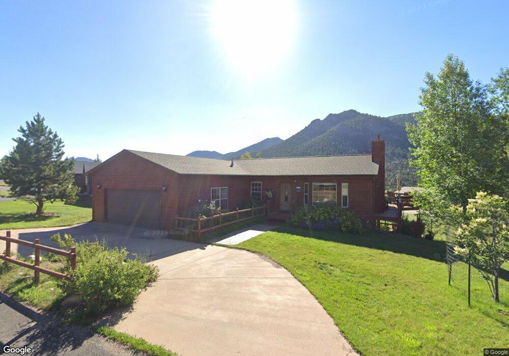
1980 Sharon Ct N Estes Park, CO 80517
Estimated Value: $696,222 - $975,000
4
Beds
3
Baths
2,920
Sq Ft
$293/Sq Ft
Est. Value
About This Home
This home is located at 1980 Sharon Ct N, Estes Park, CO 80517 and is currently estimated at $856,056, approximately $293 per square foot. 1980 Sharon Ct N is a home located in Larimer County with nearby schools including Estes Park K-5 School, Estes Park Options School, and Estes Park Middle School.
Ownership History
Date
Name
Owned For
Owner Type
Purchase Details
Closed on
Aug 12, 2021
Sold by
Tenzer Neil B and Tenzer Jan
Bought by
Tenzer Neil B and Tenzer Jan
Current Estimated Value
Purchase Details
Closed on
Oct 24, 2003
Sold by
Seybold Michael J and Konauka Seybold Audrey N
Bought by
Tenzer Neil B and Tenzer Jan
Home Financials for this Owner
Home Financials are based on the most recent Mortgage that was taken out on this home.
Original Mortgage
$258,800
Interest Rate
5.99%
Mortgage Type
Purchase Money Mortgage
Purchase Details
Closed on
Aug 31, 1999
Sold by
Ponche Charles L
Bought by
Seybold James S and Seybold Dianne D
Purchase Details
Closed on
Oct 1, 1994
Sold by
Docter James W
Bought by
Ponche Charles L
Purchase Details
Closed on
Jul 1, 1994
Sold by
Cenac Esther A
Bought by
Docter Eunice A
Create a Home Valuation Report for This Property
The Home Valuation Report is an in-depth analysis detailing your home's value as well as a comparison with similar homes in the area
Home Values in the Area
Average Home Value in this Area
Purchase History
| Date | Buyer | Sale Price | Title Company |
|---|---|---|---|
| Tenzer Neil B | -- | None Listed On Document | |
| Tenzer Neil B | $323,500 | -- | |
| Seybold James S | $74,500 | -- | |
| Ponche Charles L | $45,000 | -- | |
| Docter Eunice A | $35,000 | -- |
Source: Public Records
Mortgage History
| Date | Status | Borrower | Loan Amount |
|---|---|---|---|
| Previous Owner | Tenzer Neil B | $258,800 |
Source: Public Records
Tax History Compared to Growth
Tax History
| Year | Tax Paid | Tax Assessment Tax Assessment Total Assessment is a certain percentage of the fair market value that is determined by local assessors to be the total taxable value of land and additions on the property. | Land | Improvement |
|---|---|---|---|---|
| 2025 | $3,189 | $53,928 | $15,276 | $38,652 |
| 2024 | $3,135 | $53,928 | $15,276 | $38,652 |
| 2022 | $3,123 | $40,901 | $11,329 | $29,572 |
| 2021 | $3,207 | $42,078 | $11,655 | $30,423 |
| 2020 | $2,932 | $37,988 | $9,295 | $28,693 |
| 2019 | $2,916 | $37,988 | $9,295 | $28,693 |
| 2018 | $2,561 | $32,357 | $7,272 | $25,085 |
| 2017 | $2,575 | $32,357 | $7,272 | $25,085 |
| 2016 | $2,125 | $28,306 | $6,766 | $21,540 |
| 2015 | $2,147 | $28,310 | $6,770 | $21,540 |
| 2014 | $2,007 | $27,130 | $9,710 | $17,420 |
Source: Public Records
Map
Nearby Homes
- 2175 Carriage Dr
- 930 Highacres Dr
- 2319 Spruce Ave
- 2408 Longview Dr
- 0 Governors Ln Unit 1035838
- 407 Pawnee Dr
- 2441 Spruce Ave
- 1104 Willow Ct
- 2516 Pine Meadow Dr
- 1033 Tranquil Ln
- 619 Whispering Pines Dr
- 659 Peak View Dr
- 1341 Tall Pines Dr
- 384 Prospect Estates Ct
- 1692 Prospect Estates Dr
- 1062 Pine Knoll Dr
- 419 Whispering Pines Dr
- 2630 Ridge Ln
- 303 Curry Dr
- 1250 S Saint Vrain Ave Unit 11
- 1960 Sharon Ct N
- 1991 Sharon Ct N
- 1971 Sharon Ct N
- 2020 Sharon Ct S
- 1950 Sharon Ct N
- 2031 Monida Ct
- 1951 Sharon Ct N
- 980 Scott Ave
- 900 Scott Ave
- 1960 N Morris Ct
- 1940 Sharon Ct N
- 2030 Sharon Ct S
- 1980 N Morris Ct
- 1931 Sharon Ct N
- 1940 N Morris Ct
- 2041 Monida Ct
- 1981 Crags Ct
- 1930 Sharon Ct N
- 2050 S Sharon Ct
- 1020 Scott Ave