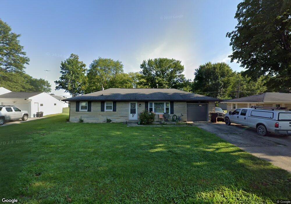
1982 W Northgate Dr Columbus, IN 47201
Estimated Value: $189,669 - $221,000
3
Beds
1
Bath
1,056
Sq Ft
$194/Sq Ft
Est. Value
About This Home
This home is located at 1982 W Northgate Dr, Columbus, IN 47201 and is currently estimated at $204,667, approximately $193 per square foot. 1982 W Northgate Dr is a home located in Bartholomew County with nearby schools including Taylorsville Elementary School, Northside Middle School, and Columbus North High School.
Ownership History
Date
Name
Owned For
Owner Type
Purchase Details
Closed on
Jul 15, 2010
Sold by
Ken Elkins
Bought by
Wehmiller Stacia M
Current Estimated Value
Purchase Details
Closed on
Jan 20, 2010
Sold by
Not Provided
Bought by
Not Provided
Purchase Details
Closed on
Aug 12, 2009
Sold by
Sheriff Of Bartholomew County
Bought by
Federal National Mortgage Association
Purchase Details
Closed on
Aug 11, 2006
Sold by
Leslie Debra S
Bought by
Arnold Deborah
Create a Home Valuation Report for This Property
The Home Valuation Report is an in-depth analysis detailing your home's value as well as a comparison with similar homes in the area
Home Values in the Area
Average Home Value in this Area
Purchase History
| Date | Buyer | Sale Price | Title Company |
|---|---|---|---|
| Wehmiller Stacia M | $83,000 | -- | |
| Wehmiller Stacia M | $83,000 | -- | |
| Not Provided | $83,000 | Statewide Title Co | |
| Federal National Mortgage Association | $78,681 | Attorney | |
| Arnold Deborah | -- | Attorney |
Source: Public Records
Mortgage History
| Date | Status | Borrower | Loan Amount |
|---|---|---|---|
| Closed | Federal National Mortgage Association | $0 |
Source: Public Records
Tax History
| Year | Tax Paid | Tax Assessment Tax Assessment Total Assessment is a certain percentage of the fair market value that is determined by local assessors to be the total taxable value of land and additions on the property. | Land | Improvement |
|---|---|---|---|---|
| 2025 | $832 | $135,200 | $27,700 | $107,500 |
| 2024 | $686 | $135,600 | $27,700 | $107,900 |
| 2023 | $686 | $121,700 | $27,700 | $94,000 |
| 2022 | $698 | $119,100 | $27,700 | $91,400 |
| 2021 | $600 | $108,400 | $14,600 | $93,800 |
| 2020 | $429 | $90,500 | $14,600 | $75,900 |
| 2019 | $381 | $90,500 | $14,600 | $75,900 |
| 2018 | $327 | $84,600 | $14,600 | $70,000 |
| 2017 | $307 | $82,400 | $13,600 | $68,800 |
| 2016 | $306 | $82,400 | $13,600 | $68,800 |
| 2014 | $352 | $86,200 | $13,600 | $72,600 |
Source: Public Records
Map
Nearby Homes
- 2015 Amur Ct
- 5961 N 200 W
- 2061 Beacon Ct
- 2034 Buckthorn Dr
- 2094 Buckthorn Dr
- 4993 Vance
- 8278 N Waterford Dr
- 4418 Ashworth Ln
- 4441 Sedgewick Ct
- 1963 Westminster Place
- 1908 Westminster Place
- 4148 Ashworth Ln
- 1010 Driftwood Ave
- 1641 W Paula Dr
- 1612 W Paula Dr
- 1652 W Paula Dr
- 1651 W Paula Dr
- 1611 W Paula Dr
- 1621 W Paula Dr
- 1642 W Paula Dr
- 1952 W Northgate Dr
- 2012 W Northgate Dr
- 1983 W Highland Ln
- 2042 W Northgate Dr
- 1953 W Highland Ln
- 2013 W Highland Ln
- 0 North St Unit 21334554
- 1932 W Northgate Dr
- 1981 W Northgate Dr
- 1951 W Northgate Dr
- 1933 W Highland Ln
- 2021 W Northgate Dr
- 2062 W Northgate Dr
- 1921 W Northgate Dr
- 2041 W Northgate Dr
- 2063 W Highland Ln
- 1901 W Northgate Dr
- 2072 W Northgate Dr
- 1984 W Highland Ln
Your Personal Tour Guide
Ask me questions while you tour the home.