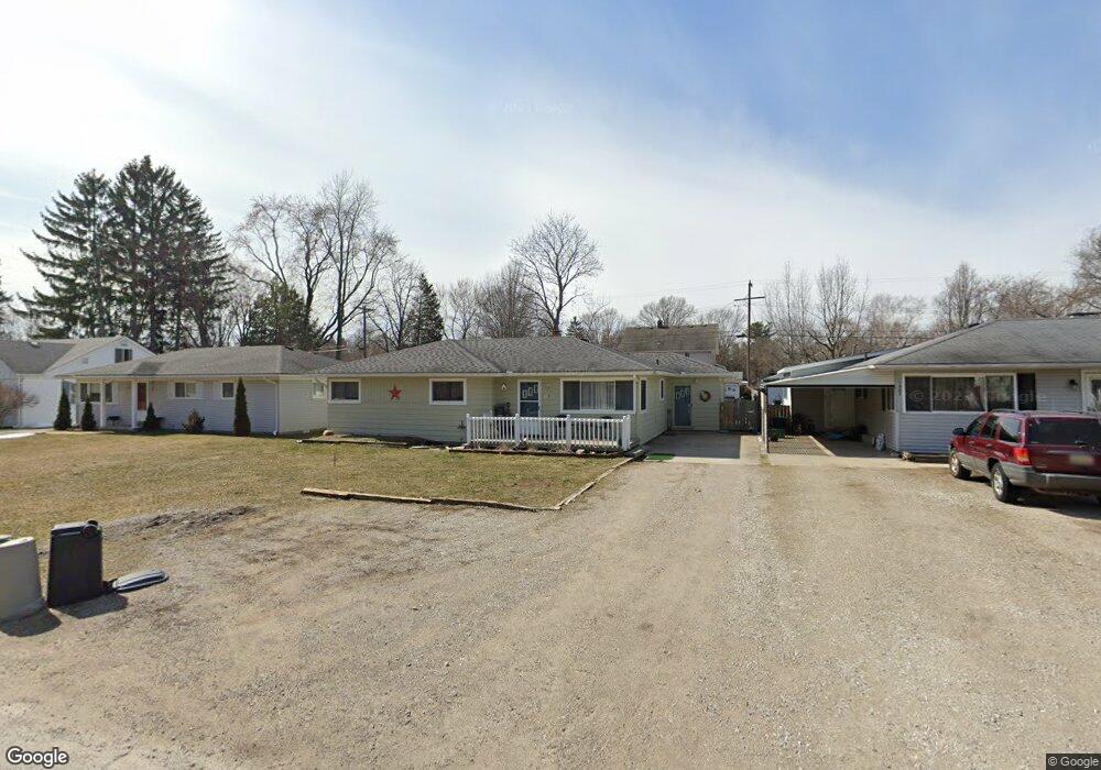
1985 Washington St Algonac, MI 48001
Estimated Value: $202,607 - $225,000
3
Beds
2
Baths
1,513
Sq Ft
$141/Sq Ft
Est. Value
About This Home
This home is located at 1985 Washington St, Algonac, MI 48001 and is currently estimated at $212,902, approximately $140 per square foot. 1985 Washington St is a home located in St. Clair County.
Ownership History
Date
Name
Owned For
Owner Type
Purchase Details
Closed on
Apr 14, 2025
Sold by
Knox Gregory W and Knox Cherie L
Bought by
Knox Gregory W and Knox Wesley Shannon
Current Estimated Value
Purchase Details
Closed on
Jan 18, 2023
Sold by
Knox Gregory W and Knox Cherie L
Bought by
Knox Cherie L and Knox Wesley Shannon
Purchase Details
Closed on
Aug 9, 2021
Sold by
K & O 1985 Washington Llc
Bought by
Knox Gregory and Knox Cherie
Purchase Details
Closed on
Oct 19, 2009
Sold by
Orsette Norman and Orsette Loretta
Bought by
K & O 1985 Washington Llc
Purchase Details
Closed on
Sep 18, 2009
Sold by
Secretary Of Housing & Urban Development
Bought by
Orsette Norman
Purchase Details
Closed on
Mar 19, 2009
Sold by
Citimortgage Inc
Bought by
The Secretary Of Housing & Urban Develop
Purchase Details
Closed on
Jul 17, 2008
Sold by
Aures Travis V and Aures Darlene M
Bought by
Abn Amro Mortgage Group Inc
Create a Home Valuation Report for This Property
The Home Valuation Report is an in-depth analysis detailing your home's value as well as a comparison with similar homes in the area
Home Values in the Area
Average Home Value in this Area
Purchase History
| Date | Buyer | Sale Price | Title Company |
|---|---|---|---|
| Knox Gregory W | -- | None Listed On Document | |
| Knox Gregory W | -- | None Listed On Document | |
| Knox Cherie L | -- | -- | |
| Knox Gregory | $70,000 | Ata National Title | |
| K & O 1985 Washington Llc | -- | None Available | |
| Orsette Norman | -- | None Available | |
| The Secretary Of Housing & Urban Develop | -- | None Available | |
| Abn Amro Mortgage Group Inc | $129,176 | None Available |
Source: Public Records
Tax History
| Year | Tax Paid | Tax Assessment Tax Assessment Total Assessment is a certain percentage of the fair market value that is determined by local assessors to be the total taxable value of land and additions on the property. | Land | Improvement |
|---|---|---|---|---|
| 2025 | $1,579 | $93,700 | $0 | $0 |
| 2024 | $3,402 | $89,000 | $0 | $0 |
| 2023 | $3,185 | $76,700 | $0 | $0 |
| 2022 | $3,919 | $67,700 | $0 | $0 |
| 2020 | $2,389 | $57,900 | $8,000 | $49,900 |
| 2019 | $2,337 | $56,600 | $0 | $0 |
| 2018 | $2,298 | $46,700 | $0 | $0 |
| 2017 | $2,202 | $45,800 | $0 | $0 |
| 2016 | $2,083 | $45,800 | $0 | $0 |
| 2015 | -- | $40,300 | $8,000 | $32,300 |
| 2014 | -- | $35,600 | $8,000 | $27,600 |
| 2013 | -- | $36,200 | $0 | $0 |
Source: Public Records
Map
Nearby Homes
- 474 South St
- 1719 Saint Clair River Dr
- 142 Channel Syde Dr
- 226 Roselawn St
- 130 Delta Dr
- 114 Interlochen Dr
- 00 Roselawn St
- 2037 W Park Dr
- 1523 Saint Clair River Dr
- 1516 Saint Clair River Dr
- 2567 St Clair River Dr
- 9287 N River Rd Unit 1
- 9287 N River Rd Unit 1 2 & 3
- 9287 N River Rd Unit 3
- 9287 N River Rd Unit 2
- 9188 Marsh Rd
- 9898 N River Rd
- 1103 Beth Ct
- 304 Kama Ct
- 9591 River Rd
- 1987 Washington St
- 1983 Washington St
- 1951 Washington St
- 1958 Saint Clair Blvd
- 2025 Washington St
- 1956 Saint Clair Blvd
- 1958 St Clair Blvd
- 1954 Saint Clair Blvd
- 1980 Washington St
- 1950 St Clair Blvd
- 1950 Saint Clair Blvd
- 2030 Saint Clair Blvd
- 1949 Washington St
- 2029 Washington St
- 2020 Washington St
- 490 Maple St
- 491 Sunset St
- 1948 Saint Clair Blvd
- 1947 Washington St Unit Bldg-Unit
- 1947 Washington St
Your Personal Tour Guide
Ask me questions while you tour the home.