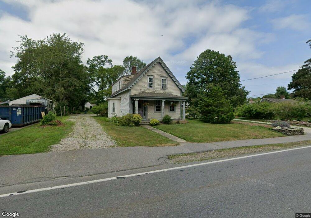
199 Main St Kingston, MA 02364
Estimated Value: $609,000 - $750,816
2
Beds
3
Baths
2,075
Sq Ft
$339/Sq Ft
Est. Value
About This Home
This home is located at 199 Main St, Kingston, MA 02364 and is currently estimated at $703,454, approximately $339 per square foot. 199 Main St is a home located in Plymouth County with nearby schools including Kingston Elementary School, Silver Lake Regional High School, and Kingston Intermediate School.
Ownership History
Date
Name
Owned For
Owner Type
Purchase Details
Closed on
Jul 31, 1998
Sold by
Johnson Doris M
Bought by
Heritage Jr David J and Heritage Shannon R
Current Estimated Value
Purchase Details
Closed on
Jun 13, 1995
Sold by
Leonardi Chester J Est
Bought by
Clarke Mark
Create a Home Valuation Report for This Property
The Home Valuation Report is an in-depth analysis detailing your home's value as well as a comparison with similar homes in the area
Home Values in the Area
Average Home Value in this Area
Purchase History
| Date | Buyer | Sale Price | Title Company |
|---|---|---|---|
| Heritage Jr David J | $148,000 | -- | |
| Clarke Mark | $104,000 | -- |
Source: Public Records
Mortgage History
| Date | Status | Borrower | Loan Amount |
|---|---|---|---|
| Open | Clarke Mark | $280,000 | |
| Closed | Clarke Mark | $300,000 | |
| Closed | Clarke Mark | $220,000 |
Source: Public Records
Tax History
| Year | Tax Paid | Tax Assessment Tax Assessment Total Assessment is a certain percentage of the fair market value that is determined by local assessors to be the total taxable value of land and additions on the property. | Land | Improvement |
|---|---|---|---|---|
| 2025 | $9,529 | $734,700 | $213,900 | $520,800 |
| 2024 | $8,798 | $692,200 | $213,900 | $478,300 |
| 2023 | $7,991 | $598,100 | $213,900 | $384,200 |
| 2022 | $8,012 | $549,500 | $189,600 | $359,900 |
| 2021 | $8,156 | $507,200 | $189,600 | $317,600 |
| 2020 | $8,257 | $507,200 | $189,600 | $317,600 |
| 2019 | $7,433 | $451,600 | $189,600 | $262,000 |
| 2018 | $6,921 | $420,700 | $189,600 | $231,100 |
| 2017 | $6,344 | $384,500 | $169,000 | $215,500 |
| 2016 | $6,299 | $357,700 | $159,700 | $198,000 |
| 2015 | $6,109 | $360,600 | $159,700 | $200,900 |
| 2014 | $5,926 | $355,300 | $154,400 | $200,900 |
Source: Public Records
Map
Nearby Homes
- Lot 17-1 Howland's Ln
- 1 Chestnut St
- 40 Landing Rd
- 278 Main St
- 149 Summer St
- 1 Watermans Ln
- 35 River St
- 16 Copper Beech Dr Marion Dr
- 100 Parks St Unit 32
- 735 Bay Rd
- 74 Tussock Brook Rd Unit 74
- 342 Country Club Way
- 13 Atwood St
- 24 Tremont St
- 94 Main St
- 40 Bay Farm Rd Unit 40
- 58 Bay Farm Rd
- 12 Curtis Ave
- 38 Cedar Ln
- Lot 17-3 Howlands Ln