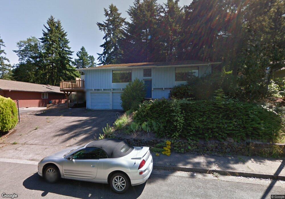
1990 Graham Dr Eugene, OR 97405
Crest Drive NeighborhoodEstimated Value: $565,000 - $669,000
3
Beds
3
Baths
2,828
Sq Ft
$218/Sq Ft
Est. Value
About This Home
This home is located at 1990 Graham Dr, Eugene, OR 97405 and is currently estimated at $617,472, approximately $218 per square foot. 1990 Graham Dr is a home located in Lane County with nearby schools including Adams Elementary School, Arts And Technology Academy At Jefferson, and Churchill High School.
Ownership History
Date
Name
Owned For
Owner Type
Purchase Details
Closed on
Oct 17, 2025
Sold by
Perez Trust and Perez Armando Duran
Bought by
Jefferson Main Llc
Current Estimated Value
Home Financials for this Owner
Home Financials are based on the most recent Mortgage that was taken out on this home.
Original Mortgage
$298,500
Outstanding Balance
$298,500
Interest Rate
6.5%
Mortgage Type
New Conventional
Estimated Equity
$318,972
Purchase Details
Closed on
Jul 3, 2022
Sold by
Perez Armando D
Bought by
Pcrez Trust
Purchase Details
Closed on
Dec 22, 2008
Sold by
Carr Sidney J and Carr Lynn
Bought by
Perez Armando D and Perez Leonor M
Home Financials for this Owner
Home Financials are based on the most recent Mortgage that was taken out on this home.
Original Mortgage
$157,500
Interest Rate
6.1%
Mortgage Type
Purchase Money Mortgage
Create a Home Valuation Report for This Property
The Home Valuation Report is an in-depth analysis detailing your home's value as well as a comparison with similar homes in the area
Home Values in the Area
Average Home Value in this Area
Purchase History
| Date | Buyer | Sale Price | Title Company |
|---|---|---|---|
| Jefferson Main Llc | -- | Lawyers Title | |
| Pcrez Trust | -- | None Listed On Document | |
| Perez Armando D | $210,000 | Fidelity National Title Insu |
Source: Public Records
Mortgage History
| Date | Status | Borrower | Loan Amount |
|---|---|---|---|
| Open | Jefferson Main Llc | $298,500 | |
| Previous Owner | Perez Armando D | $157,500 |
Source: Public Records
Tax History
| Year | Tax Paid | Tax Assessment Tax Assessment Total Assessment is a certain percentage of the fair market value that is determined by local assessors to be the total taxable value of land and additions on the property. | Land | Improvement |
|---|---|---|---|---|
| 2025 | $6,072 | $311,625 | -- | -- |
| 2024 | $5,996 | $302,549 | -- | -- |
| 2023 | $5,996 | $293,737 | -- | -- |
| 2022 | $5,617 | $285,182 | $0 | $0 |
| 2021 | $5,276 | $276,876 | $0 | $0 |
| 2020 | $5,295 | $268,812 | $0 | $0 |
| 2019 | $5,099 | $260,983 | $0 | $0 |
| 2018 | $4,741 | $246,002 | $0 | $0 |
| 2017 | $4,465 | $246,002 | $0 | $0 |
| 2016 | $4,328 | $238,837 | $0 | $0 |
| 2015 | $4,185 | $231,881 | $0 | $0 |
| 2014 | $4,076 | $225,127 | $0 | $0 |
Source: Public Records
Map
Nearby Homes
- 2850 Garfield St
- 1783 Graham Dr
- 3023 Ashley Loop
- 3093 Soloman Loop
- 0 Mclean Blvd Unit 24671448
- 0 Mclean Blvd Unit 697374759
- 2673 Garfield St
- 2225 W 28th Ave
- 2030 W 34th Ave
- 2037 Morning View Dr
- 2315 W 28th Ave
- 2323 W 28th Ave
- 2455 W 29th Ave
- 2572 W 28th Ave
- 2430 Wilson Dr
- 3087 Whitbeck Blvd
- 2490 Panorama Dr
- 2736 Kismet Way
- 2870 Hawkins Ln
- 2260 Orr Ln
- 1998 Graham Dr
- 1976 Graham Dr
- 2085 Mclean Blvd
- 2000 Graham Dr
- 2999 Garfield St
- 1970 Graham Dr
- 2055 Mclean Blvd
- 2091 Mclean Blvd
- 1965 Graham Dr
- 2020 Graham Dr
- 2990 Garfield St
- 2097 Mclean Blvd
- 2975 Garfield St
- 1960 Graham Dr
- 2100 Mclean Blvd
- 2080 Mclean Blvd
- 2030 Graham Dr
- 2960 Garfield St
- 1977 Graham Dr
Your Personal Tour Guide
Ask me questions while you tour the home.