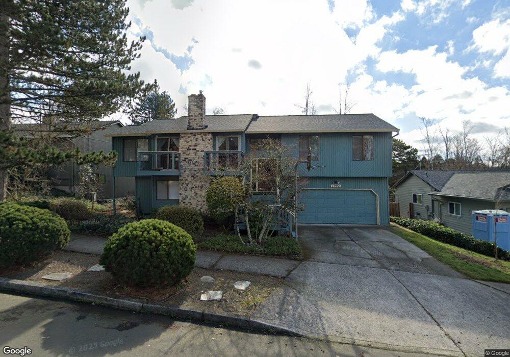
1992 SW 27th Dr Gresham, OR 97080
Southwest Gresham NeighborhoodEstimated Value: $519,000 - $572,000
3
Beds
3
Baths
1,534
Sq Ft
$356/Sq Ft
Est. Value
About This Home
This home is located at 1992 SW 27th Dr, Gresham, OR 97080 and is currently estimated at $545,667, approximately $355 per square foot. 1992 SW 27th Dr is a home located in Multnomah County with nearby schools including Dexter McCarty Middle School, Gresham High School, and Portland Adventist Elementary School.
Ownership History
Date
Name
Owned For
Owner Type
Purchase Details
Closed on
Sep 23, 1998
Sold by
Tinhof Bruce J and Tinhof Catherine C
Bought by
Bailey William S and Bailey Mary E
Current Estimated Value
Home Financials for this Owner
Home Financials are based on the most recent Mortgage that was taken out on this home.
Original Mortgage
$120,000
Interest Rate
6.78%
Mortgage Type
Purchase Money Mortgage
Create a Home Valuation Report for This Property
The Home Valuation Report is an in-depth analysis detailing your home's value as well as a comparison with similar homes in the area
Home Values in the Area
Average Home Value in this Area
Purchase History
| Date | Buyer | Sale Price | Title Company |
|---|---|---|---|
| Bailey William S | $180,642 | Chicago Title |
Source: Public Records
Mortgage History
| Date | Status | Borrower | Loan Amount |
|---|---|---|---|
| Previous Owner | Bailey William S | $120,000 |
Source: Public Records
Tax History
| Year | Tax Paid | Tax Assessment Tax Assessment Total Assessment is a certain percentage of the fair market value that is determined by local assessors to be the total taxable value of land and additions on the property. | Land | Improvement |
|---|---|---|---|---|
| 2025 | $6,897 | $338,920 | -- | -- |
| 2024 | $6,602 | $329,050 | -- | -- |
| 2023 | $6,015 | $319,470 | $0 | $0 |
| 2022 | $5,847 | $310,170 | $0 | $0 |
| 2021 | $5,700 | $301,140 | $0 | $0 |
| 2020 | $5,363 | $292,370 | $0 | $0 |
| 2019 | $5,222 | $283,860 | $0 | $0 |
| 2018 | $4,980 | $275,600 | $0 | $0 |
| 2017 | $4,778 | $267,580 | $0 | $0 |
| 2016 | $4,212 | $259,790 | $0 | $0 |
Source: Public Records
Map
Nearby Homes
- 2520 SW Towle Ave
- 3120 SW Orchard Place
- 1278 SW 27th Ct
- 1320 SW 31st St
- 1441 SW 23rd Ct
- 1261 SW Binford Lake Pkwy
- 1421 SW Binford Lake Pkwy
- 1859 SW Angeline Ave
- 3506 SW Battaglia Ave
- 3512 SW Battaglia Ave
- 3536 SW Battaglia Ave
- 3503 SW Battaglia Ave
- 3558 SW Battaglia Ave
- 3582 SW Battaglia Ave
- 1333 SW 19th Dr
- 1829 SW 17th St
- 3604 SW Battaglia Ave
- 3539 SW Battaglia Ave
- 3510 SW Binford Ave
- 3644 SW Battaglia Ave
- 1962 SW 27th Dr
- 2012 SW 27th Dr
- 2830 SW Riverview Ct
- 2042 SW 27th St
- 1995 SW 27th St
- 2860 SW Riverview Ct
- 2042 SW 27th Dr
- 1932 SW 27th Dr
- 1995 SW 27th Dr
- 2005 SW 27th Dr
- 2851 SW Willowbrook Ct
- 2837 SW Riverview Ct
- 1975 SW 27th Dr
- 2062 SW 27th Dr
- 1892 SW 27th Dr
- 2035 SW 27th Dr
- 2821 SW Willowbrook Ct
- 1915 SW 27th St
- 1945 SW 27th Dr
- 2890 SW Riverview Ct
Your Personal Tour Guide
Ask me questions while you tour the home.