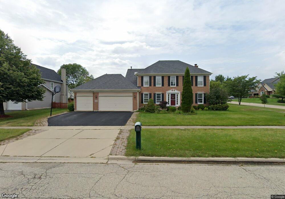
1996 Cheshire Dr Hoffman Estates, IL 60192
West Hoffman Estates NeighborhoodEstimated Value: $600,471 - $696,000
4
Beds
3
Baths
2,466
Sq Ft
$262/Sq Ft
Est. Value
About This Home
This home is located at 1996 Cheshire Dr, Hoffman Estates, IL 60192 and is currently estimated at $645,368, approximately $261 per square foot. 1996 Cheshire Dr is a home located in Cook County with nearby schools including Barbara B. Rose Elementary School, Barrington Mdle School- Prairie Cmps, and Barrington High School.
Ownership History
Date
Name
Owned For
Owner Type
Purchase Details
Closed on
Aug 30, 1996
Sold by
Deer Crossing Ii Ltd Partnership
Bought by
Castro Andres R and Castro Violeta A
Current Estimated Value
Home Financials for this Owner
Home Financials are based on the most recent Mortgage that was taken out on this home.
Original Mortgage
$207,000
Outstanding Balance
$12,086
Interest Rate
8.27%
Estimated Equity
$633,282
Create a Home Valuation Report for This Property
The Home Valuation Report is an in-depth analysis detailing your home's value as well as a comparison with similar homes in the area
Home Values in the Area
Average Home Value in this Area
Purchase History
| Date | Buyer | Sale Price | Title Company |
|---|---|---|---|
| Castro Andres R | $302,000 | 1St American Title |
Source: Public Records
Mortgage History
| Date | Status | Borrower | Loan Amount |
|---|---|---|---|
| Open | Castro Andres R | $207,000 |
Source: Public Records
Tax History
| Year | Tax Paid | Tax Assessment Tax Assessment Total Assessment is a certain percentage of the fair market value that is determined by local assessors to be the total taxable value of land and additions on the property. | Land | Improvement |
|---|---|---|---|---|
| 2025 | $10,236 | $57,000 | $9,315 | $47,685 |
| 2024 | $10,236 | $43,263 | $8,073 | $35,190 |
| 2023 | $9,905 | $46,000 | $8,073 | $37,927 |
| 2022 | $9,905 | $46,000 | $8,073 | $37,927 |
| 2021 | $7,604 | $32,729 | $7,452 | $25,277 |
| 2020 | $8,243 | $35,405 | $7,452 | $27,953 |
| 2019 | $8,089 | $39,339 | $7,452 | $31,887 |
| 2018 | $6,502 | $31,470 | $6,520 | $24,950 |
| 2017 | $6,945 | $31,470 | $6,520 | $24,950 |
| 2016 | $7,552 | $35,024 | $6,520 | $28,504 |
| 2015 | $6,534 | $28,852 | $5,899 | $22,953 |
| 2014 | $6,475 | $28,852 | $5,899 | $22,953 |
| 2013 | $6,907 | $32,009 | $5,899 | $26,110 |
Source: Public Records
Map
Nearby Homes
- 1940 Morningview Dr
- 5285 Shotkoski Dr
- 2045 Morningview Dr
- 5355 Galloway Dr
- 2140 Colchester Ave
- 1405 Mallard Ln
- 5670 Brentwood Dr Unit 5
- 1294 Hunters Ridge E
- 2221 Edgartown Ln
- 1385 Caribou Ln Unit 4
- 1632 Acorn Dr
- 5761 Providence Dr Unit 4
- 1870 Hampshire Dr
- 1812 Kelberg Ave Unit 482
- 11N575 Rohrssen Rd
- 1590 Russell Dr
- 6085 Irene Dr
- 6131 Canterbury Ln Unit 281
- 12N100 Berner Dr
- 1190 Alpine Ln
- 5225 Birch Bark Dr
- 1986 Cheshire Dr
- 2016 Cheshire Dr
- 5230 Sawhorse Dr
- 1999 Cheshire Dr
- 1989 Cheshire Dr
- 5235 Birch Bark Dr
- 5220 Birch Bark Dr
- 1979 Cheshire Dr
- 2009 Cheshire Dr
- 2026 Cheshire Dr
- 5230 Birch Bark Dr
- 1966 Cheshire Dr
- 5240 Sawhorse Dr
- 5245 Birch Bark Dr
- 2019 Cheshire Dr
- 1969 Cheshire Dr
- 5240 Birch Bark Dr
- 5245 Sawhorse Dr
- 2036 Cheshire Dr
Your Personal Tour Guide
Ask me questions while you tour the home.