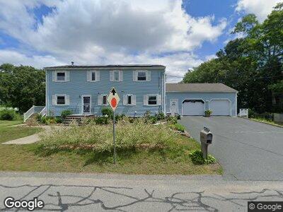
1996 Shawmut Ave North Dartmouth, MA 02747
Estimated Value: $570,725 - $787,000
3
Beds
2
Baths
2,444
Sq Ft
$278/Sq Ft
Est. Value
About This Home
This home is located at 1996 Shawmut Ave, North Dartmouth, MA 02747 and is currently estimated at $680,181, approximately $278 per square foot. 1996 Shawmut Ave is a home located in Bristol County with nearby schools including Elwyn G. Campbell Elementary school, Normandin Middle School, and New Bedford High School.
Ownership History
Date
Name
Owned For
Owner Type
Purchase Details
Closed on
Oct 28, 2022
Sold by
Amaral Julirtta
Bought by
Julirtta Amaral Irt
Current Estimated Value
Purchase Details
Closed on
Feb 24, 1993
Sold by
Kummer Karl A and Kummer Janice
Bought by
Amaral Manuel and Amaral Juliet
Home Financials for this Owner
Home Financials are based on the most recent Mortgage that was taken out on this home.
Original Mortgage
$125,000
Interest Rate
8.03%
Mortgage Type
Purchase Money Mortgage
Create a Home Valuation Report for This Property
The Home Valuation Report is an in-depth analysis detailing your home's value as well as a comparison with similar homes in the area
Home Values in the Area
Average Home Value in this Area
Purchase History
| Date | Buyer | Sale Price | Title Company |
|---|---|---|---|
| Julirtta Amaral Irt | -- | None Available | |
| Amaral Manuel | $165,000 | -- |
Source: Public Records
Mortgage History
| Date | Status | Borrower | Loan Amount |
|---|---|---|---|
| Previous Owner | Kummer Karl A | $30,000 | |
| Previous Owner | Kummer Karl A | $125,000 | |
| Previous Owner | Kummer Karl A | $127,500 | |
| Previous Owner | Kummer Karl A | $110,000 |
Source: Public Records
Tax History Compared to Growth
Tax History
| Year | Tax Paid | Tax Assessment Tax Assessment Total Assessment is a certain percentage of the fair market value that is determined by local assessors to be the total taxable value of land and additions on the property. | Land | Improvement |
|---|---|---|---|---|
| 2024 | $5,827 | $485,600 | $156,200 | $329,400 |
| 2023 | $5,137 | $359,500 | $106,600 | $252,900 |
| 2022 | $4,848 | $312,000 | $97,400 | $214,600 |
| 2021 | $4,864 | $312,000 | $97,400 | $214,600 |
| 2020 | $4,905 | $303,500 | $99,900 | $203,600 |
| 2019 | $4,999 | $303,500 | $99,900 | $203,600 |
| 2018 | $5,252 | $315,800 | $102,500 | $213,300 |
| 2017 | $5,122 | $306,900 | $102,500 | $204,400 |
| 2016 | $4,865 | $295,000 | $102,500 | $192,500 |
| 2015 | $4,398 | $279,600 | $102,500 | $177,100 |
| 2014 | $4,304 | $283,900 | $107,600 | $176,300 |
Source: Public Records
Map
Nearby Homes
- 1936 Shawmut Ave
- 135 High Hill Rd
- 636 Fauce Corner Rd
- Lot 582 Aviation Way
- 269 Flag Swamp Rd
- 785 Tarkiln Hill Rd
- 491 Faunce Corner Rd
- 0 Hammond St
- WS Worthington St
- 411 Faunce Corner Rd
- 335 Old Fall River Rd
- 239 Worcester St
- 112 Worcester St
- 300 Jarry St
- 0 Hathaway Rd
- 14 Maywood St
- 274 Irvington St
- 1143 Tacoma St
- 60 Avery St
- 257 Appleton St
- 1996 Shawmut Ave
- 1984 Shawmut Ave
- 708 New Plainville Rd
- 1993 Shawmut Ave
- 1999 Shawmut Ave
- 1469 Old Plainville Rd
- 1451 Old Plainville Rd
- 715 New Plainville Rd
- 1485 Old Plainville Rd
- 1443 Old Plainville Rd
- 762 New Plainville Rd
- 1487 Old Plainville Rd Unit 1489
- 692 New Plainville Rd
- 1437 Old Plainville Rd
- 1476 Old Plainville Rd
- 1493 Old Plainville Rd Unit 1495
- 766 New Plainville Rd Unit 768
- 1484 Old Plainville Rd
- 1450 Old Plainville Rd
- 1431 Old Plainville Rd