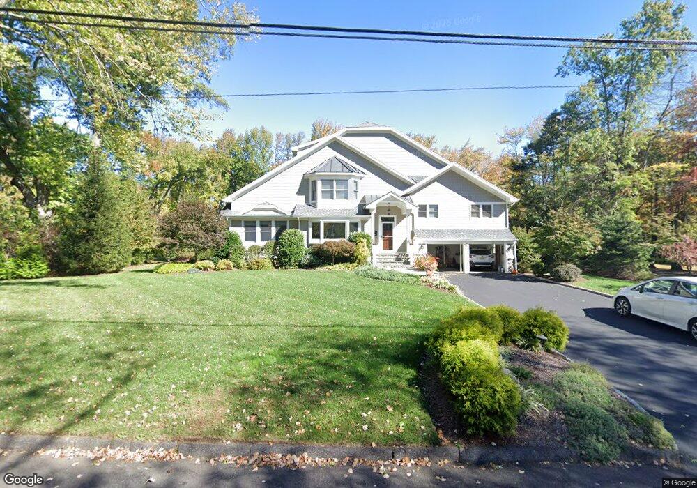
1997 Duncan Dr Scotch Plains, NJ 07076
Estimated Value: $905,199 - $1,352,000
--
Bed
--
Bath
3,124
Sq Ft
$364/Sq Ft
Est. Value
About This Home
This home is located at 1997 Duncan Dr, Scotch Plains, NJ 07076 and is currently estimated at $1,138,050, approximately $364 per square foot. 1997 Duncan Dr is a home located in Union County with nearby schools including William J. McGinn Elementary School, Terrill Middle School, and Scotch Plains-Fanwood High School.
Ownership History
Date
Name
Owned For
Owner Type
Purchase Details
Closed on
Jun 30, 1999
Sold by
Forster Erna
Bought by
Strauss Jeffrey E and Strauss Angelique P
Current Estimated Value
Home Financials for this Owner
Home Financials are based on the most recent Mortgage that was taken out on this home.
Original Mortgage
$284,000
Outstanding Balance
$77,228
Interest Rate
7.19%
Estimated Equity
$1,060,822
Create a Home Valuation Report for This Property
The Home Valuation Report is an in-depth analysis detailing your home's value as well as a comparison with similar homes in the area
Home Values in the Area
Average Home Value in this Area
Purchase History
| Date | Buyer | Sale Price | Title Company |
|---|---|---|---|
| Strauss Jeffrey E | $355,000 | -- |
Source: Public Records
Mortgage History
| Date | Status | Borrower | Loan Amount |
|---|---|---|---|
| Open | Strauss Jeffrey E | $284,000 |
Source: Public Records
Tax History Compared to Growth
Tax History
| Year | Tax Paid | Tax Assessment Tax Assessment Total Assessment is a certain percentage of the fair market value that is determined by local assessors to be the total taxable value of land and additions on the property. | Land | Improvement |
|---|---|---|---|---|
| 2025 | $21,335 | $181,300 | $51,300 | $130,000 |
| 2024 | $20,706 | $181,300 | $51,300 | $130,000 |
| 2023 | $20,706 | $181,300 | $51,300 | $130,000 |
| 2022 | $20,460 | $181,300 | $51,300 | $130,000 |
| 2021 | $20,425 | $181,300 | $51,300 | $130,000 |
| 2020 | $20,327 | $181,300 | $51,300 | $130,000 |
| 2019 | $16,449 | $147,800 | $51,300 | $96,500 |
| 2018 | $16,172 | $147,800 | $51,300 | $96,500 |
| 2017 | $15,813 | $147,800 | $51,300 | $96,500 |
| 2016 | $15,509 | $147,800 | $51,300 | $96,500 |
| 2015 | $15,254 | $147,800 | $51,300 | $96,500 |
| 2014 | $14,752 | $147,800 | $51,300 | $96,500 |
Source: Public Records
Map
Nearby Homes
- 2 Brookside Ct
- 1466 Lamberts Mill Rd
- 314 Highgate Ave
- 2154 W Broad St
- 119 Lamberts Mill Rd
- 1972 W Broad St
- 2 Dutch Ln
- 57 Rambling Dr
- 1933 Mary Ellen Ln
- 2116 Newark Ave
- 525 Edgar Rd
- 2 Unami Ln
- 608 Hort St
- 676 Vermont St
- 1840 Raritan Rd
- 1840 Lake Ave
- 1148 Tanglewood Ln
- 187 King St
- 1701 Raritan Rd
- 1380 Terrill Rd