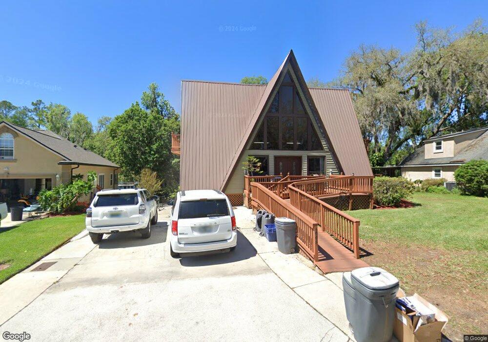
1998 Cornell Rd Middleburg, FL 32068
Estimated Value: $251,300 - $318,000
3
Beds
1
Bath
1,234
Sq Ft
$229/Sq Ft
Est. Value
About This Home
This home is located at 1998 Cornell Rd, Middleburg, FL 32068 and is currently estimated at $282,075, approximately $228 per square foot. 1998 Cornell Rd is a home located in Clay County with nearby schools including Middleburg Elementary School, Middleburg High School, and Lake Asbury Junior High School.
Ownership History
Date
Name
Owned For
Owner Type
Purchase Details
Closed on
Dec 8, 2015
Sold by
Burgart John J and Burgart Victoria A
Bought by
John J Burgart Trust and Goddard Sandra Burgart
Current Estimated Value
Purchase Details
Closed on
Dec 11, 2000
Sold by
Mckay Morgan Ellen and Mckay Steven T
Bought by
Burgart John J and Burgart Victoria A
Home Financials for this Owner
Home Financials are based on the most recent Mortgage that was taken out on this home.
Original Mortgage
$104,000
Interest Rate
7.79%
Create a Home Valuation Report for This Property
The Home Valuation Report is an in-depth analysis detailing your home's value as well as a comparison with similar homes in the area
Home Values in the Area
Average Home Value in this Area
Purchase History
| Date | Buyer | Sale Price | Title Company |
|---|---|---|---|
| John J Burgart Trust | -- | Attorney | |
| Burgart John J | $130,000 | -- |
Source: Public Records
Mortgage History
| Date | Status | Borrower | Loan Amount |
|---|---|---|---|
| Closed | Burgart John J | $104,000 |
Source: Public Records
Tax History Compared to Growth
Tax History
| Year | Tax Paid | Tax Assessment Tax Assessment Total Assessment is a certain percentage of the fair market value that is determined by local assessors to be the total taxable value of land and additions on the property. | Land | Improvement |
|---|---|---|---|---|
| 2024 | $1,640 | $129,938 | -- | -- |
| 2023 | $1,640 | $126,154 | $0 | $0 |
| 2022 | $1,474 | $122,480 | $0 | $0 |
| 2021 | $1,467 | $118,913 | $0 | $0 |
| 2020 | $1,422 | $117,272 | $0 | $0 |
| 2019 | $1,397 | $114,636 | $0 | $0 |
| 2018 | $1,274 | $112,499 | $0 | $0 |
| 2017 | $1,264 | $110,185 | $0 | $0 |
| 2016 | $1,258 | $107,919 | $0 | $0 |
| 2015 | $1,297 | $107,169 | $0 | $0 |
| 2014 | $1,264 | $106,319 | $0 | $0 |
Source: Public Records
Map
Nearby Homes
- 128 Lee Dr S
- 2064 Cornell Rd
- 2057 Cornell Rd
- 2087 Harvard St
- 0 Main St Unit 2099304
- 3716 Main St
- 0 Blanding Blvd Unit 2103998
- 2498 Jennings Farm Dr
- 2326 North St
- 2264 Brannings Sawmill Ct
- 2487 Jennings Farm Dr
- 2242 Brannings Sawmill Ct
- 2481 Jennings Farm Dr
- 2265 Brannings Sawmill Ct
- 2466 Jennings Farm Dr
- 2220 Palisade Point
- 2105 Windward Cay Ln
- 2460 Jennings Farm Dr
- 2121 Windward Cay Ln
- 2125 Windward Cay Ln
- 1994 Cornell Rd
- 2000 Cornell Rd
- 1992 Cornell Rd
- 2002 Cornell Rd
- 1999 Cornell Rd
- 1991 Cornell Rd
- 2006 Cornell Rd
- 2010 Cornell Rd
- 2003 Cornell Rd
- 1990 Cornell Rd
- 1985 Cornell Rd
- 2007 Cornell Rd
- 2008 Cornell Rd
- 1981 Cornell Rd
- 2011 Cornell Rd
- 2012 Cornell Rd
- 1982 Cornell Rd
- 138 S Lee Dr
- 1977 Cornell Rd
- 2014 Cornell Rd