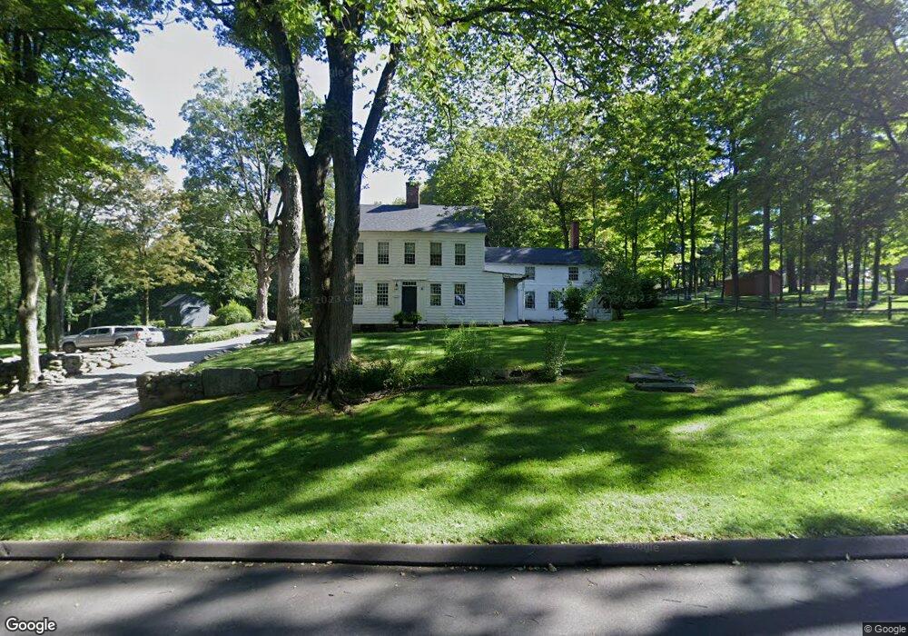
2 Blackman Rd Newtown, CT 06470
Estimated Value: $735,000 - $1,087,000
4
Beds
5
Baths
3,778
Sq Ft
$239/Sq Ft
Est. Value
About This Home
This home is located at 2 Blackman Rd, Newtown, CT 06470 and is currently estimated at $901,372, approximately $238 per square foot. 2 Blackman Rd is a home located in Fairfield County with nearby schools including Reed Intermediate School, Head O'Meadow Elementary School, and Newtown Middle School.
Ownership History
Date
Name
Owned For
Owner Type
Purchase Details
Closed on
Jun 1, 2009
Sold by
Wenblad Dorothy E
Bought by
Zahansky Jeffrey A and Zahansky Bonnie M
Current Estimated Value
Home Financials for this Owner
Home Financials are based on the most recent Mortgage that was taken out on this home.
Original Mortgage
$275,500
Interest Rate
4.87%
Create a Home Valuation Report for This Property
The Home Valuation Report is an in-depth analysis detailing your home's value as well as a comparison with similar homes in the area
Home Values in the Area
Average Home Value in this Area
Purchase History
| Date | Buyer | Sale Price | Title Company |
|---|---|---|---|
| Zahansky Jeffrey A | $290,000 | -- | |
| Zahansky Jeffrey A | $290,000 | -- |
Source: Public Records
Mortgage History
| Date | Status | Borrower | Loan Amount |
|---|---|---|---|
| Open | Zahansky Jeffrey A | $420,000 | |
| Closed | Zahansky Jeffrey A | $400,000 | |
| Closed | Zahansky Jeffrey A | $275,500 |
Source: Public Records
Tax History
| Year | Tax Paid | Tax Assessment Tax Assessment Total Assessment is a certain percentage of the fair market value that is determined by local assessors to be the total taxable value of land and additions on the property. | Land | Improvement |
|---|---|---|---|---|
| 2025 | $11,050 | $384,490 | $104,650 | $279,840 |
| 2024 | $10,370 | $384,490 | $104,650 | $279,840 |
| 2023 | $9,924 | $378,200 | $104,650 | $273,550 |
| 2022 | $8,935 | $257,710 | $88,170 | $169,540 |
| 2021 | $20,777 | $258,300 | $88,170 | $170,130 |
| 2020 | $8,979 | $258,300 | $88,170 | $170,130 |
| 2019 | $8,981 | $258,300 | $88,170 | $170,130 |
| 2018 | $8,844 | $258,300 | $88,170 | $170,130 |
| 2017 | $8,979 | $265,100 | $92,400 | $172,700 |
| 2016 | $8,907 | $265,100 | $92,400 | $172,700 |
| 2015 | $8,767 | $265,100 | $92,400 | $172,700 |
| 2014 | $8,830 | $265,100 | $92,400 | $172,700 |
Source: Public Records
Map
Nearby Homes
- 40 Mount Pleasant Rd
- 4 Twist Hill Rd
- 81 Currituck Rd
- 6 Westwood Terrace
- 23 Taunton Ln
- 25 Taunton Ln
- 55 Sugar St Unit 17A
- 55 Sugar St Unit 9
- 55 Sugar St Unit 6
- 55 Sugar St Unit 2
- 55 Sugar St Unit 31
- 55 Sugar St Unit 33
- 55 Sugar St Unit 3
- 55 Sugar St Unit 20
- 55 Sugar St Unit 28
- 55 Sugar St Unit 14
- 55 Sugar St Unit 12
- 55 Sugar St Unit 27
- 55 Sugar St Unit 5
- 55 Sugar St Unit 10
- 58 Mount Pleasant Rd
- 1 Blackman Rd
- 56 Mount Pleasant Rd
- 23 Diamond Dr
- 54A Mount Pleasant Rd
- 54 Mount Pleasant Rd
- 28 Diamond Dr
- 21 Diamond Dr
- 1 Whitewood Rd
- 26 Diamond Dr
- 57 Mount Pleasant Rd
- 49 Mount Pleasant Rd
- 50 Mount Pleasant Rd
- 8 Middleton Rd
- 24 Diamond Dr
- 17 Diamond Dr
- 48 Mount Pleasant Rd
- 22 Diamond Dr
- 15 Diamond Dr
- 46 Mount Pleasant Rd
Your Personal Tour Guide
Ask me questions while you tour the home.