Estimated Value: $1,333,000 - $1,795,000
4
Beds
4
Baths
4,672
Sq Ft
$321/Sq Ft
Est. Value
About This Home
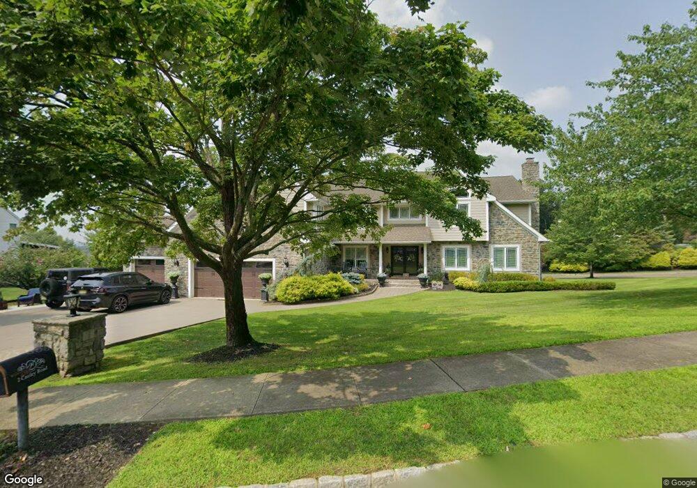
This home is located at 2 Cauley Rd, Wayne, NJ 07470 and is currently estimated at $1,501,132, approximately $321 per square foot. 2 Cauley Rd is a home located in Passaic County with nearby schools including Albert P. Terhune Elementary School, Schuyler-Colfax Middle School, and Wayne Hills High School.
Ownership History
Date
Name
Owned For
Owner Type
Purchase Details
Closed on
Jul 15, 2008
Sold by
Boscarino Emanuel and Boscarino Maria A
Bought by
Hatzigianakis Nikolaos and Hatzigianakis Andromahi
Current Estimated Value
Home Financials for this Owner
Home Financials are based on the most recent Mortgage that was taken out on this home.
Original Mortgage
$300,000
Outstanding Balance
$196,268
Interest Rate
6.35%
Mortgage Type
New Conventional
Estimated Equity
$1,304,864
Create a Home Valuation Report for This Property
The Home Valuation Report is an in-depth analysis detailing your home's value as well as a comparison with similar homes in the area
Home Values in the Area
Average Home Value in this Area
Purchase History
| Date | Buyer | Sale Price | Title Company |
|---|---|---|---|
| Hatzigianakis Nikolaos | $857,000 | -- |
Source: Public Records
Mortgage History
| Date | Status | Borrower | Loan Amount |
|---|---|---|---|
| Open | Hatzigianakis Nikolaos | $300,000 |
Source: Public Records
Tax History
| Year | Tax Paid | Tax Assessment Tax Assessment Total Assessment is a certain percentage of the fair market value that is determined by local assessors to be the total taxable value of land and additions on the property. | Land | Improvement |
|---|---|---|---|---|
| 2025 | $25,449 | $428,000 | $188,600 | $239,400 |
| 2024 | $24,473 | $428,000 | $188,600 | $239,400 |
Source: Public Records
Map
Nearby Homes
- 92 Old Homestead Rd
- 24 Peterson Rd
- 27 Grandview Dr
- 138 Levinberg Ln
- 1360 Hamburg Turnpike Unit 104
- 139 Webster Dr
- 1316 Alps Rd
- 5 Bourbon St
- 511 Brittany Dr
- 37 Atwood Place
- 703 Brittany Dr
- 648 Black Oak Ridge Rd
- 2 Eden Place
- 1656 Hamburg Turnpike
- 36 Yellow Brick Rd
- 8605 Brittany Dr
- 1666 Hamburg Turnpike
- 174 Hillcrest Dr
- 8717 Brittany Dr
- 8015 Brittany Dr
- 4 Cauley Rd
- 3 Cauley Rd
- 1 Cobble Stone Ct
- 4 Cobble Stone Ct
- 6 Cobble Stone Ct
- 5 Cauley Rd
- 2 Cobble Stone Ct
- 28 Peterson Rd
- 10 Stone Hill Rd
- 8 Stone Hill Rd
- 3 Stone Hill Rd
- 12 Stone Hill Rd
- 6 Stone Hill Rd
- 68 Old Homestead Rd
- 38 Peterson Rd
- 72 Old Homestead Rd
- 62 Old Homestead Rd
- 0 Peterson Rd
- 1 Stone Hill Rd
- 14 Stone Hill Rd
Your Personal Tour Guide
Ask me questions while you tour the home.