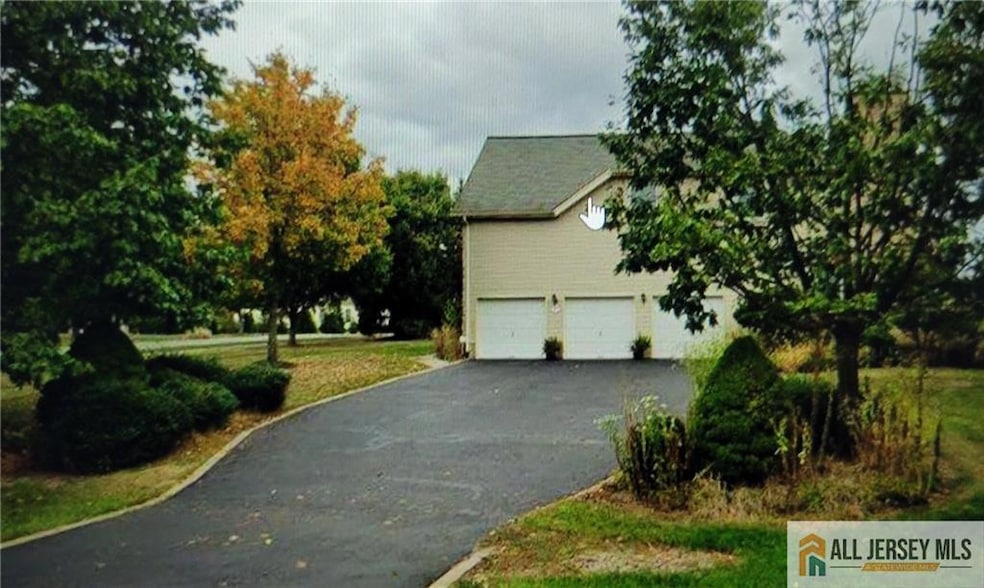
2 Colonial Ct Plainsboro, NJ 08536
Estimated payment $8,689/month
Highlights
- Sitting Area In Primary Bedroom
- Contemporary Architecture
- Corner Lot
- Town Center Elementary School Rated A
- Wood Flooring
- Great Room
About This Home
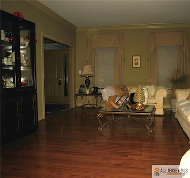
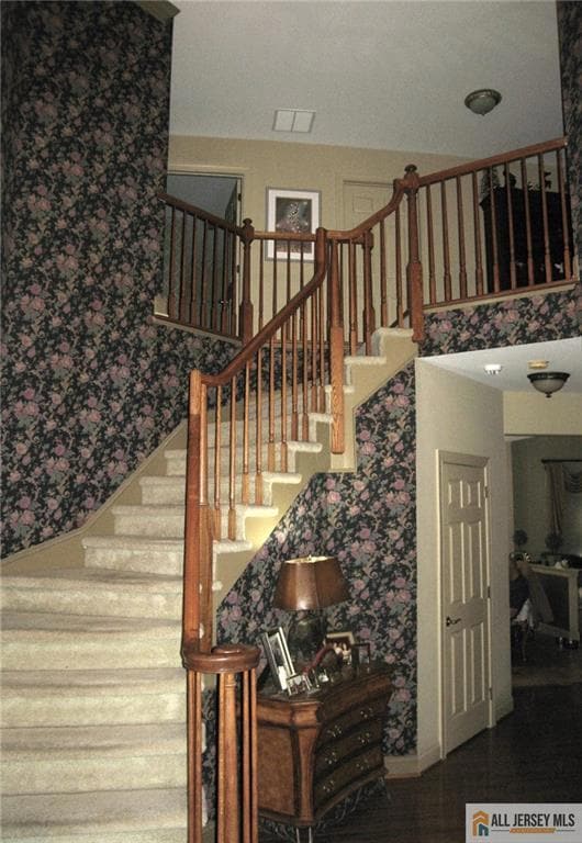
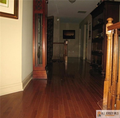
Welcome to this spacious 4 Bedroom 2.5 Bath Augusta Model with dramatic 2 story entry foyer located in the desired Grover Mills Development. Open concept leads to two story great room with rear staircase. Poured concrete full basement with 3 car side entry garage. Master bedroom with three walk-in closets, sitting room and full bathroom with shower and sunken tub. Recessed lighting throughout. Hardwood flooring on first level and upstairs hallway. The master bedroom suite with an updated en suite bathroom three walk in closets and sitting room. This house is a corner unit with central vac and sprinkler system and attic fan. Roof replaced 5 years ago. Located in the neighborhood adjacent to West Windsor Plainsboro High School North and its sprawling 80-acre campus, across the street from Community Middle School. Enjoy proximity to Plainsboro Town Center, Princeton Junction Train Station and downtown Princeton. House needs TLC. Not to be missed.
Home Details
Home Type
- Single Family
Est. Annual Taxes
- $22,454
Year Built
- Built in 2000
Lot Details
- 0.8 Acre Lot
- Corner Lot
- Property is zoned R100
Parking
- 3 Car Attached Garage
- Driveway
- On-Street Parking
- Open Parking
Home Design
- Contemporary Architecture
- Asphalt Roof
Interior Spaces
- 3,485 Sq Ft Home
- 2-Story Property
- Central Vacuum
- Recessed Lighting
- Wood Burning Fireplace
- Entrance Foyer
- Great Room
- Living Room
- Formal Dining Room
- Den
- Library
- Utility Room
- Basement Fills Entire Space Under The House
Kitchen
- Eat-In Kitchen
- Gas Oven or Range
- Dishwasher
- Kitchen Island
- Granite Countertops
Flooring
- Wood
- Carpet
- Ceramic Tile
Bedrooms and Bathrooms
- 4 Bedrooms
- Sitting Area In Primary Bedroom
- Walk-In Closet
- Primary Bathroom is a Full Bathroom
- Dual Sinks
- Separate Shower in Primary Bathroom
Laundry
- Dryer
- Washer
Location
- Property is near shops
Utilities
- Forced Air Heating and Cooling System
- Underground Utilities
- Gas Water Heater
Community Details
- Association fees include common area maintenance, trash
- Estates/Grovers Mill Sec Subdivision
Map
Home Values in the Area
Average Home Value in this Area
Tax History
| Year | Tax Paid | Tax Assessment Tax Assessment Total Assessment is a certain percentage of the fair market value that is determined by local assessors to be the total taxable value of land and additions on the property. | Land | Improvement |
|---|---|---|---|---|
| 2025 | $22,454 | $859,300 | $293,500 | $565,800 |
| 2024 | $21,912 | $859,300 | $293,500 | $565,800 |
| 2023 | $21,912 | $859,300 | $293,500 | $565,800 |
| 2022 | $21,577 | $859,300 | $293,500 | $565,800 |
| 2021 | $20,099 | $859,300 | $293,500 | $565,800 |
| 2020 | $20,554 | $859,300 | $293,500 | $565,800 |
| 2019 | $20,099 | $859,300 | $293,500 | $565,800 |
| 2018 | $19,652 | $859,300 | $293,500 | $565,800 |
| 2017 | $20,645 | $929,100 | $293,500 | $635,600 |
| 2016 | $19,734 | $929,100 | $293,500 | $635,600 |
| 2015 | $20,134 | $797,700 | $265,100 | $532,600 |
| 2014 | $19,935 | $797,700 | $265,100 | $532,600 |
Property History
| Date | Event | Price | List to Sale | Price per Sq Ft |
|---|---|---|---|---|
| 11/30/2025 11/30/25 | For Sale | $1,300,000 | -- | $373 / Sq Ft |
Purchase History
| Date | Type | Sale Price | Title Company |
|---|---|---|---|
| Deed | $629,000 | -- | |
| Deed | $472,415 | -- |
Mortgage History
| Date | Status | Loan Amount | Loan Type |
|---|---|---|---|
| Open | $503,200 | No Value Available | |
| Previous Owner | $320,000 | No Value Available |
Source: All Jersey MLS
MLS Number: 2660901M
APN: 18-01902-0000-00065
Disclaimer: Certain information contained herein is derived from information provided by parties other than Homes.com. All information provided is deemed reliable, but is not guaranteed to be accurate and should be independently verified.
![]() The data relating to real estate for sale on this web-site comes in part from the Internet Listing Display database of the CENTRAL JERSEY MULTIPLE LISTING SYSTEM, INC. Real estate listings held by brokerage firms other than this site-owner are marked with the ILD logo. The CENTRAL JERSEY MULTIPLE LISTING SYSTEM, INC does not warrant the accuracy, quality, reliability, suitability, completeness, usefulness or effectiveness of any information provided.
The data relating to real estate for sale on this web-site comes in part from the Internet Listing Display database of the CENTRAL JERSEY MULTIPLE LISTING SYSTEM, INC. Real estate listings held by brokerage firms other than this site-owner are marked with the ILD logo. The CENTRAL JERSEY MULTIPLE LISTING SYSTEM, INC does not warrant the accuracy, quality, reliability, suitability, completeness, usefulness or effectiveness of any information provided.
Copyright 2025, CENTRAL JERSEY MULTIPLE LISTING SYSTEM, INC All rights reserved
The CENTRAL JERSEY MULTIPLE LISTING SYSTEM, INC retains all rights, title and interest in and to its trademarks, service marks and copyrighted material.
The information being provided is for consumers' personal, non-commercial use and may not be used for any purpose other than to identify properties the consumer may be interested in purchasing or renting.
- 60 Fox Run Dr
- 45 Riverwalk
- 46 Marion Dr
- 7 Elsie Dr
- 305 Deer Creek Dr
- 153 Thoreau Dr
- 160 Thoreau Dr
- 43 Princeton Hightstown Rd Unit 2205
- 43 Princeton Hightstown Rd Unit 2101
- 43 Princeton Hightstown Rd Unit 2103
- 43 Princeton Hightstown Rd Unit 2203
- 95 Thoreau Dr
- 113 Thoreau Dr
- 50 Dey Rd
- 1000 Hunters Glen Dr
- 73 Tennyson Dr
- 1 Mount Dr
- 1001 Greenwich Dr
- 500 Avalon Square
- 1209 Parker Blvd
