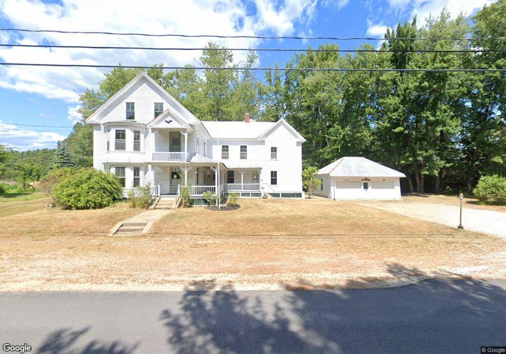
2 Covered Bridge Rd Ossipee, NH 03864
Estimated Value: $364,347 - $460,000
4
Beds
2
Baths
3,098
Sq Ft
$132/Sq Ft
Est. Value
About This Home
This home is located at 2 Covered Bridge Rd, Ossipee, NH 03864 and is currently estimated at $409,587, approximately $132 per square foot. 2 Covered Bridge Rd is a home with nearby schools including Ossipee Central School, Kingswood Regional Middle School, and Kingswood Regional High School.
Ownership History
Date
Name
Owned For
Owner Type
Purchase Details
Closed on
Aug 26, 2025
Sold by
Walsh Nicole and Lakeview Loan Servicing L
Bought by
Federal National Ntg Ass
Current Estimated Value
Purchase Details
Closed on
Nov 3, 2022
Sold by
Audette Lisa M and Eldridge Geraldine W
Bought by
Walsh Nicole
Home Financials for this Owner
Home Financials are based on the most recent Mortgage that was taken out on this home.
Original Mortgage
$270,000
Interest Rate
6.7%
Mortgage Type
Purchase Money Mortgage
Purchase Details
Closed on
Oct 26, 2018
Sold by
Eldridge Geraldine W
Bought by
Eldridge Geraldine W and Audette Lisa M
Create a Home Valuation Report for This Property
The Home Valuation Report is an in-depth analysis detailing your home's value as well as a comparison with similar homes in the area
Home Values in the Area
Average Home Value in this Area
Purchase History
| Date | Buyer | Sale Price | Title Company |
|---|---|---|---|
| Federal National Ntg Ass | $276,800 | -- | |
| Federal National Ntg Ass | $276,800 | -- | |
| Walsh Nicole | $300,000 | None Available | |
| Walsh Nicole | $300,000 | None Available | |
| Eldridge Geraldine W | -- | -- | |
| Eldridge Geraldine W | -- | -- | |
| Eldridge Geraldine W | -- | -- |
Source: Public Records
Mortgage History
| Date | Status | Borrower | Loan Amount |
|---|---|---|---|
| Previous Owner | Walsh Nicole | $270,000 |
Source: Public Records
Tax History
| Year | Tax Paid | Tax Assessment Tax Assessment Total Assessment is a certain percentage of the fair market value that is determined by local assessors to be the total taxable value of land and additions on the property. | Land | Improvement |
|---|---|---|---|---|
| 2024 | $3,589 | $309,400 | $125,700 | $183,700 |
| 2023 | $3,208 | $309,400 | $125,700 | $183,700 |
| 2022 | $2,060 | $112,100 | $30,600 | $81,500 |
| 2021 | $2,097 | $114,400 | $30,600 | $83,800 |
| 2020 | $1,951 | $114,400 | $30,600 | $83,800 |
| 2019 | $1,957 | $114,400 | $30,600 | $83,800 |
| 2018 | $2,622 | $113,500 | $24,500 | $89,000 |
| 2016 | $2,191 | $113,500 | $24,500 | $89,000 |
| 2015 | $2,080 | $113,500 | $24,500 | $89,000 |
| 2014 | $2,233 | $123,900 | $28,000 | $95,900 |
| 2013 | $2,155 | $123,900 | $28,000 | $95,900 |
Source: Public Records
Map
Nearby Homes
- 1785 White Mountain Hwy
- 23 Poco Dr
- 48 South Way
- 68 & 00 Gilman Valley & Route 25 W
- 00 Route 25 W Unit tbd
- Lot 18.1 White Mountain Hwy
- 68 Gilman Valley Rd
- 24 Flynn Ln
- 78 Berry Ln
- Map 206 Lot 28 Whittier Rd
- 156 Fawn Dr
- 5 Whittier Rd
- 1800 Route 16
- 190 Whittier Rd
- Lot 56-3 Ossipee Mountain Rd
- 498 Whittier Rd
- 96 Bryant Mill Rd
- 527 Tamworth Rd
- 31 Pinder Mill Rd
- 12 Circle Rd
- 2 Covered Bridge Rd
- 10 Route 16 and Route 41
- 4 Covered Bridge Rd
- 3 Covered Bridge Rd
- 8 Covered Bridge Rd
- 14 Covered Bridge Rd
- 2400 Route 16
- 20 Route 41
- RT. New Hampshire 41
- 10 Covered Bridge Rd
- 10 New Hampshire 41
- 2396 Route 16
- 14 Covered Bridge Rd
- 2420 NE Route 16
- 20 & 24 Route 41
- 16 Covered Bridge Rd
- 3 Depot Square St
- 7 Depot Square St
- 2415 New Hampshire 16
- 3 Depot Square St
Your Personal Tour Guide
Ask me questions while you tour the home.