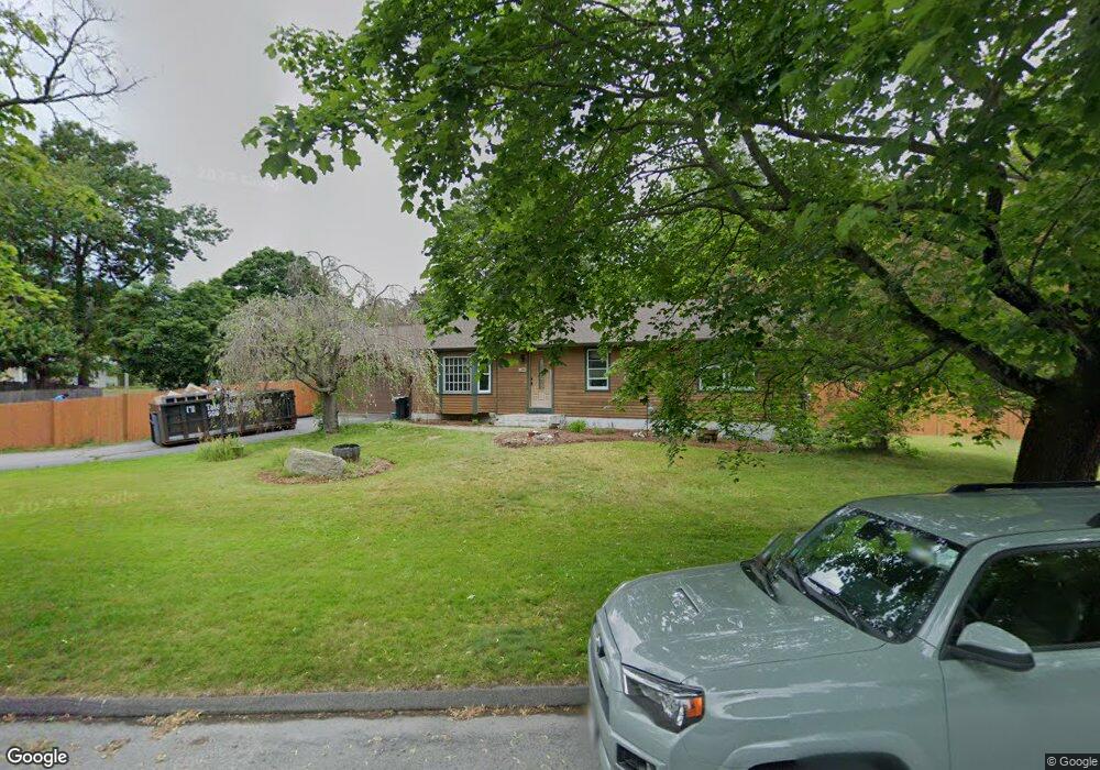
2 Donna Rd Worcester, MA 01609
Forest Grove NeighborhoodEstimated Value: $416,000 - $531,000
3
Beds
2
Baths
1,276
Sq Ft
$375/Sq Ft
Est. Value
About This Home
This home is located at 2 Donna Rd, Worcester, MA 01609 and is currently estimated at $478,477, approximately $374 per square foot. 2 Donna Rd is a home located in Worcester County with nearby schools including Chandler Magnet, Jacob Hiatt Magnet School, and Flagg Street School.
Ownership History
Date
Name
Owned For
Owner Type
Purchase Details
Closed on
Apr 14, 2004
Sold by
Mcgrath Erin L and Mcgrath Erin
Bought by
Mcgrath Carol A and Mcgrath Erin L
Current Estimated Value
Home Financials for this Owner
Home Financials are based on the most recent Mortgage that was taken out on this home.
Original Mortgage
$170,000
Outstanding Balance
$79,553
Interest Rate
5.58%
Mortgage Type
Purchase Money Mortgage
Estimated Equity
$398,924
Purchase Details
Closed on
Aug 5, 2002
Sold by
Hannan Michelle A and Branche Michelle A
Bought by
Michaels Jonathan and Mcgrath Erin
Home Financials for this Owner
Home Financials are based on the most recent Mortgage that was taken out on this home.
Original Mortgage
$180,670
Interest Rate
6.64%
Mortgage Type
Purchase Money Mortgage
Purchase Details
Closed on
May 12, 1987
Sold by
Swift Eleanor M
Bought by
Branche P
Create a Home Valuation Report for This Property
The Home Valuation Report is an in-depth analysis detailing your home's value as well as a comparison with similar homes in the area
Home Values in the Area
Average Home Value in this Area
Purchase History
| Date | Buyer | Sale Price | Title Company |
|---|---|---|---|
| Mcgrath Carol A | $183,000 | -- | |
| Michaels Jonathan | $183,000 | -- | |
| Branche P | $80,000 | -- |
Source: Public Records
Mortgage History
| Date | Status | Borrower | Loan Amount |
|---|---|---|---|
| Open | Mcgrath Carol A | $170,000 | |
| Previous Owner | Branche P | $180,670 | |
| Previous Owner | Branche P | $65,000 |
Source: Public Records
Tax History
| Year | Tax Paid | Tax Assessment Tax Assessment Total Assessment is a certain percentage of the fair market value that is determined by local assessors to be the total taxable value of land and additions on the property. | Land | Improvement |
|---|---|---|---|---|
| 2025 | $5,371 | $407,200 | $123,900 | $283,300 |
| 2024 | $5,247 | $381,600 | $123,900 | $257,700 |
| 2023 | $5,161 | $359,900 | $106,700 | $253,200 |
| 2022 | $4,590 | $301,800 | $85,300 | $216,500 |
| 2021 | $4,545 | $279,200 | $68,300 | $210,900 |
| 2020 | $4,359 | $256,400 | $68,100 | $188,300 |
| 2019 | $4,185 | $232,500 | $65,800 | $166,700 |
| 2018 | $4,062 | $214,800 | $65,800 | $149,000 |
| 2017 | $4,127 | $214,700 | $65,800 | $148,900 |
| 2016 | $4,178 | $202,700 | $54,700 | $148,000 |
| 2015 | $4,068 | $202,700 | $54,700 | $148,000 |
| 2014 | $3,972 | $203,300 | $54,700 | $148,600 |
Source: Public Records
Map
Nearby Homes
- 46 Barry Rd
- 61 Barry Rd
- 28 Lynnwood Ln
- 7 Primmett Ln
- 4004 Brompton Cir
- 84 Chester St
- 97 Parkton Ave
- 8 Salisbury Hill Blvd Unit 79
- 10 Salisbury Hill Blvd Unit 75
- 158 Chester St
- 90 Bjorklund Ave
- 16 Baiting Brook Ln Unit 64
- 25 Chester St
- 14 Baiting Brook Ln Unit 65
- 10 Baiting Brook Ln Unit 67
- 5 Chartwell Ln Unit 87
- 15 Dennison Rd
- 163 Moreland St
- 23 Leslie Rd
- 23 Orrison St
Your Personal Tour Guide
Ask me questions while you tour the home.