Estimated Value: $876,000 - $935,000
4
Beds
2
Baths
2,140
Sq Ft
$420/Sq Ft
Est. Value
About This Home
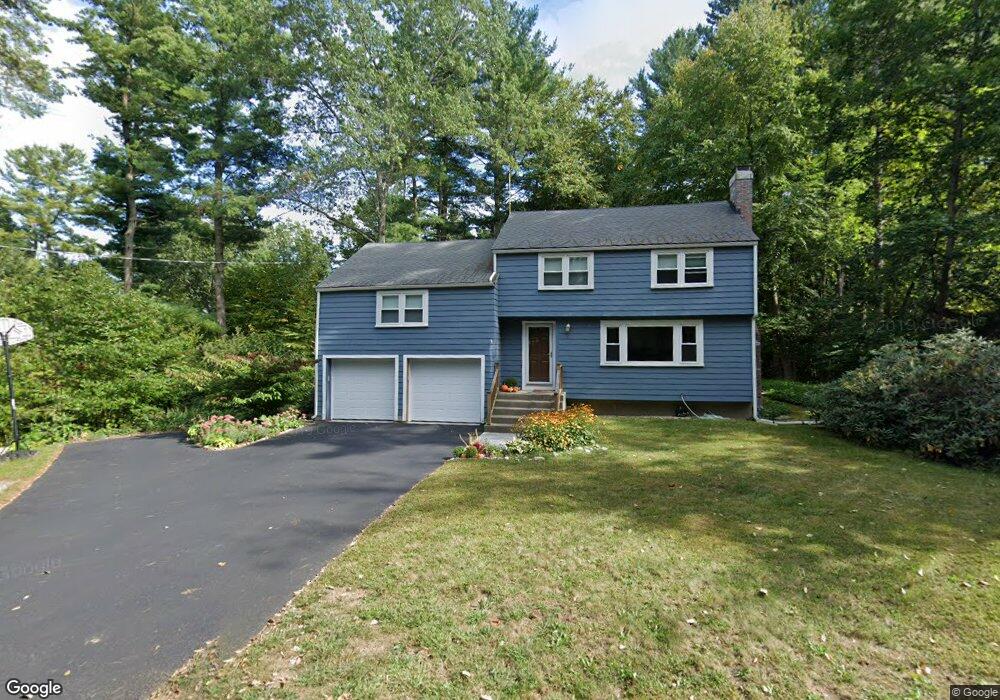
This home is located at 2 Duggan Rd, Acton, MA 01720 and is currently estimated at $899,050, approximately $420 per square foot. 2 Duggan Rd is a home located in Middlesex County with nearby schools including Acton-Boxborough Regional High School.
Ownership History
Date
Name
Owned For
Owner Type
Purchase Details
Closed on
Feb 15, 2021
Sold by
Nelken Les D and Ronan Helen A
Bought by
2021 Nelken-Ronan Ft
Current Estimated Value
Purchase Details
Closed on
Aug 15, 1997
Sold by
Vincent Jeffrey R and Vincent Elizabeth
Bought by
Ronan Helen A and Nelken Les D
Home Financials for this Owner
Home Financials are based on the most recent Mortgage that was taken out on this home.
Original Mortgage
$207,200
Interest Rate
7.56%
Mortgage Type
Purchase Money Mortgage
Purchase Details
Closed on
Feb 25, 1994
Sold by
Eyring Daniel O and Eyring Sally K
Bought by
Vincent Jeffrey R and Vincent Elizabeth
Home Financials for this Owner
Home Financials are based on the most recent Mortgage that was taken out on this home.
Original Mortgage
$182,000
Interest Rate
6.96%
Mortgage Type
Purchase Money Mortgage
Create a Home Valuation Report for This Property
The Home Valuation Report is an in-depth analysis detailing your home's value as well as a comparison with similar homes in the area
Home Values in the Area
Average Home Value in this Area
Purchase History
| Date | Buyer | Sale Price | Title Company |
|---|---|---|---|
| 2021 Nelken-Ronan Ft | -- | None Available | |
| Ronan Helen A | $259,000 | -- | |
| Vincent Jeffrey R | $228,000 | -- |
Source: Public Records
Mortgage History
| Date | Status | Borrower | Loan Amount |
|---|---|---|---|
| Previous Owner | Vincent Jeffrey R | $172,672 | |
| Previous Owner | Vincent Jeffrey R | $207,200 | |
| Previous Owner | Vincent Jeffrey R | $182,000 | |
| Previous Owner | Vincent Jeffrey R | $100,000 |
Source: Public Records
Tax History Compared to Growth
Tax History
| Year | Tax Paid | Tax Assessment Tax Assessment Total Assessment is a certain percentage of the fair market value that is determined by local assessors to be the total taxable value of land and additions on the property. | Land | Improvement |
|---|---|---|---|---|
| 2025 | $14,001 | $816,400 | $348,100 | $468,300 |
| 2024 | $13,201 | $791,900 | $348,100 | $443,800 |
| 2023 | $12,857 | $732,200 | $316,200 | $416,000 |
| 2022 | $10,349 | $532,100 | $275,100 | $257,000 |
| 2021 | $10,079 | $498,200 | $254,800 | $243,400 |
| 2020 | $9,520 | $494,800 | $254,800 | $240,000 |
| 2019 | $9,104 | $470,000 | $254,800 | $215,200 |
| 2018 | $9,111 | $470,100 | $254,800 | $215,300 |
| 2017 | $8,893 | $466,600 | $254,800 | $211,800 |
| 2016 | $8,773 | $456,200 | $254,800 | $201,400 |
| 2015 | $8,024 | $421,200 | $254,800 | $166,400 |
| 2014 | $7,955 | $409,000 | $254,800 | $154,200 |
Source: Public Records
Map
Nearby Homes
- 12 Olde Lantern Rd
- 92 Willow St Unit 3
- 92 Willow St Unit 2
- 90 Willow St Unit 1
- 3 Heather Hill Rd
- 30 Paul Revere Rd
- 89 Windsor Ave
- 4,7,8 Crestwood Ln
- 285 Central St Unit 285
- 68 Macintosh Ln
- 134 Russet Ln
- 96 Cedarwood Rd
- 5 Elm St Unit 1
- 9 Elm St Unit 1
- 220 Red Acre Rd
- 169 Main St
- 19 Railroad St Unit C2
- 31 Mohawk Dr
- 207 Boxboro Rd
- 131 Main St