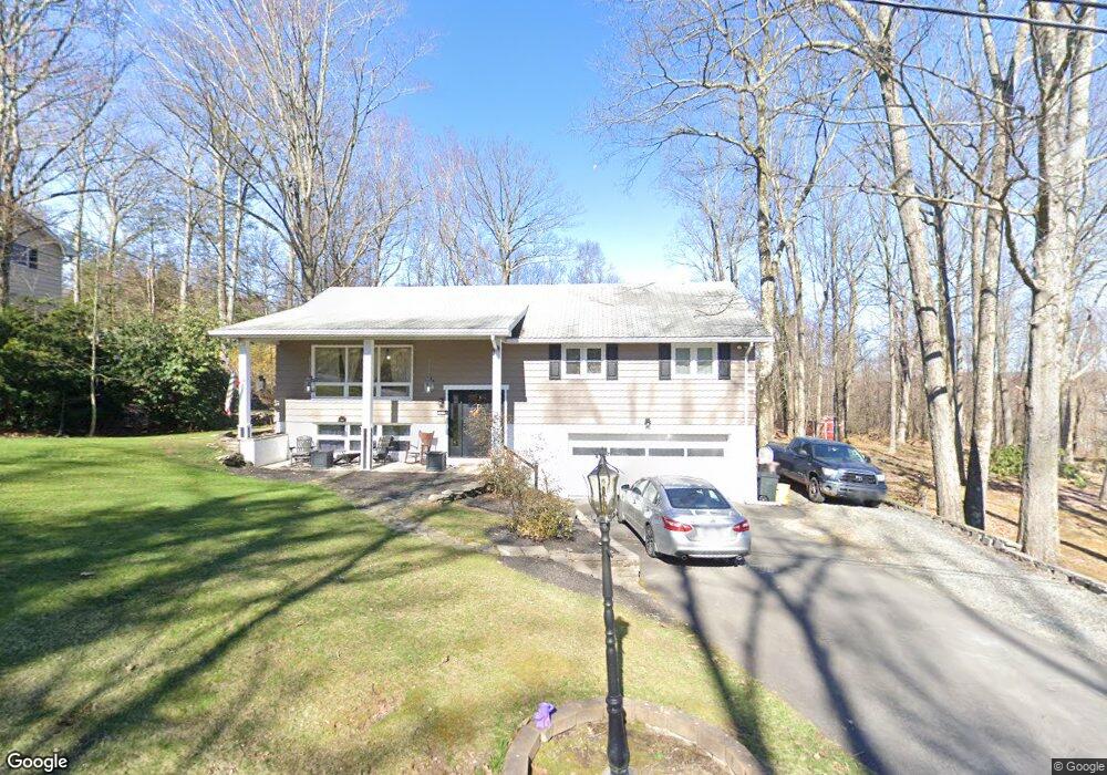
2 Earl Dr Clarks Summit, PA 18411
Estimated Value: $120,114 - $419,000
3
Beds
2
Baths
2,140
Sq Ft
$145/Sq Ft
Est. Value
About This Home
This home is located at 2 Earl Dr, Clarks Summit, PA 18411 and is currently estimated at $309,779, approximately $144 per square foot. 2 Earl Dr is a home located in Lackawanna County with nearby schools including Abington Heights High School and Abington Christian Academy.
Ownership History
Date
Name
Owned For
Owner Type
Purchase Details
Closed on
Oct 19, 2010
Sold by
Cartus Financial Corporation
Bought by
Sharrow Todd and Sharrow Nicole
Current Estimated Value
Home Financials for this Owner
Home Financials are based on the most recent Mortgage that was taken out on this home.
Original Mortgage
$182,541
Outstanding Balance
$119,843
Interest Rate
4.25%
Mortgage Type
FHA
Estimated Equity
$189,936
Purchase Details
Closed on
Oct 24, 2009
Sold by
Cook Robert I
Bought by
Cook Robert I and Cook Lucia
Home Financials for this Owner
Home Financials are based on the most recent Mortgage that was taken out on this home.
Original Mortgage
$160,001
Interest Rate
5.01%
Mortgage Type
FHA
Create a Home Valuation Report for This Property
The Home Valuation Report is an in-depth analysis detailing your home's value as well as a comparison with similar homes in the area
Home Values in the Area
Average Home Value in this Area
Purchase History
| Date | Buyer | Sale Price | Title Company |
|---|---|---|---|
| Sharrow Todd | $185,000 | None Available | |
| Cartus Financial Corporation | $185,000 | None Available | |
| Cook Robert I | -- | None Available |
Source: Public Records
Mortgage History
| Date | Status | Borrower | Loan Amount |
|---|---|---|---|
| Open | Cartus Financial Corporation | $182,541 | |
| Closed | Sharrow Todd | $182,541 | |
| Previous Owner | Cook Robert I | $160,001 |
Source: Public Records
Tax History Compared to Growth
Tax History
| Year | Tax Paid | Tax Assessment Tax Assessment Total Assessment is a certain percentage of the fair market value that is determined by local assessors to be the total taxable value of land and additions on the property. | Land | Improvement |
|---|---|---|---|---|
| 2025 | $4,869 | $20,000 | $1,000 | $19,000 |
| 2024 | $4,020 | $20,000 | $1,000 | $19,000 |
| 2023 | $4,020 | $20,000 | $1,000 | $19,000 |
| 2022 | $3,937 | $20,000 | $1,000 | $19,000 |
| 2021 | $3,937 | $20,000 | $1,000 | $19,000 |
| 2020 | $3,937 | $20,000 | $1,000 | $19,000 |
| 2019 | $3,807 | $20,000 | $1,000 | $19,000 |
| 2018 | $3,772 | $20,000 | $1,000 | $19,000 |
| 2017 | $3,752 | $20,000 | $1,000 | $19,000 |
| 2016 | $2,403 | $20,000 | $1,000 | $19,000 |
| 2015 | -- | $20,000 | $1,000 | $19,000 |
| 2014 | -- | $20,000 | $1,000 | $19,000 |
Source: Public Records
Map
Nearby Homes
- 9119 Valley View Dr
- 52 Ivywood Dr Unit L 6
- 9109 Valley View Dr
- 1215 Country Club Rd
- 0 Blvd
- 0 Milwaukee Rd Unit GSBSC254290
- 105 Fern Way
- 2441 Milwaukee Rd
- 406 Edgewood Dr S
- 630 Sunset St
- 112 Woodside Dr
- 812 Old Winola Rd
- 803 W Grove St
- 517 Grandview St
- 604 Oak Ln
- 524 Knapp Rd
- 1932 Newton Ransom Blvd
- 508 Gladiola Dr
- 101 Carriage Ln
- Lot 10 Colvin Estates